1930s Maps of Gentilly Terrace, New Orleans
Explore 2 historic maps of Gentilly Terrace from the 1930s. These maps offer a rare glimpse into what life looked like during the 1930s — showing old roads, neighborhoods, homes, and landmarks that have changed or disappeared over time.
Whether you're researching your family's past, planning a metal detecting trip, or studying how Gentilly Terrace's landscape evolved across the 1930s, these high-resolution maps are a powerful tool for exploring the history of this region.
- Focus on a specific era: All maps on this page are from the 1930s, giving you a focused view of this time period.
- See what’s changed: Compare century-old streets, trails, and buildings to today's modern landscape using overlays and satellite layers.
- Research with precision: Use these maps for genealogy, historical research, land use analysis, or educational projects.
- View, download, or print: Maps are fully viewable online in high resolution, and can be downloaded or printed for your own records.
Start exploring Gentilly Terrace's history through authentic maps from the 1930s. This is your window into the past.
Gentilly Terrace, New Orleans maps
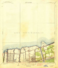
(2)- 1936 Map of Spanish Fort, 1938 Print
 1936 Spanish Fort1938 Print · USGSThe New Orleans lakefront in the mid-1930s reveals a landscape of leisure and engineering as the city expanded toward the water. Trace the footprints of Pontchartrain Beach Amusement Park, the historic docks at Milneburg, and the path of the Old Spanish Trail.
 - 1938 Map of Spanish Fort
 1938 Spanish Fort1938 Print · USGSThe southern shore of Lake Pontchartrain comes alive in the late 1930s as New Orleans expands toward the water. Trace the footprints of Shushan Airport, the historic Milneburg settlement, and leisure landmarks like Pontchartrain Beach and the Southern Yacht Club.2 unique versions available
End of results
Showing maps 1-2 of 2
Frequently asked questions
- What are the different types of historical maps available for Gentilly Terrace?
- What is the oldest map of Gentilly Terrace?
- Where can I purchase historical maps of Gentilly Terrace for my home or office?
- Where can I download high-res historical maps of Gentilly Terrace?
- Are there historical topographic maps available for Gentilly Terrace?
- Is there historical aerial imagery available for Gentilly Terrace?
- Where are historical maps of Gentilly Terrace sourced from?