1990s Maps of Pontchartrain Beach, New Orleans
Explore 2 historic maps of Pontchartrain Beach from the 1990s. These maps offer a rare glimpse into what life looked like during the 1990s — showing old roads, neighborhoods, homes, and landmarks that have changed or disappeared over time.
Whether you're researching your family's past, planning a metal detecting trip, or studying how Pontchartrain Beach's landscape evolved across the 1990s, these high-resolution maps are a powerful tool for exploring the history of this region.
- Focus on a specific era: All maps on this page are from the 1990s, giving you a focused view of this time period.
- See what’s changed: Compare century-old streets, trails, and buildings to today's modern landscape using overlays and satellite layers.
- Research with precision: Use these maps for genealogy, historical research, land use analysis, or educational projects.
- View, download, or print: Maps are fully viewable online in high resolution, and can be downloaded or printed for your own records.
Start exploring Pontchartrain Beach's history through authentic maps from the 1990s. This is your window into the past.
Pontchartrain Beach, New Orleans maps
(2)- 1992 Map of Spanish Fort
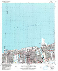 1992 Spanish Fort1992 Print · USGSThe northern lakefront of New Orleans is shown here in the early nineties, featuring a highly developed shoreline of harbors and universities. Researchers can trace local landmarks like Spanish Fort, City Park, and the Hebrew Rest Cem.2 unique versions available
 - 1999 Map of Spanish Fort, 2000 Print
 1999 Spanish Fort2000 Print · USGSThe Lake Pontchartrain shoreline in northern New Orleans appears here just before the turn of the millennium. Researchers can trace the layout of historic Spanish Fort, locate the cluster of Jewish Cemeteries, and see the development around Seabrook.
End of results
Showing maps 1-2 of 2
Frequently asked questions
- What are the different types of historical maps available for Pontchartrain Beach?
- What is the oldest map of Pontchartrain Beach?
- Where can I purchase historical maps of Pontchartrain Beach for my home or office?
- Where can I download high-res historical maps of Pontchartrain Beach?
- Are there historical topographic maps available for Pontchartrain Beach?
- Is there historical aerial imagery available for Pontchartrain Beach?
- Where are historical maps of Pontchartrain Beach sourced from?