1900s (20th Century) Maps of Breton, Louisiana
Explore 8 historic maps of Breton from the 1900s (20th Century). These maps offer a rare glimpse into what life looked like during the 1900s — showing old roads, neighborhoods, homes, and landmarks that have changed or disappeared over time.
Whether you're researching your family's past, planning a metal detecting trip, or studying how Breton's landscape evolved across the 1900s, these high-resolution maps are a powerful tool for exploring the history of this region.
- Focus on a specific era: All maps on this page are from the 1900s, giving you a focused view of this time period.
- See what’s changed: Compare century-old streets, trails, and buildings to today's modern landscape using overlays and satellite layers.
- Research with precision: Use these maps for genealogy, historical research, land use analysis, or educational projects.
- View, download, or print: Maps are fully viewable online in high resolution, and can be downloaded or printed for your own records.
Start exploring Breton's history through authentic maps from the 1900s. This is your window into the past.
Breton, LA maps
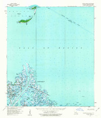
(8)- 1950 Map of Breton Islands, 1958 Print
 1950 Breton Islands1958 Print · USGSThe Louisiana coast in the early fifties is seen through this survey of Breton Island, an area dedicated to the Breton National Wildlife Refuge. Trace navigational aids like the Breton Island Light and maritime landmarks near North Point.
 - 1953 Map of Breton Island
 1953 Breton Island1953 Print · USGSThe fragile barrier islands and marshlands of the Mississippi Delta are shown here in the early 1950s. Researchers can trace intricate coastal features and family-named landmarks like Harris Pond, Japan Island, and the Breton Island Light.
 - 1957 Map of Breton Sound, 1967 Print
 1957 Breton Sound1967 Print · USGSThe Mississippi River delta is captured here in the mid-fifties, showing the fragile marshlands and river-dependent towns of the Louisiana coast. Genealogists and historians can trace riverside settlements like Pointe a la Hache, Pilottown, and Port Sulphur.3 unique versions available
 - 1958 Map of Breton Island, 1963 Print
 1958 Breton Island1963 Print · USGSThe Plaquemines Parish coast in the late fifties shows the massive Mississippi River Gulf Outlet Channel under construction. Map collectors and researchers can trace the industrial footprint of the Delta Duck Oil Field and Romere Pass Oil and Gas Field among the islands of the Breton National Wildlife Refuge.3 unique versions available
 - 1961 Map of Breton Sound
 1961 Breton Sound1961 Print · USGSThe Louisiana delta and the outer marshes of Plaquemines Parish are captured here at the start of the 1960s. Researchers can trace the river settlements from Davant to Venice, locate isolated stations like Port Eads, and find old sites such as Fort Jackson.
 - 1971 Map of Breton Islands, 1972 Print
 1971 Breton Islands1972 Print · USGSThe barrier islands and wildlife sanctuary of Plaquemines Parish are captured here during the early 1970s. Researchers can trace the shifting sands of North Point and the industrial footprint of the Oil Field and Mississippi River Gulf Outlet Canal.
 - 1983 Map of Mississippi River Delta
 1983 Mississippi River Delta1983 Print · USGSThe lower Mississippi delta in the early eighties shows the thin line of human habitation clinging to the river levee between the vast marshes and the gulf. Genealogists and historians can trace the riverside communities of Empire, Triumph, and Nairn alongside the industrial Sulphur Mining Area.2 unique versions available
 - 1993 Map of Breton Islands
 1993 Breton Islands1993 Print · USGSThe Breton Islands remain a critical wildlife sanctuary and industrial zone in the early nineties. Researchers can trace the shifting sands of Breton National Wildlife Refuge alongside an active Oil Field and the Mississippi River Gulf Outlet Canal.
End of results
Showing maps 1-8 of 8
Frequently asked questions
- What are the different types of historical maps available for Breton?
- What is the oldest map of Breton?
- Where can I purchase historical maps of Breton for my home or office?
- Where can I download high-res historical maps of Breton?
- Are there historical topographic maps available for Breton?
- Is there historical aerial imagery available for Breton?
- Where are historical maps of Breton sourced from?