Old Maps of Deville, Louisiana for Metal Detecting
Plan your next treasure hunt with 20 historic maps of Deville. Find old homesites, ghost towns, trails, and gathering spots that may be lost to time — perfect for identifying promising metal detecting locations.
- Locate forgotten sites: Uncover places like long-lost settlements, abandoned rail lines, or gathering spots.
- Plan better hunts: Use map overlays combined with LiDAR or satellite views to narrow in on historically rich areas.
- Made for detectorists: Thousands of hobbyists use these maps to discover relics, coins, and hidden history.
Use these historic maps to boost your research and find new opportunities beneath the surface of Deville.
Deville, LA maps
(20)- 1941 Map of Buckeye, 1944 Print
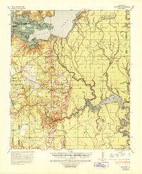 1941 Buckeye1944 Print · USGSCentral Louisiana’s wetland and prairie interface is captured here in the early 1940s, showing the intricate water systems of the Rapides and La Salle parish lines. Genealogists can locate family landmarks like Barron Chapel, Guillory School, and the settlement of Holloway.2 unique versions available
 - 1953 Map of Alexandria, 1963 Print
 1953 Alexandria1963 Print · USGSCentral Louisiana during the early fifties is mapped here at the intersection of the piney woods and the Red River valley. Genealogists and historians can trace the rail-and-river network connecting towns like Alexandria, Natchitoches, and the grounds of Camp Beauregard.3 unique versions available
 - 1955 Map of Alexandria
 1955 Alexandria1955 Print · USGSCentral Louisiana in the mid-fifties is a landscape of river-port cities, sprawling timberlands, and massive military reservations. Genealogists and historians can trace the rail networks of the Texas & Pacific RR and locate sites like Camp Polk Military Reservation and Natchitoches.
 - 1959 Map of Buckeye, 1960 Print
 1959 Buckeye1960 Print · USGSLouisiana parish lines converge in this late-fifties landscape of complex bayous and oil fields. Researchers can trace rural family roots through numerous local landmarks like Marthas Chapel, Guillory Cem, and the old settlement of Buckeye.2 unique versions available
 - 1972 Map of Buckeye, 1974 Print
 1972 Buckeye1974 Print · USGSCentral Louisiana's rural landscape at the start of the 1970s reveals a mix of old family settlements and emerging energy infrastructure. Genealogists and local historians can trace legacy sites like Bradford Cem, the settlement at Buckeye, and the Oil Field near Big Island.2 unique versions available
 - 1972 Map of Holloway, 1974 Print
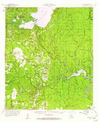
 1972 Holloway1974 Print · USGSCentral Louisiana wetlands meet industrial expansion in the early 1970s as the Little River flows into the vast Catahoula Lake. Genealogists and local historians can trace the community of Holloway, locate Marthas Chapel, or follow the Old Railroad Grade through the bayous.3 unique versions available
 - 1986 Map of Alexandria
 1986 Alexandria1986 Print · USGSCentral Louisiana in the mid-eighties shows a landscape of strategic military installations and deep river-valley agriculture. Researchers can trace the footprints of England Air Force Base, Camp Beauregard, and the extensive Kisatchie National Forest.2 unique versions available
 - 1994 Map of Buckeye, 1996 Print
 1994 Buckeye1996 Print · USGSThe transition from the central Louisiana prairies to the bayous of the Red River valley is captured here in the mid-1990s. Genealogists can locate numerous rural burial sites like Hopewell Cem and Guillory Cem nestled among the wetlands of Big Island.
 - 1994 Map of Holloway, 1996 Print
 1994 Holloway1996 Print · USGSLouisiana's wetlands meet industrial oil production in the mid-1990s as the northern shores of Catahoula Lake stretch across the Rapides Parish line. Researchers can trace rural landmarks like Holloway, local cemeteries, and the extent of the South Catahoula Oil Field.
 - 1998 Map of Holloway, 2004 Print
 1998 Holloway2004 Print · USGSThe marshy parish borders of Central Louisiana were a landscape of industrial extraction and conservation at the close of the twentieth century. Researchers can trace the boundaries of the South Catahoula Oil Field, locate the Holloway settlement, and explore the wetlands of Catahoula Lake.
 - 2012 Map of Holloway, 2012 Print
 2012 Holloway2012 Print · USGSCovers Deville, including Holloway, Rapides Parish, and other nearby areas
 - 2012 Map of Buckeye, 2012 Print
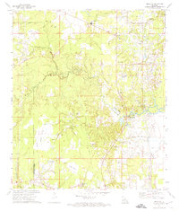
 2012 Buckeye2012 Print · USGSCovers Deville, including North Point, Barron, and other nearby areas
 - 2015 Map of Buckeye, 2015 Print
 2015 Buckeye2015 Print · USGSCovers Deville, including North Point, Barron, and other nearby areas
 - 2015 Map of Holloway, 2015 Print
 2015 Holloway2015 Print · USGSCovers Deville, including Holloway, Rapides Parish, and other nearby areas
 - 2018 Map of Buckeye, 2018 Print
 2018 Buckeye2018 Print · USGSCovers Deville, including North Point, Barron, and other nearby areas
 - 2018 Map of Holloway, 2018 Print
 2018 Holloway2018 Print · USGSCovers Deville, including Holloway, Rapides Parish, and other nearby areas
 - 2020 Map of Holloway, 2020 Print
 2020 Holloway2020 Print · USGSCovers Deville, including Holloway, Rapides Parish, and other nearby areas
 - 2020 Map of Buckeye, 2020 Print
 2020 Buckeye2020 Print · USGSCovers Deville, including North Point, Barron, and other nearby areas
 - 2024 Map of Buckeye, 2024 Print
 2024 Buckeye2024 Print · USGSRapides and Avoyelles Parishes are shown in the modern era as a landscape of rural prairies and complex bayous. Researchers can trace family history through numerous burial sites like Burlew Cem and Slocum Cem or explore the unique geography of Big Island.
 - 2024 Map of Holloway, 2024 Print
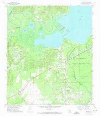
 2024 Holloway2024 Print · USGSHolloway and Deville sit at the edge of the Catahoula Lake basin in the early 2020s, showing a landscape defined by prairie and floodplain. Researchers can trace rural family-named roads like Reed Lawrence Rd and explore the edges of the NG Beauregard Training Range.
End of results
Showing maps 1-20 of 20
Top cities near Deville
Frequently asked questions
- What are the different types of historical maps available for Deville?
- What is the oldest map of Deville?
- Where can I purchase historical maps of Deville for my home or office?
- Where can I download high-res historical maps of Deville?
- Are there historical topographic maps available for Deville?
- Is there historical aerial imagery available for Deville?
- Where are historical maps of Deville sourced from?