1960s Maps of Lexington Place, Louisiana
Explore 3 historic maps of Lexington Place from the 1960s. These maps offer a rare glimpse into what life looked like during the 1960s — showing old roads, neighborhoods, homes, and landmarks that have changed or disappeared over time.
Whether you're researching your family's past, planning a metal detecting trip, or studying how Lexington Place's landscape evolved across the 1960s, these high-resolution maps are a powerful tool for exploring the history of this region.
- Focus on a specific era: All maps on this page are from the 1960s, giving you a focused view of this time period.
- See what’s changed: Compare century-old streets, trails, and buildings to today's modern landscape using overlays and satellite layers.
- Research with precision: Use these maps for genealogy, historical research, land use analysis, or educational projects.
- View, download, or print: Maps are fully viewable online in high resolution, and can be downloaded or printed for your own records.
Start exploring Lexington Place's history through authentic maps from the 1960s. This is your window into the past.
Lexington Place, LA maps
(3)- 1961 Map of Breton Sound
 1961 Breton Sound1961 Print · USGSThe Louisiana delta and the outer marshes of Plaquemines Parish are captured here at the start of the 1960s. Researchers can trace the river settlements from Davant to Venice, locate isolated stations like Port Eads, and find old sites such as Fort Jackson.
 - 1967 Map of Chalmette, 1968 Print
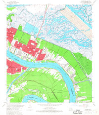 1967 Chalmette1968 Print · USGSCoastal St. Bernard Parish and the New Orleans riverfront are captured during a period of industrial and residential expansion in the late sixties. Trace the historical footprint of Chalmette and find local landmarks like Merrit Cem and Chalmette National Historical Park.7 unique versions available
 - 1969 Map of St. Bernard, 1970 Print
 1969 St. Bernard1970 Print · USGSCoastal St. Bernard Parish comes alive in this late-sixties survey of the riverfront and marshlands during a period of significant industrial and maritime growth. Researchers can trace the development of Chalmette, find family landmarks like St Bernard Memorial Gardens, and explore the winding Southern Railway through Violet and Verret.
End of results
Showing maps 1-3 of 3
Top cities near Lexington Place
- New Orleans historical maps
- Algiers historical maps
- Chalmette historical maps
- Gretna historical maps
- Westwego historical maps
- Jean Lafitte historical maps
Frequently asked questions
- What are the different types of historical maps available for Lexington Place?
- What is the oldest map of Lexington Place?
- Where can I purchase historical maps of Lexington Place for my home or office?
- Where can I download high-res historical maps of Lexington Place?
- Are there historical topographic maps available for Lexington Place?
- Is there historical aerial imagery available for Lexington Place?
- Where are historical maps of Lexington Place sourced from?