1990s Maps of Hahnville, Louisiana
Explore 2 historic maps of Hahnville from the 1990s. These maps offer a rare glimpse into what life looked like during the 1990s — showing old roads, neighborhoods, homes, and landmarks that have changed or disappeared over time.
Whether you're researching your family's past, planning a metal detecting trip, or studying how Hahnville's landscape evolved across the 1990s, these high-resolution maps are a powerful tool for exploring the history of this region.
- Focus on a specific era: All maps on this page are from the 1990s, giving you a focused view of this time period.
- See what’s changed: Compare century-old streets, trails, and buildings to today's modern landscape using overlays and satellite layers.
- Research with precision: Use these maps for genealogy, historical research, land use analysis, or educational projects.
- View, download, or print: Maps are fully viewable online in high resolution, and can be downloaded or printed for your own records.
Start exploring Hahnville's history through authentic maps from the 1990s. This is your window into the past.
Hahnville, LA maps
(2)- 1992 Map of Hahnville
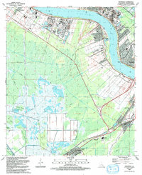 1992 Hahnville1992 Print · USGSSt. Charles Parish in the early nineties shows a landscape of heavy industry and riverfront communities along the Mississippi. Genealogists and historians can trace local landmarks like Holy Rosary Ch, Green Hill Cem, and the Triche Airfield.
 - 1995 Map of Hahnville, 1999 Print
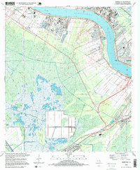 1995 Hahnville1999 Print · USGSSt. Charles Parish in the mid-1990s reveals a unique intersection of heavy industry, bayou life, and the winding Mississippi. Genealogists can trace family landmarks like Holy Rosary Ch and Green Hill Cem or locate the old Boutte Sch.
End of results
Showing maps 1-2 of 2
Top cities near Hahnville
Frequently asked questions
- What are the different types of historical maps available for Hahnville?
- What is the oldest map of Hahnville?
- Where can I purchase historical maps of Hahnville for my home or office?
- Where can I download high-res historical maps of Hahnville?
- Are there historical topographic maps available for Hahnville?
- Is there historical aerial imagery available for Hahnville?
- Where are historical maps of Hahnville sourced from?