1950s Maps of Folsom, Louisiana
Explore 5 historic maps of Folsom from the 1950s. These maps offer a rare glimpse into what life looked like during the 1950s — showing old roads, neighborhoods, homes, and landmarks that have changed or disappeared over time.
Whether you're researching your family's past, planning a metal detecting trip, or studying how Folsom's landscape evolved across the 1950s, these high-resolution maps are a powerful tool for exploring the history of this region.
- Focus on a specific era: All maps on this page are from the 1950s, giving you a focused view of this time period.
- See what’s changed: Compare century-old streets, trails, and buildings to today's modern landscape using overlays and satellite layers.
- Research with precision: Use these maps for genealogy, historical research, land use analysis, or educational projects.
- View, download, or print: Maps are fully viewable online in high resolution, and can be downloaded or printed for your own records.
Start exploring Folsom's history through authentic maps from the 1950s. This is your window into the past.
Folsom, LA maps
(5)- 1950 Map of Folsom
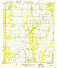 1950 Folsom1950 Print · USGSThe northern piney woods of St. Tammany Parish are captured here at mid-century, centered on the crossroads of Folsom. Local historians can trace family roots at Owens Cem and Pierre Cem or locate early schools like the Folsom Rosenwald Sch.
 - 1954 Map of Folsom, 1958 Print
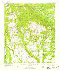
 1954 Folsom1958 Print · USGSLouisiana's northshore parishes come alive in the mid-1950s, revealing a landscape of winding river prongs and small rural settlements. Genealogists can trace family roots through numerous sites like Magee Cem, Fivemile Still Cem, and the Folsom Rosenwald Sch.
 - 1954 Map of Baton Rouge, 1974 Print
 1954 Baton Rouge1974 Print · USGSSoutheast Louisiana in the mid-fifties is captured here during a period of transition for its river and rail economies. Researchers can trace the path of the Mississippi River and find landmarks like the Bonnet Carre Spillway and Bayou Plaquemine.2 unique versions available
 - 1956 Map of Baton Rouge
 1956 Baton Rouge1956 Print · USGSSouth Louisiana at the height of the mid-century oil boom shows a landscape of river oxbows and rising industry. Researchers can trace family roots through river towns like Scotlandville or locate early industrial sites and Oil wells near Lake Maurepas.
 - 1958 Map of Folsom, 1959 Print
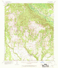
 1958 Folsom1959 Print · USGSSt. Tammany and Washington Parishes are shown in the late fifties as a landscape of rural churches, schools, and family cemeteries. Genealogists and historians can trace family locations through sites like Fivemile Still Cem, the Folsom Rosenwald Sch, and the St Gertrude Convent.2 unique versions available
End of results
Showing maps 1-5 of 5
Top cities near Folsom
- Hammond historical maps
- Covington historical maps
- Ponchatoula historical maps
- Franklinton historical maps
- Abita Springs historical maps
- Madisonville historical maps
Frequently asked questions
- What are the different types of historical maps available for Folsom?
- What is the oldest map of Folsom?
- Where can I purchase historical maps of Folsom for my home or office?
- Where can I download high-res historical maps of Folsom?
- Are there historical topographic maps available for Folsom?
- Is there historical aerial imagery available for Folsom?
- Where are historical maps of Folsom sourced from?