1930s Maps of Castine Point, Mandeville
Explore 2 historic maps of Castine Point from the 1930s. These maps offer a rare glimpse into what life looked like during the 1930s — showing old roads, neighborhoods, homes, and landmarks that have changed or disappeared over time.
Whether you're researching your family's past, planning a metal detecting trip, or studying how Castine Point's landscape evolved across the 1930s, these high-resolution maps are a powerful tool for exploring the history of this region.
- Focus on a specific era: All maps on this page are from the 1930s, giving you a focused view of this time period.
- See what’s changed: Compare century-old streets, trails, and buildings to today's modern landscape using overlays and satellite layers.
- Research with precision: Use these maps for genealogy, historical research, land use analysis, or educational projects.
- View, download, or print: Maps are fully viewable online in high resolution, and can be downloaded or printed for your own records.
Start exploring Castine Point's history through authentic maps from the 1930s. This is your window into the past.
Castine Point, Mandeville maps
(2)- 1935 Map of Covington
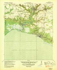
 1935 Covington1935 Print · USGSSt. Tammany Parish thrived as a river and rail hub during the mid-1930s, anchored by the bustling towns along Lake Pontchartrain. Researchers can trace the path of the Illinois Central RR and locate local landmarks like the Rosenwald Sch or the Chefuncte LH.3 unique versions available
 - 1939 Map of Covington
 1939 Covington1939 Print · USGSSt. Tammany Parish thrived as a river and rail corridor before mid-century, where the Bogue Falaya met the northern shore of Lake Pontchartrain. Genealogists and historians can trace family roots through the Rosenwald Sch, Little Zion Ch & Cem, and the old rail routes of the Illinois Central.
End of results
Showing maps 1-2 of 2
Frequently asked questions
- What are the different types of historical maps available for Castine Point?
- What is the oldest map of Castine Point?
- Where can I purchase historical maps of Castine Point for my home or office?
- Where can I download high-res historical maps of Castine Point?
- Are there historical topographic maps available for Castine Point?
- Is there historical aerial imagery available for Castine Point?
- Where are historical maps of Castine Point sourced from?