1900s (20th Century) Maps of Lake Bruin, Louisiana
Explore 10 historic maps of Lake Bruin from the 1900s (20th Century). These maps offer a rare glimpse into what life looked like during the 1900s — showing old roads, neighborhoods, homes, and landmarks that have changed or disappeared over time.
Whether you're researching your family's past, planning a metal detecting trip, or studying how Lake Bruin's landscape evolved across the 1900s, these high-resolution maps are a powerful tool for exploring the history of this region.
- Focus on a specific era: All maps on this page are from the 1900s, giving you a focused view of this time period.
- See what’s changed: Compare century-old streets, trails, and buildings to today's modern landscape using overlays and satellite layers.
- Research with precision: Use these maps for genealogy, historical research, land use analysis, or educational projects.
- View, download, or print: Maps are fully viewable online in high resolution, and can be downloaded or printed for your own records.
Start exploring Lake Bruin's history through authentic maps from the 1900s. This is your window into the past.
Lake Bruin, LA maps
(10)- 1909 Map of Delta Bridge
 1909 Delta Bridge1909 Print · USGSTensas Parish was a landscape of riverfront estates and early rail lines in the years before the Great War. Researchers can trace ancestral property lines and community centers like Oneonta Plantation, Rock of Ages Church, and the St Louis Iron Mountain and Southern Railroad.
 - 1939 Map of Locust Ridge, 1965 Print
 1939 Locust Ridge1965 Print · USGSThe Mississippi Delta in the late 1930s reveals a land of sprawling plantations and bayou settlements along the Louisiana border. Genealogists can trace family landmarks like the Mayflower Cem, Maryland Plantation Cem, and New St Mark Ch among the meanders of the river.
 - 1953 Map of Natchez, 1966 Print
 1953 Natchez1966 Print · USGSSouthwest Mississippi and the Louisiana border country come alive in this mid-century survey of the river valley and forest lands. Researchers can trace the rail lines of the Illinois Central RR and locate rural hubs like Gloster and Ferriday.3 unique versions available
 - 1956 Map of Natchez
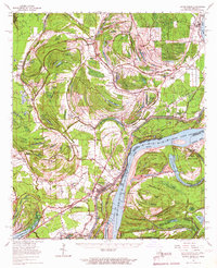
 1956 Natchez1956 Print · USGSThe Mississippi River borderlands and the Pine Hills come alive in this mid-fifties study of the Natchez region. Genealogists and historians can trace rail-era towns along the Illinois Central RR and explore the oxbows of Lake Bruin and Lake Concordia.
 - 1959 Map of Natchez
 1959 Natchez1959 Print · USGSSouthwestern Mississippi and eastern Louisiana are captured in the late fifties, showing a landscape defined by the winding Mississippi River and the timbered Homochitto National Forest. Researchers can trace the sprawling Illinois Central RR and find rural landmarks like Union Church and Camp Van Dorn (Abandoned).
 - 1963 Map of Lake Bruin, 1964 Print
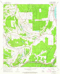 1963 Lake Bruin1964 Print · USGSTensas Parish in the early sixties is a landscape of expansive plantations and ancient river bends along the Mississippi. Genealogists and historians can trace family-named sites like Thistle Ridge Plantation, remote burial grounds such as Gold Bell Cem, and the small settlement of Wilsonia.2 unique versions available
 - 1965 Map of Locust Ridge, 1967 Print
 1965 Locust Ridge1967 Print · USGSThe Louisiana-Mississippi riverlands are captured here in the mid-1960s, showing the intricate oxbow lakes and rail-connected settlements along the river's edge. Researchers can locate family-named estates like Winona Plantation and rural landmarks like Choctaw Chapel and the Shiloh Ch.2 unique versions available
 - 1984 Map of Natchez
 1984 Natchez1984 Print · USGSThe Mississippi-Louisiana borderlands in the mid-eighties show a landscape defined by the winding Mississippi River and its rail networks. Trace family history at the Natchez National Cemetery or explore the river towns of Vidalia and Ferriday.
 - 1991 Map of Natchez, 1992 Print
 1991 Natchez1992 Print · USGSThe Mississippi River valley at the turn of the nineties reveals a landscape of oxbow lakes, river landings, and bustling bluff-top towns. Genealogists and historians can trace the rail corridors of the Illinois Central Gulf Railroad through Fayette or locate family roots in riverside settlements like Waterproof and St Joseph.
 - 1994 Map of Lake Bruin, 1997 Print
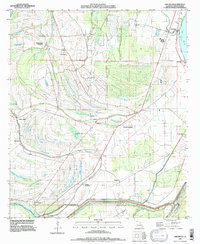 1994 Lake Bruin1997 Print · USGSTensas Parish in the 1990s showcases a river-bound landscape of historic plantations and winding bayous. Researchers can trace family history at Thistle Ridge Plantation or locate burial sites like Gold Bell Cem and Oriental Cem.
End of results
Showing maps 1-10 of 10
Top cities near Lake Bruin
Frequently asked questions
- What are the different types of historical maps available for Lake Bruin?
- What is the oldest map of Lake Bruin?
- Where can I purchase historical maps of Lake Bruin for my home or office?
- Where can I download high-res historical maps of Lake Bruin?
- Are there historical topographic maps available for Lake Bruin?
- Is there historical aerial imagery available for Lake Bruin?
- Where are historical maps of Lake Bruin sourced from?