1940s Maps of Gueydan, Louisiana
Explore 2 historic maps of Gueydan from the 1940s. These maps offer a rare glimpse into what life looked like during the 1940s — showing old roads, neighborhoods, homes, and landmarks that have changed or disappeared over time.
Whether you're researching your family's past, planning a metal detecting trip, or studying how Gueydan's landscape evolved across the 1940s, these high-resolution maps are a powerful tool for exploring the history of this region.
- Focus on a specific era: All maps on this page are from the 1940s, giving you a focused view of this time period.
- See what’s changed: Compare century-old streets, trails, and buildings to today's modern landscape using overlays and satellite layers.
- Research with precision: Use these maps for genealogy, historical research, land use analysis, or educational projects.
- View, download, or print: Maps are fully viewable online in high resolution, and can be downloaded or printed for your own records.
Start exploring Gueydan's history through authentic maps from the 1940s. This is your window into the past.
Gueydan, LA maps
(2)- 1946 Map of Morse
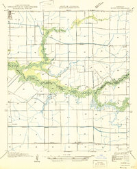 1946 Morse1946 Print · USGSCoastal Louisiana at the end of the Second World War reveals a landscape defined by its bayous and early irrigation networks. Genealogists and researchers can locate old rail stops like Haire Sta and settlements such as Morse, Gueydan, and Lyons Point.
 - 1949 Map of Gueydan
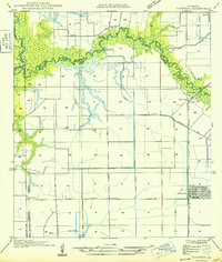 1949 Gueydan1949 Print · USGSThe coastal prairies of Vermilion Parish meet the bayous of Acadia in the late 1940s. Genealogists can locate the Legia Cem and trace the Southern Pacific rail line through Riceville and into the streets of Gueydan.
End of results
Showing maps 1-2 of 2
Top cities near Gueydan
- Crowley historical maps
- Jennings historical maps
- Rayne historical maps
- Kaplan historical maps
- Lake Arthur historical maps
- Estherwood historical maps
See more
Frequently asked questions
- What are the different types of historical maps available for Gueydan?
- What is the oldest map of Gueydan?
- Where can I purchase historical maps of Gueydan for my home or office?
- Where can I download high-res historical maps of Gueydan?
- Are there historical topographic maps available for Gueydan?
- Is there historical aerial imagery available for Gueydan?
- Where are historical maps of Gueydan sourced from?