1950s Maps of Caswell, Maine
Explore 5 historic maps of Caswell from the 1950s. These maps offer a rare glimpse into what life looked like during the 1950s — showing old roads, neighborhoods, homes, and landmarks that have changed or disappeared over time.
Whether you're researching your family's past, planning a metal detecting trip, or studying how Caswell's landscape evolved across the 1950s, these high-resolution maps are a powerful tool for exploring the history of this region.
- Focus on a specific era: All maps on this page are from the 1950s, giving you a focused view of this time period.
- See what’s changed: Compare century-old streets, trails, and buildings to today's modern landscape using overlays and satellite layers.
- Research with precision: Use these maps for genealogy, historical research, land use analysis, or educational projects.
- View, download, or print: Maps are fully viewable online in high resolution, and can be downloaded or printed for your own records.
Start exploring Caswell's history through authentic maps from the 1950s. This is your window into the past.
Caswell, ME maps
(5)- 1951 Map of Van Buren
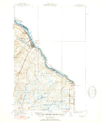 1951 Van Buren1951 Print · USGSSt John River life and the northern Maine border are detailed here during the mid-century, showing the international boundary with New Brunswick. Researchers can trace the Bangor and Aroostook rail line through Keegan or locate rural landmarks like St Joseph Ch and Bernie Sch.5 unique versions available
 - 1951 Map of Fort Fairfield, 1952 Print
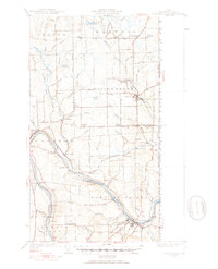 1951 Fort Fairfield1952 Print · USGSAroostook County's borderlands come alive in this mid-century survey, showing the busy rail-and-river network connecting Maine to New Brunswick. Genealogists and historians can trace family-named corners and rural schoolhouses such as Kelly Sch, Grimes Mill, and the State Fish Hatchery.5 unique versions available
 - 1953 Map of Fort Fairfield NW, 1955 Print
 1953 Fort Fairfield NW1955 Print · USGSNorthern Maine's borderlands show a massive transition during the early Cold War as large military installations rose among rural townships. Genealogists and historians can trace local life through the Kelly Sch, Somers Corner, and the Lister Community Ch.2 unique versions available
 - 1953 Map of Limestone, 1955 Print
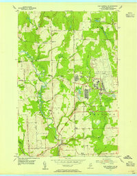
 1953 Limestone1955 Print · USGSUpper Aroostook County is seen here during the early Cold War era, just as the massive Loring Air Force Base was becoming a major presence. You can trace early family connections through sites like Pleasant Ridge Sch, Caldwell Cem, and the various corners such as Morris Corner.2 unique versions available
 - 1959 Map of Woodstock, 1975 Print
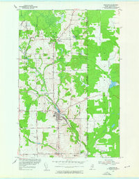
 1959 Woodstock1975 Print · USGSNorthern Maine and New Brunswick meet along the river valleys in the late fifties, showcasing an era of international rail and river commerce. Genealogists can trace family roots through border towns like Woodstock and Houlton, or along the lines of the Bangor & Aroostook railroad.
End of results
Showing maps 1-5 of 5
Top cities near Caswell
- Caribou historical maps
- Fort Fairfield historical maps
- Van Buren historical maps
- Washburn historical maps
- Limestone historical maps
- Woodland historical maps
See more
Frequently asked questions
- What are the different types of historical maps available for Caswell?
- What is the oldest map of Caswell?
- Where can I purchase historical maps of Caswell for my home or office?
- Where can I download high-res historical maps of Caswell?
- Are there historical topographic maps available for Caswell?
- Is there historical aerial imagery available for Caswell?
- Where are historical maps of Caswell sourced from?