1980s Maps of Linneus, Maine
Explore 6 historic maps of Linneus from the 1980s. These maps offer a rare glimpse into what life looked like during the 1980s — showing old roads, neighborhoods, homes, and landmarks that have changed or disappeared over time.
Whether you're researching your family's past, planning a metal detecting trip, or studying how Linneus's landscape evolved across the 1980s, these high-resolution maps are a powerful tool for exploring the history of this region.
- Focus on a specific era: All maps on this page are from the 1980s, giving you a focused view of this time period.
- See what’s changed: Compare century-old streets, trails, and buildings to today's modern landscape using overlays and satellite layers.
- Research with precision: Use these maps for genealogy, historical research, land use analysis, or educational projects.
- View, download, or print: Maps are fully viewable online in high resolution, and can be downloaded or printed for your own records.
Start exploring Linneus's history through authentic maps from the 1980s. This is your window into the past.
Linneus, ME maps
(6)- 1984 Map of Linneus, 1985 Print
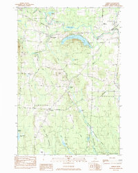 1984 Linneus1985 Print · USGSSouthern Aroostook County is shown here in the mid-1980s, revealing a landscape shaped by timber roads and the winding Meduxnekeag River. Genealogists and local historians can trace family-named sites like Porter Settlement, Adams Mtn, and the roads around New Limerick.
 - 1985 Map of Oakfield
 1985 Oakfield1985 Print · USGSAroostook County in the 1980s displays a balance between the timber-and-rail industry and the protected wilderness of the North Woods. Genealogists and local historians can trace family-named hubs like Smyrna Mills, Island Falls, and Knowles Corner along the Bangor and Aroostook railroad line.
 - 1985 Map of Millinocket, 1986 Print
 1985 Millinocket1986 Print · USGSThe North Maine Woods were a landscape of industrial timber and wilderness recreation in the mid-eighties. Genealogists and researchers can trace local settlements and rail stops like Sherman Mills, Wytopitlock, and the Old Long A Siding near the Penobscot River.2 unique versions available
 - 1986 Map of Meduxnekeag Lake
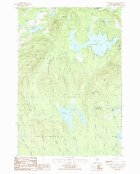 1986 Meduxnekeag Lake1986 Print · USGSAroostook County in the 1980s is mapped here across the townships of Smyrna and New Limerick, showing a landscape defined by glacial lakes and ridges. Genealogists and local historians can locate family landmarks like Bennett, Timoney, and the Cem near the Oakfield Hills.
 - 1989 Map of Monument Brook
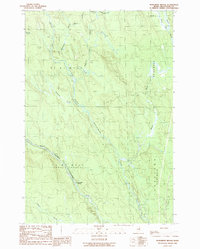 1989 Monument Brook1989 Print · USGSAroostook County's deep woods are documented here in the late eighties, showing the convergence of the Mattawamkeag River branches. Local historians can trace the remote City Camp Landing and the boundaries of the Bragg Tract.
 - 1989 Map of Tenmile Lake
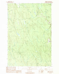 1989 Tenmile Lake1989 Print · USGSAroostook County was a landscape of remote settlements and complex wetlands in the late eighties. Genealogists and historians can trace family locations at Wilcox Settlement and Estabrook Settlement or explore the bogs surrounding Tenmile Lake.
End of results
Showing maps 1-6 of 6
Top cities near Linneus
- Houlton historical maps
- Hodgdon historical maps
- Littleton historical maps
- Island Falls historical maps
- Oakfield historical maps
- New Limerick historical maps
See more
Frequently asked questions
- What are the different types of historical maps available for Linneus?
- What is the oldest map of Linneus?
- Where can I purchase historical maps of Linneus for my home or office?
- Where can I download high-res historical maps of Linneus?
- Are there historical topographic maps available for Linneus?
- Is there historical aerial imagery available for Linneus?
- Where are historical maps of Linneus sourced from?