1900s (20th Century) Maps of Fournier, Madawaska
Explore 6 historic maps of Fournier from the 1900s (20th Century). These maps offer a rare glimpse into what life looked like during the 1900s — showing old roads, neighborhoods, homes, and landmarks that have changed or disappeared over time.
Whether you're researching your family's past, planning a metal detecting trip, or studying how Fournier's landscape evolved across the 1900s, these high-resolution maps are a powerful tool for exploring the history of this region.
- Focus on a specific era: All maps on this page are from the 1900s, giving you a focused view of this time period.
- See what’s changed: Compare century-old streets, trails, and buildings to today's modern landscape using overlays and satellite layers.
- Research with precision: Use these maps for genealogy, historical research, land use analysis, or educational projects.
- View, download, or print: Maps are fully viewable online in high resolution, and can be downloaded or printed for your own records.
Start exploring Fournier's history through authentic maps from the 1900s. This is your window into the past.
Fournier, Madawaska maps
(6)- 1932 Map of Frenchville
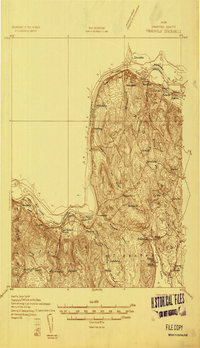 1932 Frenchville1932 Print · USGSAroostook County's international borderland and rail network are meticulously detailed in the early 1930s, showing the intersection of Maine and New Brunswick. Genealogists can trace numerous local landmarks including St David Ch, Dionne Corner, and a series of numbered rural schools like School No 15.2 unique versions available
 - 1935 Map of Frenchville
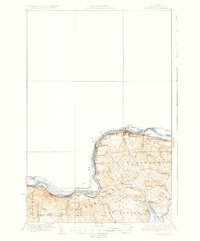 1935 Frenchville1935 Print · USGSUpper Aroostook County during the mid-1930s reveals a landscape shaped by the St. John River and the timber-and-farm economy. Researchers can trace the legacy of rural education and rail sidings through landmarks like Lincoln Sch, Pelletier Siding, and Dionne Corner.4 unique versions available
 - 1962 Map of Edmundston, 1966 Print
 1962 Edmundston1966 Print · USGSThe international borderlands of northern Maine and Canada come alive here during the early sixties, centered on the river-and-rail economies of the day. Genealogists and historians can trace the paths of the Bangor and Aroostook railroad through river towns like Fort Kent and St Agatha.2 unique versions available
 - 1975 Map of Frenchville SE, 1981 Print
 1975 Frenchville SE1981 Print · USGSThe international border along the St John River comes into sharp focus during the mid-1970s, capturing the industrial heart of the St. John Valley. Genealogists and local historians can trace the clearings and family-held land around Dionne Corner, Fournier, and the settlement at Cleveland.
 - 1986 Map of Madawaska
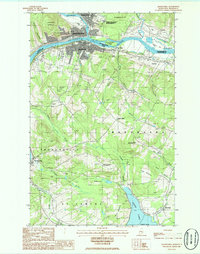 1986 Madawaska1986 Print · USGSThe international border at the St John River comes alive in the 1980s, showing the deep rail and river ties between Maine and New Brunswick. Genealogists can trace family landmarks like Dionne Corner and St Davids Ch (Rc) near the Bangor and Aroostook RR.
 - 1994 Map of Madawaska
 1994 Madawaska1994 Print · USGSThe St John Valley in the 1990s remained a unique cultural crossroads of Maine and New Brunswick, centered on the river and the rails. Genealogists and historians can trace family-named settlements like Violette Settlement or explore the shores of Eagle Lake and Long Lake.
End of results
Showing maps 1-6 of 6
Frequently asked questions
- What are the different types of historical maps available for Fournier?
- What is the oldest map of Fournier?
- Where can I purchase historical maps of Fournier for my home or office?
- Where can I download high-res historical maps of Fournier?
- Are there historical topographic maps available for Fournier?
- Is there historical aerial imagery available for Fournier?
- Where are historical maps of Fournier sourced from?