1980s Maps of Mars Hill, Maine
Explore 2 historic maps of Mars Hill from the 1980s. These maps offer a rare glimpse into what life looked like during the 1980s — showing old roads, neighborhoods, homes, and landmarks that have changed or disappeared over time.
Whether you're researching your family's past, planning a metal detecting trip, or studying how Mars Hill's landscape evolved across the 1980s, these high-resolution maps are a powerful tool for exploring the history of this region.
- Focus on a specific era: All maps on this page are from the 1980s, giving you a focused view of this time period.
- See what’s changed: Compare century-old streets, trails, and buildings to today's modern landscape using overlays and satellite layers.
- Research with precision: Use these maps for genealogy, historical research, land use analysis, or educational projects.
- View, download, or print: Maps are fully viewable online in high resolution, and can be downloaded or printed for your own records.
Start exploring Mars Hill's history through authentic maps from the 1980s. This is your window into the past.
Mars Hill, ME maps
(2)- 1984 Map of Westfield
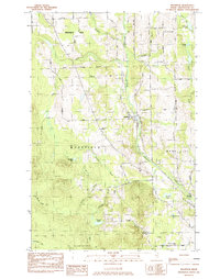 1984 Westfield1984 Print · USGSAroostook County in the early eighties was a landscape of rail-connected settlements and timberland. Genealogists and historians can trace the Bangor and Aroostook rail line, Marshall Cem, and many remote water bodies like Winslow Lake.
 - 1984 Map of Mars Hill, 1985 Print
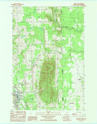 1984 Mars Hill1985 Print · USGSThe Maine-New Brunswick borderlands are captured here in the early 1980s, centered on the towering ridge of MARS HILL. Researchers can trace local history through the BANGOR AND AROOSTOOK rail line and sites like Kings Grove Cem, Listerville, and the Mackay Wing Sch.
End of results
Showing maps 1-2 of 2
Top cities near Mars Hill
- Presque Isle historical maps
- Caribou historical maps
- Fort Fairfield historical maps
- Mapleton historical maps
- Washburn historical maps
- Easton historical maps
See more
Top neighborhoods of Mars Hill
Frequently asked questions
- What are the different types of historical maps available for Mars Hill?
- What is the oldest map of Mars Hill?
- Where can I purchase historical maps of Mars Hill for my home or office?
- Where can I download high-res historical maps of Mars Hill?
- Are there historical topographic maps available for Mars Hill?
- Is there historical aerial imagery available for Mars Hill?
- Where are historical maps of Mars Hill sourced from?