Old Maps of Brunswick, Maine for Genealogy
Trace your family roots with 54 historic maps of Brunswick. These high-res maps reveal old neighborhoods, homesites, landmarks, and streets — helping you uncover where your ancestors lived and how the area evolved over time.
- Explore historic neighborhoods: Identify where your relatives may have lived in the 1800s or 1900s.
- Compare maps over time: Trace the changes in streets, buildings, and landmarks for multi-generational research.
- Perfect for genealogy & ancestry research: Used by family historians and researchers to map out lineage and migration.
These maps are an incredible resource for exploring your personal connection to Brunswick's past.
Brunswick, ME maps
(54)- 1892 Map of Freeport
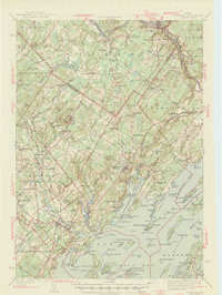
 1892 Freeport1892 Print · USGSCumberland County coastal life in the 1890s centered on the busy intersections of rail and tide. Genealogists and historians can trace the old shipping hubs at Mast Landing, the many islands of Casco Bay, and the rail corridors at Yarmouth Junction.9 unique versions available
 - 1894 Map of Bath
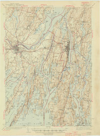
 1894 Bath1894 Print · USGSCoastal Maine at the height of the maritime era is captured in this survey of the river-linked communities of Bath and Brunswick. Genealogists and historians can trace the foundations of local shipping and rail at Winnegance, Parker Head, and along the M. C. R. R. lines.9 unique versions available
 - 1920 Map of Bath
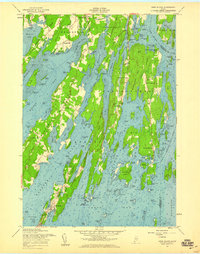
 1920 Bath1920 Print · USGSCoastal Maine at the height of the rail era is captured here, showing the intricate tidal waters surrounding Bath and Brunswick. Genealogists and local historians can trace family locations near Nequasset Falls, Cundy Harbor, and the Quaker church.2 unique versions available
 - 1941 Map of Freeport, 1957 Print
 1941 Freeport1957 Print · USGSCumberland County at the dawn of the 1940s shows a landscape defined by the Androscoggin River and the rugged shoreline of Casco Bay. Local researchers can trace family roots through numerous burial grounds like Elmlawn Cem or locate forgotten schoolhouses like Hacker Sch and Hicks Sch.
 - 1944 Map of Freeport
 1944 Freeport1944 Print · USGSCumberland County’s rugged shoreline and industrial river valleys are captured during the early 1940s, from the mills of the Androscoggin River to the islands of Casco Bay. Researchers can trace the legacy of local families through landmarks like Plummer Mill, Hacker Sch, and the Lunt Memorial Cem.3 unique versions available
 - 1945 Map of Bath
 1945 Bath1945 Print · USGSThe mid-coast Maine shoreline and Kennebec River shipping corridor are preserved here just as the war was ending. Genealogists and historians can trace the locations of family burial grounds like Winnegance Cem, rural schoolhouses like Littlefield Sch, and the industrial footprint of the Dana Mill.2 unique versions available
 - 1948 Map of Bath
 1948 Bath1948 Print · USGSMid-coast Maine’s intricate shoreline and island outposts are captured here just after the war. Researchers can trace historic maritime settlements from Bath to Friendship and locate remote landmarks like Monhegan Island and Pemaquid Point.2 unique versions available
 - 1949 Map of Portland
 1949 Portland1949 Print · USGSCoastal Maine and the New Hampshire interior are shown in detail during the late forties, from the bustling harbors to the lakeside villages. Researchers can trace historical rail networks like the Boston & Maine RR and locate coastal defenses such as Fort Preble.3 unique versions available
 - 1950 Map of Orrs Island
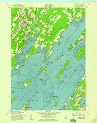
 1950 Orrs Island1950 Print · USGSCoastal Maine in the post-war era reveals an intricate network of island villages and saltwater coves. Genealogists can trace family-named points and landmarks like the Gun Point School, Harpswell Ch, and the fishing hub at Cundy Harbor.
 - 1956 Map of Portland, 1963 Print
 1956 Portland1963 Print · USGSSouthern Maine and eastern New Hampshire are captured here in the mid-fifties, during a time of major highway expansion and military growth. You can trace the path of the Maine Turnpike and locate landmarks like the Portsmouth Naval Shipyard and Sebago Lake.4 unique versions available
 - 1956 Map of Bath, 1974 Print
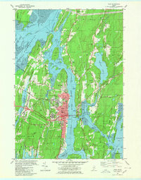
 1956 Bath1974 Print · USGSCoastal Maine in the mid-fifties reveals a landscape of deep-water harbors and island outposts as the region transitioned from industrial roots to a summer destination. Genealogists can trace maritime families in Boothbay Harbor, Tenants Harbor, and on remote Monhegan Island.
 - 1957 Map of Bath
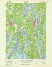
 1957 Bath1957 Print · USGSThe Maine coast in the mid-fifties is captured here, from the shipbuilding hubs of Bath and Brunswick to the granite reaches of Rockland. Researchers can trace the Maine Central RR line and remote island outposts like Monhegan Island and Matinicus Isle.
 - 1957 Map of Orrs Island, 1959 Print
 1957 Orrs Island1959 Print · USGSCoastal life in the late fifties centered on the interconnected islands and necks of Maine's shoreline. Genealogists and historians can trace family locations near Cundys Harbor, Orrs Island, and the Queen of the Mission Chapel.4 unique versions available
 - 1957 Map of Freeport, 1959 Print
 1957 Freeport1959 Print · USGSMid-century coastal Maine comes to life in this survey of the shoreline where the railroad meets the tide. Genealogists and researchers can trace local landmarks like Burr Cem, the South Freeport Ch, and the many islands of Casco Bay.3 unique versions available
 - 1957 Map of Bath, 1960 Print
 1957 Bath1960 Print · USGSThe mid-coast of Maine is captured here during a period of military and industrial growth along the Kennebec River. Genealogists and historians can trace the foundations of Bath and Brunswick, identifying family plots like Maple Grove Cem and the historic Bowdoin College campus.4 unique versions available
 - 1957 Map of Freeport, 1961 Print
 1957 Freeport1961 Print · USGSCoastal and rural Maine intersect in the late fifties as the turnpike begins to reshape the landscape from the Androscoggin River to Casco Bay. Genealogists can trace family names at Lunt Memorial Cem or explore the settlements of Shiloh and Durham Southwest Bend.3 unique versions available
 - 1958 Map of Bath
 1958 Bath1958 Print · USGSCoastal Maine in the late fifties reveals a landscape of industrial river towns and remote island outposts. Genealogists and historians can trace the Maine Central RR through Bath, explore the islands of Muscongus Bay, or locate seafaring families at Pemaquid Point.
 - 1959 Map of Portland
 1959 Portland1959 Print · USGSThe Maine and New Hampshire coastlines meet in this mid-century portrait of maritime commerce and inland rail networks. Researchers can trace the legacy of coastal defense at Fort Williams and follow the historic path of the Maine Central RR through the White Mountain National Forest.2 unique versions available
 - 1963 Map of Portland
 1963 Portland1963 Print · USGSCoastal Maine and New Hampshire thrived as maritime and industrial hubs during the mid-sixties, linked by a dense network of rail and river. Researchers can trace historic transit corridors like the Maine Central RR and locate key sites such as the Portsmouth Naval Shipyard or Pease Air Force Base.3 unique versions available
 - 1963 Map of Bath
 1963 Bath1963 Print · USGSThe Maine Midcoast in the early sixties remains a world of tidal rivers and jagged peninsulas tied to the sea. Genealogy and local history researchers can trace the rail lines of the Maine Central RR and locate offshore communities like Matinicus Island and Monhegan.2 unique versions available
 - 1965 Map of Bath
 1965 Bath1965 Print · USGSThe Midcoast Maine shoreline and its archipelago come alive in the mid-1960s, showing the region's deep reliance on river and rail. Researchers can trace historic harbor towns like Boothbay Harbor and Damariscotta, and locate coastal landmarks from Pemaquid Point to the Fort Popham Military Res.
 - 1979 Map of Lisbon Falls South
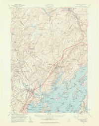
 1979 Lisbon Falls South1979 Print · USGSThe Androscoggin River valley in the late 1970s reveals a landscape of paper mill towns, rural crossroads, and family cemeteries. Genealogists and historians can locate heritage sites like Shiloh, Pejepscot, and the Lunt Memorial Cem along the Maine Central line.3 unique versions available
 - 1980 Map of Brunswick
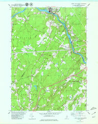
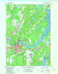 1980 Brunswick1980 Print · USGSCoastal Maine transitions from the academic halls of Brunswick to the tidal flats of Merrymeeting Bay in the early eighties. Genealogists and historians can trace family plots at Riverside Cem or locate the sprawling Brunswick Naval Air Station.3 unique versions available
 - 1980 Map of Bath
 1980 Bath1980 Print · USGSMid-coast Maine’s maritime heritage is on full display here in the early eighties, centered on the historic shipbuilding hub of BATH. Researchers can trace old family names at Oak Grove Cem or locate former school sites like Dike Sch and Morse High Sch.3 unique versions available
 - 1985 Map of Bath, 1986 Print
 1985 Bath1986 Print · USGSMidcoast Maine in the mid-eighties shows a landscape of deep-water harbors and strategic military installations. Researchers can trace the coastal rail lines of the Maine Central RR and locate landmarks from Popham Beach to the remote Monhegan Plantation.2 unique versions available
Showing maps 1-25 of 54
Top cities near Brunswick
- Portland historical maps
- Lewiston historical maps
- Auburn historical maps
- Falmouth historical maps
- Lisbon historical maps
- Yarmouth historical maps
See more
Top neighborhoods of Brunswick
- Harding historical maps
- Growstown historical maps
- Merepoint historical maps
- Merrymeeting Trailer Park historical maps
- Bunganuc Landing historical maps
- Hillside historical maps
See more
Frequently asked questions
- What are the different types of historical maps available for Brunswick?
- What is the oldest map of Brunswick?
- Where can I purchase historical maps of Brunswick for my home or office?
- Where can I download high-res historical maps of Brunswick?
- Are there historical topographic maps available for Brunswick?
- Is there historical aerial imagery available for Brunswick?
- Where are historical maps of Brunswick sourced from?