Old Maps of Bailey Island, Harpswell for Metal Detecting
Plan your next treasure hunt with 18 historic maps of Bailey Island. Find old homesites, ghost towns, trails, and gathering spots that may be lost to time — perfect for identifying promising metal detecting locations.
- Locate forgotten sites: Uncover places like long-lost settlements, abandoned rail lines, or gathering spots.
- Plan better hunts: Use map overlays combined with LiDAR or satellite views to narrow in on historically rich areas.
- Made for detectorists: Thousands of hobbyists use these maps to discover relics, coins, and hidden history.
Use these historic maps to boost your research and find new opportunities beneath the surface of Bailey Island.
Bailey Island, Harpswell maps
(18)- 1893 Map of Small Point
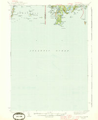
 1893 Small Point1893 Print · USGSCoastal Maine in the late nineteenth century is charted here with precision, showing the dangerous ledges and vital harbors of the Casco Bay region. Maritime researchers can locate Seguin Light, Pond Id. Light, and family-named landmarks like Wallace Head.5 unique versions available
 - 1919 Map of Small Point
 1919 Small Point1919 Print · USGSThe Maine coastline at the mouth of the Kennebec is captured in this era of transition, detailing the rocky islands and harbors of the outer Casco Bay. Genealogists and maritime historians can trace coastal settlements at Popham Beach and Bailey Island, or locate landmarks like Seguin Light and Small Pt Harbor.
 - 1944 Map of Small Point
 1944 Small Point1944 Print · USGSThe Maine coastline during the early 1940s reveals a maritime landscape of isolated peninsulas and island fishing communities. Genealogists and coastal historians can trace the foundations of Popham Beach, explore the landing at West Point, and locate family landmarks from Bailey Island to Morse Mountain.3 unique versions available
 - 1948 Map of Bath
 1948 Bath1948 Print · USGSMid-coast Maine’s intricate shoreline and island outposts are captured here just after the war. Researchers can trace historic maritime settlements from Bath to Friendship and locate remote landmarks like Monhegan Island and Pemaquid Point.2 unique versions available
 - 1950 Map of Bailey Island
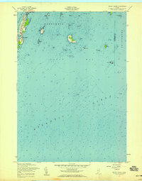
 1950 Bailey Island1950 Print · USGSThe Harpswell islands and the Casco Bay coastline are captured in the mid-1940s, showing a landscape defined by maritime navigation. Trace family landmarks and old harbor sites near Mackerel Cove, David Castle, and the isolated Ragged Island.
 - 1956 Map of Bath, 1974 Print
 1956 Bath1974 Print · USGSCoastal Maine in the mid-fifties reveals a landscape of deep-water harbors and island outposts as the region transitioned from industrial roots to a summer destination. Genealogists can trace maritime families in Boothbay Harbor, Tenants Harbor, and on remote Monhegan Island.
 - 1957 Map of Bath
 1957 Bath1957 Print · USGSThe Maine coast in the mid-fifties is captured here, from the shipbuilding hubs of Bath and Brunswick to the granite reaches of Rockland. Researchers can trace the Maine Central RR line and remote island outposts like Monhegan Island and Matinicus Isle.
 - 1957 Map of Bailey Island, 1959 Print
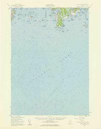
 1957 Bailey Island1959 Print · USGSCoastal Harpswell at the mid-century reveals the intimate connection between the land and the Atlantic. Genealogists and historians can trace the shoreline of Bailey Island and Orrs Island, locating landmarks like Mackerel Cove and the Jamison Ledge Beacon.3 unique versions available
 - 1957 Map of Small Point, 1960 Print
 1957 Small Point1960 Print · USGSThe Phippsburg peninsula and Harpswell islands are shown in detail during the late fifties, capturing the area's coastal defense and maritime heritage. Researchers can trace the layout of Fort Baldwin, the summer settlement at Popham Beach, and the landmarks of Bailey Island.4 unique versions available
 - 1958 Map of Bath
 1958 Bath1958 Print · USGSCoastal Maine in the late fifties reveals a landscape of industrial river towns and remote island outposts. Genealogists and historians can trace the Maine Central RR through Bath, explore the islands of Muscongus Bay, or locate seafaring families at Pemaquid Point.
 - 1963 Map of Bath
 1963 Bath1963 Print · USGSThe Maine Midcoast in the early sixties remains a world of tidal rivers and jagged peninsulas tied to the sea. Genealogy and local history researchers can trace the rail lines of the Maine Central RR and locate offshore communities like Matinicus Island and Monhegan.2 unique versions available
 - 1965 Map of Bath
 1965 Bath1965 Print · USGSThe Midcoast Maine shoreline and its archipelago come alive in the mid-1960s, showing the region's deep reliance on river and rail. Researchers can trace historic harbor towns like Boothbay Harbor and Damariscotta, and locate coastal landmarks from Pemaquid Point to the Fort Popham Military Res.
 - 1985 Map of Bath, 1986 Print
 1985 Bath1986 Print · USGSMidcoast Maine in the mid-eighties shows a landscape of deep-water harbors and strategic military installations. Researchers can trace the coastal rail lines of the Maine Central RR and locate landmarks from Popham Beach to the remote Monhegan Plantation.2 unique versions available
 - 2011 Map of Bailey Island, 2011 Print
 2011 Bailey Island2011 Print · USGSCovers Bailey Island, including Harpswell, Phippsburg, and other nearby areas
 - 2014 Map of Bailey Island, 2014 Print
 2014 Bailey Island2014 Print · USGSCovers Bailey Island, including Harpswell, Phippsburg, and other nearby areas
 - 2018 Map of Bailey Island, 2018 Print
 2018 Bailey Island2018 Print · USGSCovers Bailey Island, including Harpswell, Phippsburg, and other nearby areas
 - 2021 Map of Bailey Island, 2021 Print
 2021 Bailey Island2021 Print · USGSCovers Bailey Island, including Harpswell, Phippsburg, and other nearby areas
 - 2024 Map of Bailey Island, 2024 Print
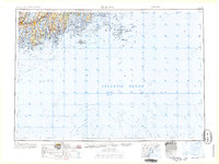
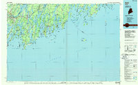
 2024 Bailey Island2024 Print · USGSCumberland County's rocky coastline is shown in great detail during the early 2020s, focusing on the islands and ledges south of Harpswell. Researchers can trace local landmarks like Bailey Island Cem and coastal features from Mackerel Cove to Ragged Island.
End of results
Showing maps 1-18 of 18
Top cities near Bailey Island
- Portland historical maps
- South Portland historical maps
- Scarborough historical maps
- Brunswick historical maps
- Falmouth historical maps
- Cape Elizabeth historical maps
See more
Frequently asked questions
- What are the different types of historical maps available for Bailey Island?
- What is the oldest map of Bailey Island?
- Where can I purchase historical maps of Bailey Island for my home or office?
- Where can I download high-res historical maps of Bailey Island?
- Are there historical topographic maps available for Bailey Island?
- Is there historical aerial imagery available for Bailey Island?
- Where are historical maps of Bailey Island sourced from?