
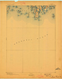
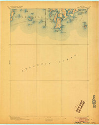
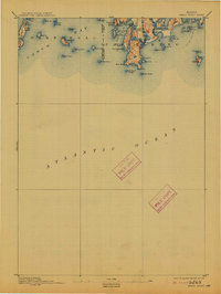
1893 Map of Small Point
USGS Topo · Published 1893About this map
Pond Id. Light and Seguin Light anchor this maritime survey of the Maine coastline, marking the entrance to the intricate waterways of the Midcoast region. The topography captures the jagged interface of the Atlantic Ocean and Casco Bay, where the transition from open sea to sheltered harbors is defined by landmarks like Small Point and Bailey Island. The drainage patterns of the Sprague River and Morse River illustrate the coastal marshlands, while numerous landforms such as Carrying Place Head and Bald Head reveal the exposed geography of the era.
Find a feature on this map
56 named features on this map. Tap any name to fly to it.
Don’t see what you’re looking for? This feature index may not catch every label — zoom into the map to look around manually.
Map Details
Editions of this 1893 Small Point Map
5 editions found
Historical Maps of Portland Through Time
150 maps found

1892 Freeport
Cumberland County, ME

1893 Casco Bay
Cumberland County, ME

1893 Small Point
Cumberland County, ME

1894 Gray
Cumberland County, ME

1896 Sebago
Cumberland County, ME

1898 Gray
Cumberland County, ME

1914 Casco Bay
Cumberland County, ME

1916 Casco Bay
Cumberland County, ME

1919 Small Point
Cumberland County, ME

1941 Casco Bay
Cumberland County, ME

1941 Freeport
Cumberland County, ME

1942 Gray
Cumberland County, ME

1942 Sebago Lake
Cumberland County, ME

1943 Sebago Lake
Cumberland County, ME

1944 Cape Elizabeth
Cumberland County, ME

1944 Freeport
Cumberland County, ME

1944 Gorham
Cumberland County, ME

1944 Gray
Cumberland County, ME

1944 Portland East
Cumberland County, ME

1944 Portland West
Cumberland County, ME

1944 Prouts Neck
Cumberland County, ME

1944 Small Point
Cumberland County, ME

1944 South Harpswell
Cumberland County, ME

1948 Portland West
Cumberland County, ME

1950 Bailey Island
Cumberland County, ME

1950 Gorham
Cumberland County, ME

1950 Orrs Island
Cumberland County, ME

1956 Portland East
Cumberland County, ME

1956 Portland West
Cumberland County, ME

1956 South Harpswell
Cumberland County, ME

1957 Bailey Island
Cumberland County, ME

1957 Cape Elizabeth
Cumberland County, ME

1957 Casco Bay
Cumberland County, ME

1957 Freeport
Cumberland County, ME

1957 Freeport
Cumberland County, ME

1957 Gorham
Cumberland County, ME

1957 Gray
Cumberland County, ME

1957 Orrs Island
Cumberland County, ME

1957 Prouts Neck
Cumberland County, ME

1957 Small Point
Cumberland County, ME

1957 Yarmouth
Cumberland County, ME

1959 Prouts Neck
Cumberland County, ME

1975 Gorham
Cumberland County, ME

1975 Prouts Neck
Cumberland County, ME

1979 Lisbon Falls South
Cumberland County, ME

1979 North Pownal
Cumberland County, ME

1980 Gray
Cumberland County, ME

1981 Raymond
Cumberland County, ME

1983 Bridgton
Cumberland County, ME

1983 Casco
Cumberland County, ME

1983 Naples
Cumberland County, ME

1983 North Sebago
Cumberland County, ME

1983 Sebago Lake
Cumberland County, ME

1997 Orrs Island
Cumberland County, ME

2000 Bridgton
Cumberland County, ME

2011 Bailey Island
Cumberland County, ME

2011 Bridgton
Cumberland County, ME

2011 Cape Elizabeth
Cumberland County, ME

2011 Casco
Cumberland County, ME

2011 Freeport
Cumberland County, ME

2011 Gorham
Cumberland County, ME

2011 Gray
Cumberland County, ME

2011 Lisbon Falls South
Cumberland County, ME

2011 Naples
Cumberland County, ME

2011 North Pownal
Cumberland County, ME

2011 North Sebago
Cumberland County, ME

2011 Orrs Island
Cumberland County, ME

2011 Portland East
Cumberland County, ME

2011 Portland West
Cumberland County, ME

2011 Prouts Neck
Cumberland County, ME

2011 Raymond
Cumberland County, ME

2011 Sebago Lake
Cumberland County, ME

2011 South Harpswell
Cumberland County, ME

2011 Yarmouth
Cumberland County, ME

2014 Bailey Island
Cumberland County, ME

2014 Bridgton
Cumberland County, ME

2014 Cape Elizabeth
Cumberland County, ME

2014 Casco
Cumberland County, ME

2014 Freeport
Cumberland County, ME

2014 Gorham
Cumberland County, ME

2014 Gray
Cumberland County, ME

2014 Lisbon Falls South
Cumberland County, ME

2014 Naples
Cumberland County, ME

2014 North Pownal
Cumberland County, ME

2014 North Sebago
Cumberland County, ME

2014 Orrs Island
Cumberland County, ME

2014 Portland East
Cumberland County, ME

2014 Portland West
Cumberland County, ME

2014 Prouts Neck
Cumberland County, ME

2014 Raymond
Cumberland County, ME

2014 Sebago Lake
Cumberland County, ME

2014 South Harpswell
Cumberland County, ME

2014 Yarmouth
Cumberland County, ME

2018 Bailey Island
Cumberland County, ME

2018 Bridgton
Cumberland County, ME

2018 Cape Elizabeth
Cumberland County, ME

2018 Casco
Cumberland County, ME

2018 Freeport
Cumberland County, ME

2018 Gorham
Cumberland County, ME

2018 Gray
Cumberland County, ME

2018 Lisbon Falls South
Cumberland County, ME

2018 Naples
Cumberland County, ME

2018 North Pownal
Cumberland County, ME

2018 North Sebago
Cumberland County, ME

2018 Orrs Island
Cumberland County, ME

2018 Portland East
Cumberland County, ME

2018 Portland West
Cumberland County, ME

2018 Prouts Neck
Cumberland County, ME

2018 Raymond
Cumberland County, ME

2018 Sebago Lake
Cumberland County, ME

2018 South Harpswell
Cumberland County, ME

2018 Yarmouth
Cumberland County, ME

2021 Bailey Island
Cumberland County, ME

2021 Bridgton
Cumberland County, ME

2021 Cape Elizabeth
Cumberland County, ME

2021 Casco
Cumberland County, ME

2021 Freeport
Cumberland County, ME

2021 Gorham
Cumberland County, ME

2021 Gray
Cumberland County, ME

2021 Lisbon Falls South
Cumberland County, ME

2021 Naples
Cumberland County, ME

2021 North Pownal
Cumberland County, ME

2021 North Sebago
Cumberland County, ME

2021 Orrs Island
Cumberland County, ME

2021 Portland East
Cumberland County, ME

2021 Portland West
Cumberland County, ME

2021 Prouts Neck
Cumberland County, ME

2021 Raymond
Cumberland County, ME

2021 Sebago Lake
Cumberland County, ME

2021 South Harpswell
Cumberland County, ME

2021 Yarmouth
Cumberland County, ME

2024 Bailey Island
Cumberland County, ME

2024 Bridgton
Cumberland County, ME

2024 Cape Elizabeth
Cumberland County, ME

2024 Casco
Cumberland County, ME

2024 Freeport
Cumberland County, ME

2024 Gorham
Cumberland County, ME

2024 Gray
Cumberland County, ME

2024 Lisbon Falls South
Cumberland County, ME

2024 Naples
Cumberland County, ME

2024 North Pownal
Cumberland County, ME

2024 North Sebago
Cumberland County, ME

2024 Orrs Island
Cumberland County, ME

2024 Portland East
Cumberland County, ME

2024 Portland West
Cumberland County, ME

2024 Prouts Neck
Cumberland County, ME

2024 Raymond
Cumberland County, ME

2024 Sebago Lake
Cumberland County, ME

2024 South Harpswell
Cumberland County, ME

2024 Yarmouth
Cumberland County, ME