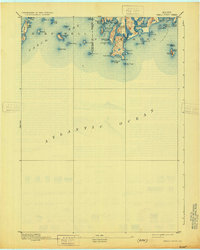
1893 Map of Small Point
USGS Topo · Published 1931About this map
Phippsburg and the surrounding islands of Casco Bay are depicted here during the late nineteenth century, showing a maritime landscape defined by rocky ledges and isolated outposts. Navigational aids like the Pond Id. Light and Seguin Light stand as critical landmarks for vessels transiting the Gulf of Maine. The coastline of Small Point is intricately detailed, revealing the tight clusters of topography around Head Beach and the sheltered waters of Carrying Place Cove. On the land, a Mill at Mill Pt. suggests the local industry that once thrived alongside the fishing and shipping trades.
Find a feature on this map
49 named features on this map. Tap any name to fly to it.
Don’t see what you’re looking for? This feature index may not catch every label — zoom into the map to look around manually.
Map Details
Editions of this 1893 Small Point Map
5 editions found
Other maps of this area

1892 · Freeport
USGS Topo · 1:62,500

1893 · Small Point
USGS Topo · 1:62,500

1893 · Casco Bay
USGS Topo · 1:62,500

1893 · Boothbay
USGS Topo · 1:62,500

1894 · Bath
USGS Topo · 1:62,500

1914 · Casco Bay
USGS Topo · 1:48,000

1916 · Casco Bay
USGS Topo · 1:62,500

1916 · Portland And Vicinity
USGS Topo · 1:62,500

1918 · Portland And Vicinity
USGS Topo · 1:62,500

1919 · Small Point
USGS Topo · 1:62,500