1893 Map of Small Point
USGS Topo · Published 1905About this map
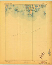
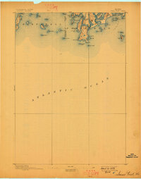
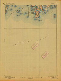
Seguin Light and Pond Id. Light stand as critical navigational markers along this coastal stretch of Maine, where the Atlantic Ocean meets a complex network of islands and inlets. At the end of the nineteenth century, the maritime geography of Phippsburg and Harpswell is defined by isolated settlements such as Bailey Island and the seaside enclave of Popham Beach. The land is fragmented into numerous islands including Orr Id., Ragged Id., and Stage Id., illustrating the intricate shoreline that shaped local life. Notable coastal features such as Goose Id. Mill Pr. and Carrying Place Cove suggest early centers of activity and traditional transit points across the narrow necks of land. This survey, conducted by the U.S. Geological Survey under Director J.W. Powell, records the precise topography of the Sagadahoc and Cumberland County coastlines before modern development altered these historic fishing and seafaring communities.
Find a feature on this map
53 named features on this map. Tap any name to fly to it.
Don’t see what you’re looking for? This feature index may not catch every label — zoom into the map to look around manually.
Map Details
Editions of this 1893 Small Point Map
5 editions found

Other maps of this area

1892 · Freeport
USGS Topo · 1:62,500

1893 · Small Point
USGS Topo · 1:62,500

1893 · Casco Bay
USGS Topo · 1:62,500

1893 · Boothbay
USGS Topo · 1:62,500

1894 · Bath
USGS Topo · 1:62,500

1914 · Casco Bay
USGS Topo · 1:48,000

1916 · Casco Bay
USGS Topo · 1:62,500

1916 · Portland And Vicinity
USGS Topo · 1:62,500

1918 · Portland And Vicinity
USGS Topo · 1:62,500

1919 · Small Point
USGS Topo · 1:62,500