1950s Maps of Portland, Maine
Explore 12 historic maps of Portland from the 1950s. These maps offer a rare glimpse into what life looked like during the 1950s — showing old roads, neighborhoods, homes, and landmarks that have changed or disappeared over time.
Whether you're researching your family's past, planning a metal detecting trip, or studying how Portland's landscape evolved across the 1950s, these high-resolution maps are a powerful tool for exploring the history of this region.
- Focus on a specific era: All maps on this page are from the 1950s, giving you a focused view of this time period.
- See what’s changed: Compare century-old streets, trails, and buildings to today's modern landscape using overlays and satellite layers.
- Research with precision: Use these maps for genealogy, historical research, land use analysis, or educational projects.
- View, download, or print: Maps are fully viewable online in high resolution, and can be downloaded or printed for your own records.
Start exploring Portland's history through authentic maps from the 1950s. This is your window into the past.
Portland, ME maps
(12)- 1956 Map of Portland East, 1958 Print
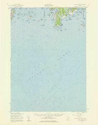
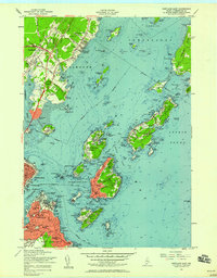 1956 Portland East1958 Print · USGSCasco Bay and its island communities are captured here in the mid-fifties as coastal Maine's military and residential landscapes evolved. Researchers can trace historic harbor defenses at Fort McKinley and locate family landmarks from Waites Landing to the Pine Grove Sch.5 unique versions available
 - 1956 Map of Portland West, 1958 Print
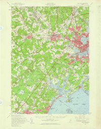
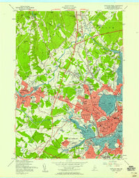 1956 Portland West1958 Print · USGSGreater Portland and Westbrook are seen here during the mid-century peak of their rail and river industries. Genealogists and historians can trace neighborhood growth through local schools like Longfellow Sch, industrial sites along the Fore River, and numerous burial grounds including Evergreen Cemetery.6 unique versions available
 - 1956 Map of South Harpswell, 1959 Print
 1956 South Harpswell1959 Print · USGSThe islands and sounds of Casco Bay come alive in this mid-century survey of the Cumberland County coast. Genealogists and coastal historians can trace the landings and homesteads of South Harpswell or locate landmarks like Halfway Rock and the Observation Tower on Jewell Island.3 unique versions available
 - 1956 Map of Portland, 1963 Print
 1956 Portland1963 Print · USGSSouthern Maine and eastern New Hampshire are captured here in the mid-fifties, during a time of major highway expansion and military growth. You can trace the path of the Maine Turnpike and locate landmarks like the Portsmouth Naval Shipyard and Sebago Lake.4 unique versions available
 - 1956 Map of Bath, 1974 Print
 1956 Bath1974 Print · USGSCoastal Maine in the mid-fifties reveals a landscape of deep-water harbors and island outposts as the region transitioned from industrial roots to a summer destination. Genealogists can trace maritime families in Boothbay Harbor, Tenants Harbor, and on remote Monhegan Island.
 - 1957 Map of Bath
 1957 Bath1957 Print · USGSThe Maine coast in the mid-fifties is captured here, from the shipbuilding hubs of Bath and Brunswick to the granite reaches of Rockland. Researchers can trace the Maine Central RR line and remote island outposts like Monhegan Island and Matinicus Isle.
 - 1957 Map of Cape Elizabeth, 1958 Print
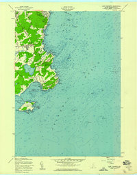 1957 Cape Elizabeth1958 Print · USGSCoastal Cumberland County comes into sharp focus during the late 1950s as residential growth meets maritime tradition along Casco Bay. Trace family sites near Delano Park, the strategic grounds of Fort Williams, and the rugged shoreline from Peabbles Point to Richmond Island.3 unique versions available
 - 1957 Map of Small Point, 1960 Print
 1957 Small Point1960 Print · USGSThe Phippsburg peninsula and Harpswell islands are shown in detail during the late fifties, capturing the area's coastal defense and maritime heritage. Researchers can trace the layout of Fort Baldwin, the summer settlement at Popham Beach, and the landmarks of Bailey Island.4 unique versions available
 - 1957 Map of Casco Bay, 1960 Print
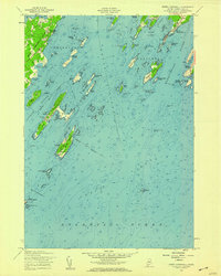
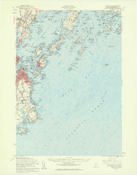 1957 Casco Bay1960 Print · USGSThe Maine coast near Portland appears here in the late fifties, featuring a landscape defined by historic harbor defenses and island communities. Genealogists and historians can trace rail lines like the Grand Trunk or locate landmarks such as the Maine School for the Deaf and Fort Williams Military Res.3 unique versions available
 - 1957 Map of Portland, 1960 Print
 1957 Portland1960 Print · USGSCoastal Maine during the mid-fifties shows the transition from historic maritime centers to the suburban era. Researchers can trace family roots through numerous sites like Evergreen Cem, Thornton Academy, and the State Reformatory for Men.3 unique versions available
 - 1958 Map of Bath
 1958 Bath1958 Print · USGSCoastal Maine in the late fifties reveals a landscape of industrial river towns and remote island outposts. Genealogists and historians can trace the Maine Central RR through Bath, explore the islands of Muscongus Bay, or locate seafaring families at Pemaquid Point.
 - 1959 Map of Portland
 1959 Portland1959 Print · USGSThe Maine and New Hampshire coastlines meet in this mid-century portrait of maritime commerce and inland rail networks. Researchers can trace the legacy of coastal defense at Fort Williams and follow the historic path of the Maine Central RR through the White Mountain National Forest.2 unique versions available
End of results
Showing maps 1-12 of 12
Top cities near Portland
- South Portland historical maps
- Biddeford historical maps
- Scarborough historical maps
- Brunswick historical maps
- Westbrook historical maps
- Saco historical maps
See more
Top neighborhoods of Portland
- McKinley Estates historical maps
- Peaks Island historical maps
- Cliff Island historical maps
- Great Diamond Island Landing historical maps
- Cushing Island historical maps
- Donatelli Square historical maps
See more
Frequently asked questions
- What are the different types of historical maps available for Portland?
- What is the oldest map of Portland?
- Where can I purchase historical maps of Portland for my home or office?
- Where can I download high-res historical maps of Portland?
- Are there historical topographic maps available for Portland?
- Is there historical aerial imagery available for Portland?
- Where are historical maps of Portland sourced from?