1920s Maps of Kingfield, Maine
Explore 3 historic maps of Kingfield from the 1920s. These maps offer a rare glimpse into what life looked like during the 1920s — showing old roads, neighborhoods, homes, and landmarks that have changed or disappeared over time.
Whether you're researching your family's past, planning a metal detecting trip, or studying how Kingfield's landscape evolved across the 1920s, these high-resolution maps are a powerful tool for exploring the history of this region.
- Focus on a specific era: All maps on this page are from the 1920s, giving you a focused view of this time period.
- See what’s changed: Compare century-old streets, trails, and buildings to today's modern landscape using overlays and satellite layers.
- Research with precision: Use these maps for genealogy, historical research, land use analysis, or educational projects.
- View, download, or print: Maps are fully viewable online in high resolution, and can be downloaded or printed for your own records.
Start exploring Kingfield's history through authentic maps from the 1920s. This is your window into the past.
Kingfield, ME maps
(3)- 1928 Map of Dead River
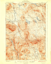 1928 Dead River1928 Print · USGSThe Somerset County wilderness in the mid-twenties is captured here as a landscape of isolated plantations and mountain trails. Genealogists and historians can trace the remote Dead River School and family sites like Joe Farm or the East Carry (Carry Pond P O).6 unique versions available
 - 1928 Map of Stratton
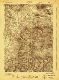 1928 Stratton1928 Print · USGSThe village of Flagstaff and the Dead River valley appear here in the late 1920s, just decades before the landscape was transformed by damming. You can trace the original valley settlements and landmarks like Morgan Farm, Cathedral Pines, and Morgan Camp.3 unique versions available
 - 1929 Map of Phillips
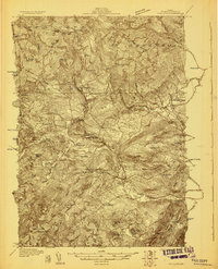 1929 Phillips1929 Print · USGSFranklin County in the late 1920s is captured here as a network of mountain hamlets and valley mills centered on the Phillips hub. Genealogists and historians can trace defunct schoolhouses like Butterfield Sch and old rail stops at Perham Junction or Madrid Junction.3 unique versions available
End of results
Showing maps 1-3 of 3
Top cities near Kingfield
- Farmington historical maps
- Anson historical maps
- Strong historical maps
- Embden historical maps
- Phillips historical maps
- Industry historical maps
See more
Top neighborhoods of Kingfield
Frequently asked questions
- What are the different types of historical maps available for Kingfield?
- What is the oldest map of Kingfield?
- Where can I purchase historical maps of Kingfield for my home or office?
- Where can I download high-res historical maps of Kingfield?
- Are there historical topographic maps available for Kingfield?
- Is there historical aerial imagery available for Kingfield?
- Where are historical maps of Kingfield sourced from?