1930s Maps of Kingfield, Maine
Explore 5 historic maps of Kingfield from the 1930s. These maps offer a rare glimpse into what life looked like during the 1930s — showing old roads, neighborhoods, homes, and landmarks that have changed or disappeared over time.
Whether you're researching your family's past, planning a metal detecting trip, or studying how Kingfield's landscape evolved across the 1930s, these high-resolution maps are a powerful tool for exploring the history of this region.
- Focus on a specific era: All maps on this page are from the 1930s, giving you a focused view of this time period.
- See what’s changed: Compare century-old streets, trails, and buildings to today's modern landscape using overlays and satellite layers.
- Research with precision: Use these maps for genealogy, historical research, land use analysis, or educational projects.
- View, download, or print: Maps are fully viewable online in high resolution, and can be downloaded or printed for your own records.
Start exploring Kingfield's history through authentic maps from the 1930s. This is your window into the past.
Kingfield, ME maps
(5)- 1930 Map of Kingfield
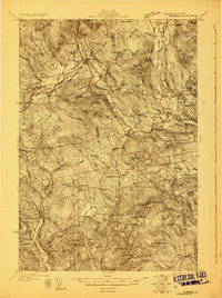 1930 Kingfield1930 Print · USGSThe Kingfield region and the western Maine highlands are captured here in the early 1930s. Genealogists can locate family homesteads near numerous district schools like Guild Sch and Hardy Sch, or trace the old roads through New Vineyard and Strong.4 unique versions available
 - 1931 Map of Dead River
 1931 Dead River1931 Print · USGSSomerset and Franklin counties in the mid-1920s show a landscape of remote plantations and traditional woodsman outposts. Genealogists and historians can trace localized landmarks like the Dead River School, the East Carry (Carry Pond PO) Pond, and Joe Farm.
 - 1932 Map of Phillips
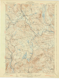
 1932 Phillips1932 Print · USGSFranklin County's mountain-and-valley landscape is captured here in the late twenties, centered on the Sandy River rail corridor. Trace the path of the Rangeley Lakes and Berlin Mills RR past old schoolhouses like Cushman Sch and Avon Valley Sch.4 unique versions available
 - 1932 Map of Stratton
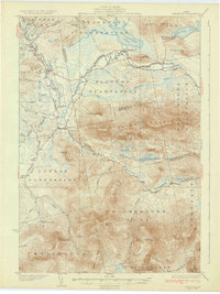 1932 Stratton1932 Print · USGSThe northern Maine woods in the late twenties and early thirties are captured here during a time of river-driven logging and remote plantation life. Local historians can trace the foundations of Eustis, the original layout of Flagstaff Pond, and rural schoolhouses like Browns Sch.3 unique versions available
 - 1932 Map of Kingfield
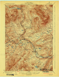
 1932 Kingfield1932 Print · USGSThe western Maine mountains in the early thirties are defined here by narrow-gauge rail lines and a network of river-valley settlements. Genealogists can locate numerous rural schools and family landmarks like Soule Mill, Starbird Sch, and Dyer Hill.3 unique versions available
End of results
Showing maps 1-5 of 5
Top cities near Kingfield
- Farmington historical maps
- Anson historical maps
- Strong historical maps
- Embden historical maps
- Phillips historical maps
- Industry historical maps
See more
Top neighborhoods of Kingfield
Frequently asked questions
- What are the different types of historical maps available for Kingfield?
- What is the oldest map of Kingfield?
- Where can I purchase historical maps of Kingfield for my home or office?
- Where can I download high-res historical maps of Kingfield?
- Are there historical topographic maps available for Kingfield?
- Is there historical aerial imagery available for Kingfield?
- Where are historical maps of Kingfield sourced from?