1980s Maps of Bar Harbor, Maine
Explore 7 historic maps of Bar Harbor from the 1980s. These maps offer a rare glimpse into what life looked like during the 1980s — showing old roads, neighborhoods, homes, and landmarks that have changed or disappeared over time.
Whether you're researching your family's past, planning a metal detecting trip, or studying how Bar Harbor's landscape evolved across the 1980s, these high-resolution maps are a powerful tool for exploring the history of this region.
- Focus on a specific era: All maps on this page are from the 1980s, giving you a focused view of this time period.
- See what’s changed: Compare century-old streets, trails, and buildings to today's modern landscape using overlays and satellite layers.
- Research with precision: Use these maps for genealogy, historical research, land use analysis, or educational projects.
- View, download, or print: Maps are fully viewable online in high resolution, and can be downloaded or printed for your own records.
Start exploring Bar Harbor's history through authentic maps from the 1980s. This is your window into the past.
Bar Harbor, ME maps
(7)- 1981 Map of Salsbury Cove
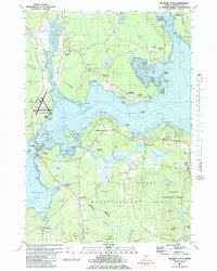 1981 Salsbury Cove1981 Print · USGSHancock County's coastline meets the northern reaches of Mount Desert Island in the early 1980s. Local researchers can trace family landmarks and coastal hamlets like Salsbury Cove, Lamoine Corner, and the rural Mtn View Ch.2 unique versions available
 - 1981 Map of Bartlett Island, 1982 Print
 1981 Bartlett Island1982 Print · USGSMount Desert Island's western coastline and the surrounding islands of Blue Hill Bay are captured here in the early eighties. Local historians can trace family names and early sites at Kelleytown, St Andrew by the Lake Ch, and the Murphy Cem.
 - 1981 Map of Newbury Neck, 1982 Print
 1981 Newbury Neck1982 Print · USGSCoastal Hancock County at the start of the 1980s reveals a landscape of wooded peninsulas and traditional shoreline communities. Genealogists can locate family burial grounds like Whittemore Cem and trace old roads through South Surry and West Trenton.
 - 1982 Map of Bar Harbor, 1983 Print
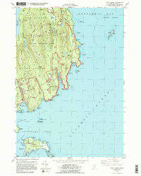
 1982 Bar Harbor1983 Print · USGSCoastal Maine in the early eighties reveals a bustling maritime landscape centered on the Bar Harbor waterfront and the protected lands of Acadia National Park. Genealogists and historians can trace local landmarks like the Holy Redeemer Ch, the Bragdon Cem, and the old Sorrento Sch.2 unique versions available
 - 1983 Map of Southwest Harbor
 1983 Southwest Harbor1983 Print · USGSMount Desert Island's dramatic coastal landscape is captured here in the early eighties, showing the maritime hubs of Southwest Harbor and Northeast Harbor before modern expansion. Genealogists can locate family landmarks like Union Cem and Richardson Cem or trace the historic grounds of Asticou.
 - 1983 Map of Seal Harbor
 1983 Seal Harbor1983 Print · USGSMount Desert Island's rugged coast is documented in the early 1980s, from the summit of Cadillac Mountain to the outlying Cranberry Isles. Trace island life and history at Islesford, the Lighthouse at Egg Rock, and the seasonal hub of Seal Harbor.2 unique versions available
 - 1985 Map of Bar Harbor
 1985 Bar Harbor1985 Print · USGSCoastal Hancock County in the mid-eighties shows an intricate landscape of island communities and protected wilderness. Trace the boundaries of Acadia National Park or locate seafaring hubs like Stonington and Bar Harbor.2 unique versions available
End of results
Showing maps 1-7 of 7
Top cities near Bar Harbor
- Ellsworth historical maps
- Blue Hill historical maps
- Hancock historical maps
- Mount Desert historical maps
- Southwest Harbor historical maps
- Lamoine historical maps
See more
Top neighborhoods of Bar Harbor
- Salsbury Cove historical maps
- Hulls Cove historical maps
- Town Hill historical maps
- Eden historical maps
Frequently asked questions
- What are the different types of historical maps available for Bar Harbor?
- What is the oldest map of Bar Harbor?
- Where can I purchase historical maps of Bar Harbor for my home or office?
- Where can I download high-res historical maps of Bar Harbor?
- Are there historical topographic maps available for Bar Harbor?
- Is there historical aerial imagery available for Bar Harbor?
- Where are historical maps of Bar Harbor sourced from?