1980s Maps of Blue Hill, Maine
Explore 9 historic maps of Blue Hill from the 1980s. These maps offer a rare glimpse into what life looked like during the 1980s — showing old roads, neighborhoods, homes, and landmarks that have changed or disappeared over time.
Whether you're researching your family's past, planning a metal detecting trip, or studying how Blue Hill's landscape evolved across the 1980s, these high-resolution maps are a powerful tool for exploring the history of this region.
- Focus on a specific era: All maps on this page are from the 1980s, giving you a focused view of this time period.
- See what’s changed: Compare century-old streets, trails, and buildings to today's modern landscape using overlays and satellite layers.
- Research with precision: Use these maps for genealogy, historical research, land use analysis, or educational projects.
- View, download, or print: Maps are fully viewable online in high resolution, and can be downloaded or printed for your own records.
Start exploring Blue Hill's history through authentic maps from the 1980s. This is your window into the past.
Blue Hill, ME maps
(9)- 1981 Map of Penobscot
 1981 Penobscot1981 Print · USGSThe coastal waters of the Bagaduce River and Northern Bay define this corner of Maine in the early eighties. Researchers can trace historic family burial sites like Leach Cem or locate old settlements at South Penobscot and North Brooksville.2 unique versions available
 - 1981 Map of Brooklin
 1981 Brooklin1981 Print · USGSThe Hancock County coast at the start of the 1980s reveals a landscape of tidal marshes and tight-knit maritime villages. Researchers can trace ancestral roots through sites like Mt Ephraim Cem and the older Rural Cem, or locate family landmarks at Flye Point and Haven.
 - 1981 Map of Blue Hill
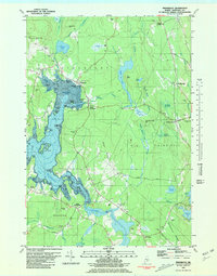
 1981 Blue Hill1981 Print · USGSCoastal Maine's maritime and industrial character is preserved here in the early eighties. Researchers can trace family history through the Early Settlers Cemetery or locate landmarks like Stevens Academy and the old Blue Hill Airport.2 unique versions available
 - 1981 Map of Bartlett Island, 1982 Print
 1981 Bartlett Island1982 Print · USGSMount Desert Island's western coastline and the surrounding islands of Blue Hill Bay are captured here in the early eighties. Local historians can trace family names and early sites at Kelleytown, St Andrew by the Lake Ch, and the Murphy Cem.
 - 1981 Map of Branch Lake, 1982 Print
 1981 Branch Lake1982 Print · USGSHancock County’s lakelands are captured here in the early 1980s, documenting the rural communities of North Ellsworth and West Surry. Researchers can trace the Maine Central rail line, locate small family plots like Gott Cem, and explore the shoreline of Branch Lake.2 unique versions available
 - 1981 Map of Newbury Neck, 1982 Print
 1981 Newbury Neck1982 Print · USGSCoastal Hancock County at the start of the 1980s reveals a landscape of wooded peninsulas and traditional shoreline communities. Genealogists can locate family burial grounds like Whittemore Cem and trace old roads through South Surry and West Trenton.
 - 1982 Map of Orland, 1983 Print
 1982 Orland1983 Print · USGSHancock County’s coastal interior is captured here in the early eighties, showing the transition from riverfront settlements to inland lakes. Researchers can trace ancestral sites at Back Ridge Cem, visit East Orland, or locate the Craig Brook National Fish Hatchery.
 - 1985 Map of Bangor
 1985 Bangor1985 Print · USGSMid-Maine during the mid-eighties centers on the industrial pulse of the Penobscot River and its critical rail connections. Genealogists and historians can trace the development of river towns from Old Town to Ellsworth and locate regional landmarks like Fort Knox State Park.
 - 1985 Map of Bar Harbor
 1985 Bar Harbor1985 Print · USGSCoastal Hancock County in the mid-eighties shows an intricate landscape of island communities and protected wilderness. Trace the boundaries of Acadia National Park or locate seafaring hubs like Stonington and Bar Harbor.2 unique versions available
End of results
Showing maps 1-9 of 9
Top cities near Blue Hill
- Ellsworth historical maps
- Bar Harbor historical maps
- Bucksport historical maps
- Hancock historical maps
- Orland historical maps
- Deer Isle historical maps
See more
Top neighborhoods of Blue Hill
Frequently asked questions
- What are the different types of historical maps available for Blue Hill?
- What is the oldest map of Blue Hill?
- Where can I purchase historical maps of Blue Hill for my home or office?
- Where can I download high-res historical maps of Blue Hill?
- Are there historical topographic maps available for Blue Hill?
- Is there historical aerial imagery available for Blue Hill?
- Where are historical maps of Blue Hill sourced from?