1980s Maps of Bucksport, Maine
Explore 5 historic maps of Bucksport from the 1980s. These maps offer a rare glimpse into what life looked like during the 1980s — showing old roads, neighborhoods, homes, and landmarks that have changed or disappeared over time.
Whether you're researching your family's past, planning a metal detecting trip, or studying how Bucksport's landscape evolved across the 1980s, these high-resolution maps are a powerful tool for exploring the history of this region.
- Focus on a specific era: All maps on this page are from the 1980s, giving you a focused view of this time period.
- See what’s changed: Compare century-old streets, trails, and buildings to today's modern landscape using overlays and satellite layers.
- Research with precision: Use these maps for genealogy, historical research, land use analysis, or educational projects.
- View, download, or print: Maps are fully viewable online in high resolution, and can be downloaded or printed for your own records.
Start exploring Bucksport's history through authentic maps from the 1980s. This is your window into the past.
Bucksport, ME maps
(5)- 1982 Map of Brewer Lake
 1982 Brewer Lake1982 Print · USGSHancock County's landscape of ridges and ponds is captured here in the early eighties as rural life centered around towns like Dedham and East Holden. Genealogists can locate several local burial grounds, including Union Cem and Copeland Hill Cem, and trace the path of the Maine Central railroad.
 - 1982 Map of Hampden
 1982 Hampden1982 Print · USGSThe Penobscot River valley in the early eighties shows a landscape of growing riverside towns and historic upland settlements. Genealogists can locate family landmarks from Dorothea Dix Park to several burying grounds including Riverview Cem and Evergreen Cem.
 - 1982 Map of Bucksport
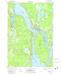 1982 Bucksport1982 Print · USGSThe Penobscot River narrows into a vital maritime corridor at Bucksport in the early eighties. Researchers can trace the layout of Verona Island, the historic batteries of Fort Knox, and family sites at Silver Lake Cem or South Orland.2 unique versions available
 - 1982 Map of Orland, 1983 Print
 1982 Orland1983 Print · USGSHancock County’s coastal interior is captured here in the early eighties, showing the transition from riverfront settlements to inland lakes. Researchers can trace ancestral sites at Back Ridge Cem, visit East Orland, or locate the Craig Brook National Fish Hatchery.
 - 1985 Map of Bangor
 1985 Bangor1985 Print · USGSMid-Maine during the mid-eighties centers on the industrial pulse of the Penobscot River and its critical rail connections. Genealogists and historians can trace the development of river towns from Old Town to Ellsworth and locate regional landmarks like Fort Knox State Park.
End of results
Showing maps 1-5 of 5
Top cities near Bucksport
- Bangor historical maps
- Orono historical maps
- Brewer historical maps
- Ellsworth historical maps
- Hampden historical maps
- Belfast historical maps
See more
Top neighborhoods of Bucksport
- North Bucksport historical maps
- East Bucksport historical maps
- Bucks Mills historical maps
- Bucksport Center historical maps
- Millvale historical maps
Frequently asked questions
- What are the different types of historical maps available for Bucksport?
- What is the oldest map of Bucksport?
- Where can I purchase historical maps of Bucksport for my home or office?
- Where can I download high-res historical maps of Bucksport?
- Are there historical topographic maps available for Bucksport?
- Is there historical aerial imagery available for Bucksport?
- Where are historical maps of Bucksport sourced from?