Old Maps of Bangor, Maine
Explore 40 old maps of Bangor, spanning from 1902 to today. These high-resolution historic maps reveal how streets, neighborhoods, landmarks, and natural features evolved over time — perfect for genealogy, metal detecting, research, and local history exploration.
What you can do with these maps:
- See how Bangor changed over time: Compare historical maps to modern-day views to trace roads, homesites, rail lines & more.
- View detailed metadata: Each map includes creators, publishers, year, scale, and archive source.
- Overlay maps with satellite & LiDAR: Visualize the past alongside modern tools to explore terrain & human change.
- Trusted historical sources: Maps sourced from the USGS, Library of Congress, and other archives.
- Access maps your way: View online, download high-res files, or order prints for personal or research use.
Start exploring old maps of Bangor to uncover forgotten places, hidden landmarks, and the deep history beneath your feet.
Bangor, ME maps
(40)- 1902 Map of Orono
 1902 Orono1902 Print · USGSPenobscot River life at the turn of the century centered on a busy corridor of rail, river, and industry. Researchers can trace the early footprint of the University, the rail lines of the Bangor and Aroostook RR, and settlements like Basin Mills and Indian Island.6 unique versions available
 - 1902 Map of Bangor
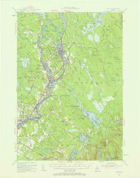
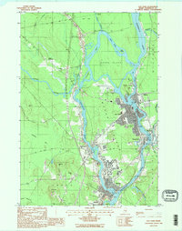
 1902 Bangor1902 Print · USGSThe Penobscot River valley at the turn of the century shows a bustling hub of rail and river commerce connecting Bangor and Brewer. Genealogists and historians can trace old homesteads and transit routes through Kenduskeag, Leather Corner, and along the Maine Central R. R.6 unique versions available
 - 1942 Map of Bangor
 1942 Bangor1942 Print · USGSThe Penobscot River valley thrives in this early-forties survey of the region's industrial and rural heart. Trace the historic street plans of Bangor and Brewer or locate family homesteads near Leather Corner and Snow Corner.
 - 1944 Map of Orono, 1954 Print
 1944 Orono1954 Print · USGSThe Penobscot River corridor is captured here in the mid-1940s, showing the early footprint of the University of Maine and the industrial activity of Old Town. Genealogists and historians can trace family locations through French Settlement, Woodlawn Cem, and the Old Gold Mine.2 unique versions available
 - 1946 Map of Bangor
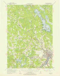
 1946 Bangor1946 Print · USGSBangor and the Penobscot River are captured here in the mid-1940s, showing a critical hub of rail transport and military aviation. Local historians can trace the development of Dow Field, find local schools like Tennyson Sch, or locate family plots in Lakeview Cem.3 unique versions available
 - 1946 Map of Orono
 1946 Orono1946 Print · USGSPenobscot County industry and academia meet along the river in the mid-forties. Genealogists and historians can trace the development of Marsh Island, locate the University of Maine campus, and find local landmarks like the Old Gold Mine Trail.2 unique versions available
 - 1948 Map of Bangor
 1948 Bangor1948 Print · USGSThe Maine coast and its industrial river valleys are captured here shortly after the war, showing the vital shipping and rail hubs of the late 1940s. Genealogists and historians can trace the tracks of the Maine Central RR connecting Bangor, Augusta, and Old Town.
 - 1955 Map of Orono, 1957 Print
 1955 Orono1957 Print · USGSThe Penobscot river valley thrived as a center of education and industry in the mid-fifties, anchored by Indian Island and the university. Genealogists and historians can trace family-named sites from French Settlement to Clewleyville Corners and the Old Gold Mine.4 unique versions available
 - 1955 Map of Bangor, 1957 Print
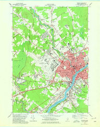
 1955 Bangor1957 Print · USGSBangor and the surrounding Penobscot Valley are captured here in the mid-fifties, showing a landscape defined by riverside industry and lakefront life. Researchers can trace historic rail connections at Northern Maine Junction and locate family landmarks like Lakeside Ldg or Evergreen Cem.3 unique versions available
 - 1956 Map of Bangor, 1966 Print
 1956 Bangor1966 Print · USGSMid-century Maine comes alive in this survey of the rugged coast and river valleys during the 1950s. Genealogists and historians can trace the vital rail corridors of the Maine Central RR connecting timber towns like Old Town to the coast at Bar Harbor.3 unique versions available
 - 1960 Map of Bangor
 1960 Bangor1960 Print · USGSCentral Maine in the sixties reveals a landscape of river-powered industry and sprawling coastal island chains. Researchers can trace the rail corridors of the Maine Central or locate mid-century aviation landmarks like Dow Air Force Base.
 - 1961 Map of Bangor
 1961 Bangor1961 Print · USGSMid-century Maine comes alive through its busy river ports and rocky archipelagoes during a period of steady maritime and rail commerce. Researchers can trace the path of the Maine Central railroad and locate coastal landmarks from Acadia National Park to Vinalhaven Island.
 - 1977 Map of Pushaw Lake
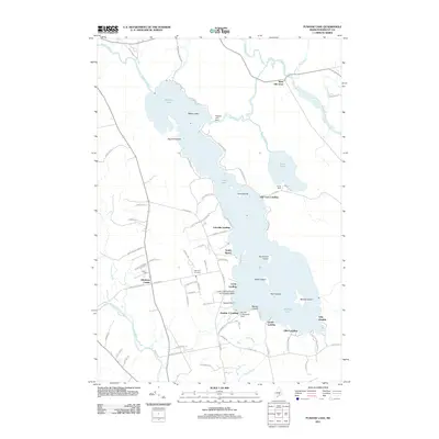
 1977 Pushaw Lake1977 Print · USGSPenobscot County life in the late seventies is centered on the expansive waters of Pushaw Lake and the rural crossroads of Glenburn Center. Genealogists and local historians can trace the Bangor and Aroostook rail line, locate Lakeview Cem, or explore the many landings like Elliot Landing.
 - 1978 Map of Bangor, 1979 Print
 1978 Bangor1979 Print · USGSGreater Bangor at the close of the 1970s shows a classic Maine river city balancing its rail-and-river heritage with modern aviation. Genealogists and historians can locate family plots at Mt Pleasant Cem or trace the early paths of the Maine Central Railroad.2 unique versions available
 - 1985 Map of Bangor
 1985 Bangor1985 Print · USGSMid-Maine during the mid-eighties centers on the industrial pulse of the Penobscot River and its critical rail connections. Genealogists and historians can trace the development of river towns from Old Town to Ellsworth and locate regional landmarks like Fort Knox State Park.
 - 1988 Map of Veazie
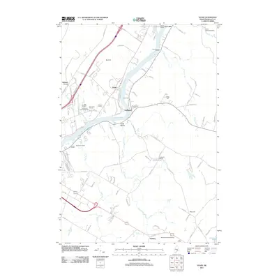
 1988 Veazie1988 Print · USGSPenobscot County settlements and industrial infrastructure are captured here in the late eighties as the riverfront evolved. Researchers can locate vanished landmarks like the Drive-In Theater and the Hydro-Power Dam near Clewleyville Corners.2 unique versions available
 - 1988 Map of Old Town
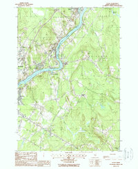
 1988 Old Town1988 Print · USGSThe Penobscot and Stillwater rivers converge here in the 1980s, framing the industrial and academic centers of Old Town and the Univ of Maine. Trace riverfront history across Marsh Island or locate smaller locales like Great Works and Stillwater.2 unique versions available
 - 1994 Map of Bangor
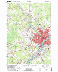
 1994 Bangor1994 Print · USGSThe Penobscot River valley and the coastal highlands of eastern Maine are captured here in the mid-1990s. Researchers can trace the industrial rail corridors of the Maine Central Railroad or explore the landscape around Old Town, Bucksport, and Graham Lake.
 - 1996 Map of Bangor, 2000 Print
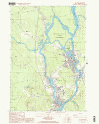
 1996 Bangor2000 Print · USGSBangor and the Penobscot River valley are captured in the mid-nineties, showing a landscape defined by collegiate growth and aviation infrastructure. Researchers can trace the development of Husson College and the Bangor International Airport alongside landmarks like Northern Maine Junction.
 - 1998 Map of Old Town, 2001 Print
 1998 Old Town2001 Print · USGSThe Penobscot River valley near the turn of the millennium shows a landscape defined by its island settlements and university influence. Researchers can trace the layout of the Penobscot Indian Reservation or locate landmarks like Dewitt Field and the Univ of Maine.
 - 2011 Map of Bangor, 2011 Print
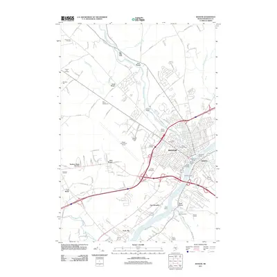 2011 Bangor2011 Print · USGSCovers Bangor, including Orono, Brewer, and other nearby areas
 - 2011 Map of Old Town, 2011 Print
 2011 Old Town2011 Print · USGSCovers Bangor, including Orono, Old Town, and other nearby areas
 - 2011 Map of Veazie, 2011 Print
 2011 Veazie2011 Print · USGSCovers Bangor, including Orono, Brewer, and other nearby areas
 - 2011 Map of Pushaw Lake, 2011 Print
 2011 Pushaw Lake2011 Print · USGSCovers Bangor, including Orono, Old Town, and other nearby areas
 - 2014 Map of Veazie, 2014 Print
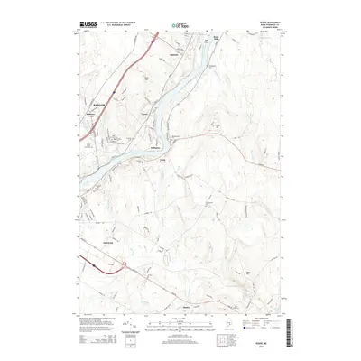 2014 Veazie2014 Print · USGSCovers Bangor, including Orono, Brewer, and other nearby areas
Showing maps 1-25 of 40
Top cities near Bangor
- Orono historical maps
- Brewer historical maps
- Ellsworth historical maps
- Hampden historical maps
- Old Town historical maps
- Hermon historical maps
See more
Top neighborhoods of Bangor
- Pickering Square historical maps
- West Market Square historical maps
- Fairmount historical maps
- Little City historical maps
- Ohio to Hammond historical maps
- Outer Ohio historical maps
See more
Frequently asked questions
- What are the different types of historical maps available for Bangor?
- What is the oldest map of Bangor?
- Where can I purchase historical maps of Bangor for my home or office?
- Where can I download high-res historical maps of Bangor?
- Are there historical topographic maps available for Bangor?
- Is there historical aerial imagery available for Bangor?
- Where are historical maps of Bangor sourced from?