1940s Maps of Gouldsboro, Maine
Explore 6 historic maps of Gouldsboro from the 1940s. These maps offer a rare glimpse into what life looked like during the 1940s — showing old roads, neighborhoods, homes, and landmarks that have changed or disappeared over time.
Whether you're researching your family's past, planning a metal detecting trip, or studying how Gouldsboro's landscape evolved across the 1940s, these high-resolution maps are a powerful tool for exploring the history of this region.
- Focus on a specific era: All maps on this page are from the 1940s, giving you a focused view of this time period.
- See what’s changed: Compare century-old streets, trails, and buildings to today's modern landscape using overlays and satellite layers.
- Research with precision: Use these maps for genealogy, historical research, land use analysis, or educational projects.
- View, download, or print: Maps are fully viewable online in high resolution, and can be downloaded or printed for your own records.
Start exploring Gouldsboro's history through authentic maps from the 1940s. This is your window into the past.
Gouldsboro, ME maps
(6)- 1942 Map of Bar Harbor
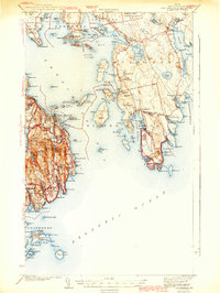 1942 Bar Harbor1942 Print · USGSMount Desert Island and the Schoodic Peninsula are shown just before the war in this detailed coastal survey. Genealogists and historians can trace the foundations of Bar Harbor, locate the village of Islesford, and explore landmarks like Chicken Mill Pond.4 unique versions available
 - 1942 Map of Cherryfield
 1942 Cherryfield1942 Print · USGSCoastal Washington County in the early 1940s reveals a landscape of tidal bays and glacial barrens. Trace family roots and old land patterns in Cherryfield, Millbridge, and Harrington, or locate the scientific U S C & G SURVEY BASE LINE.
 - 1942 Map of Tunk Lake
 1942 Tunk Lake1942 Print · USGSHancock County’s inland peaks and coastal villages are captured here during the early 1940s, just as aerial photography began to modernize regional mapping. Researchers can locate the Tunk Lake Sch, coastal rail stops at Waukeag, and the prominent Fire Tower on Schoodic Mtn.
 - 1948 Map of Bangor
 1948 Bangor1948 Print · USGSThe Maine coast and its industrial river valleys are captured here shortly after the war, showing the vital shipping and rail hubs of the late 1940s. Genealogists and historians can trace the tracks of the Maine Central RR connecting Bangor, Augusta, and Old Town.
 - 1948 Map of Petit Manan, 1970 Print
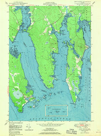 1948 Petit Manan1970 Print · USGSThe coastal village of Corea and the surrounding bays of Washington County are captured here in the years following World War II. Researchers can trace family sites near Corea Cem, identify early coastal landmarks like Eagle Hill, and explore the maritime geography of Steuben Hbr and Dyer Harbor.3 unique versions available
 - 1948 Map of Cherryfield, 1978 Print
 1948 Cherryfield1978 Print · USGSCoastal Washington County is captured here in the mid-twentieth century as the rail and river networks connected inland timber to the sea. Researchers can trace family sites in Cherryfield and Milbridge, or locate small historic settlements like Smithville and Unionville.
End of results
Showing maps 1-6 of 6
Top cities near Gouldsboro
- Bar Harbor historical maps
- Hancock historical maps
- Mount Desert historical maps
- Southwest Harbor historical maps
- Lamoine historical maps
- Franklin historical maps
See more
Top neighborhoods of Gouldsboro
- Prospect Harbor historical maps
- Ashville historical maps
- Birch Harbor historical maps
- Corea historical maps
- South Gouldsboro historical maps
- West Gouldsboro historical maps
Frequently asked questions
- What are the different types of historical maps available for Gouldsboro?
- What is the oldest map of Gouldsboro?
- Where can I purchase historical maps of Gouldsboro for my home or office?
- Where can I download high-res historical maps of Gouldsboro?
- Are there historical topographic maps available for Gouldsboro?
- Is there historical aerial imagery available for Gouldsboro?
- Where are historical maps of Gouldsboro sourced from?