Old Maps of Vinalhaven, Maine
Explore 77 old maps of Vinalhaven, spanning from 1904 to today. These high-resolution historic maps reveal how streets, neighborhoods, landmarks, and natural features evolved over time — perfect for genealogy, metal detecting, research, and local history exploration.
What you can do with these maps:
- See how Vinalhaven changed over time: Compare historical maps to modern-day views to trace roads, homesites, rail lines & more.
- View detailed metadata: Each map includes creators, publishers, year, scale, and archive source.
- Overlay maps with satellite & LiDAR: Visualize the past alongside modern tools to explore terrain & human change.
- Trusted historical sources: Maps sourced from the USGS, Library of Congress, and other archives.
- Access maps your way: View online, download high-res files, or order prints for personal or research use.
Start exploring old maps of Vinalhaven to uncover forgotten places, hidden landmarks, and the deep history beneath your feet.
Vinalhaven, ME maps
(77)- 1904 Map of Deer Isle
 1904 Deer Isle1904 Print · USGSThe Maine coast in the early nineteen-hundreds is defined by its network of island settlements and steamboat paths. Genealogists and historians can trace family locations from Stonington to Isle au Haut, or locate maritime landmarks like Deer I. Thorofare L.H. and The Haulover.4 unique versions available
 - 1904 Map of Vinalhaven
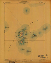
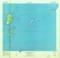
 1904 Vinalhaven1904 Print · USGSThe Fox Islands and Penobscot Bay are captured here at a maritime peak, when steamboats and granite quarries drove the local economy. Researchers can trace historic ferry paths and find family landmarks like Coombs Hill, Browns Head L.H., and the settlement at North Haven.4 unique versions available
 - 1905 Map of Penobscot Bay
 1905 Penobscot Bay1905 Print · USGSThe Maine coastline at the dawn of the twentieth century was a bustling network of maritime trade and summer retreats. Genealogists and historians can trace the foundations of coastal life through the STEAMBOAT ROUTE, the Northport Camp Ground, and settlements like Sargentville.3 unique versions available
 - 1906 Map of Matinicus
 1906 Matinicus1906 Print · USGSCoastal Maine's most remote island communities are captured at the beginning of the twentieth century. Researchers can trace the early footprints of Matinicus and Criehaven, locate the Matinicus Rock LH, and follow the old Steamboat Route.4 unique versions available
 - 1941 Map of Vinalhaven, 1962 Print
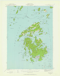 1941 Vinalhaven1962 Print · USGSPenobscot Bay is captured in high detail during the early 1940s, showing the intricate island communities of the Fox Islands. Researchers can trace family sites near Seaview Cem, locate maritime landmarks like Heron Neck L H, and explore the geography of Hurricane Island.3 unique versions available
 - 1942 Map of Deer Isle, 1958 Print
 1942 Deer Isle1958 Print · USGSCoastal Maine life in the 1940s centers on the granite industry and maritime trade routes throughout Deer Isle and the Penobscot Bay islands. Genealogists and historians can trace the foundations of local economies through the QUARRIES at Stonington and the many family-named landmarks like Greenlaw Neck or Conary Head.3 unique versions available
 - 1944 Map of Vinalhaven
 1944 Vinalhaven1944 Print · USGSThe Fox Islands of Maine are captured here during the 1940s, showing the intricate island-and-bay network of Penobscot Bay. Genealogists can trace early family sites like Fuller Cem and Browns Cem or locate maritime landmarks such as Browns Head LH.2 unique versions available
 - 1944 Map of Deer Isle
 1944 Deer Isle1944 Print · USGSPenobscot Bay and the Eggemoggin Reach appear here in the early 1940s, highlighting the granite and maritime hubs of the Maine coast. Genealogists and historians can locate family homes near Stonington, coastal Quarries, and landmarks like Forest Cem.2 unique versions available
 - 1948 Map of Bangor
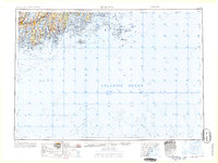
 1948 Bangor1948 Print · USGSThe Maine coast and its industrial river valleys are captured here shortly after the war, showing the vital shipping and rail hubs of the late 1940s. Genealogists and historians can trace the tracks of the Maine Central RR connecting Bangor, Augusta, and Old Town.
 - 1948 Map of Bath
 1948 Bath1948 Print · USGSMid-coast Maine’s intricate shoreline and island outposts are captured here just after the war. Researchers can trace historic maritime settlements from Bath to Friendship and locate remote landmarks like Monhegan Island and Pemaquid Point.2 unique versions available
 - 1953 Map of Matinicus, 1959 Print
 1953 Matinicus1959 Print · USGSThe outer islands of Knox County are captured here in the early 1950s, showing the remote maritime life of the Gulf of Maine. Genealogists and historians can trace the small settlements at Matinicus and Criehaven or locate the distant U S Coast Guard Reservation on Matinicus Rock.4 unique versions available
 - 1956 Map of Bangor, 1966 Print
 1956 Bangor1966 Print · USGSMid-century Maine comes alive in this survey of the rugged coast and river valleys during the 1950s. Genealogists and historians can trace the vital rail corridors of the Maine Central RR connecting timber towns like Old Town to the coast at Bar Harbor.3 unique versions available
 - 1956 Map of Bath, 1974 Print
 1956 Bath1974 Print · USGSCoastal Maine in the mid-fifties reveals a landscape of deep-water harbors and island outposts as the region transitioned from industrial roots to a summer destination. Genealogists can trace maritime families in Boothbay Harbor, Tenants Harbor, and on remote Monhegan Island.
 - 1957 Map of Bath
 1957 Bath1957 Print · USGSThe Maine coast in the mid-fifties is captured here, from the shipbuilding hubs of Bath and Brunswick to the granite reaches of Rockland. Researchers can trace the Maine Central RR line and remote island outposts like Monhegan Island and Matinicus Isle.
 - 1958 Map of Bath
 1958 Bath1958 Print · USGSCoastal Maine in the late fifties reveals a landscape of industrial river towns and remote island outposts. Genealogists and historians can trace the Maine Central RR through Bath, explore the islands of Muscongus Bay, or locate seafaring families at Pemaquid Point.
 - 1960 Map of Bangor
 1960 Bangor1960 Print · USGSCentral Maine in the sixties reveals a landscape of river-powered industry and sprawling coastal island chains. Researchers can trace the rail corridors of the Maine Central or locate mid-century aviation landmarks like Dow Air Force Base.
 - 1961 Map of Bangor
 1961 Bangor1961 Print · USGSMid-century Maine comes alive through its busy river ports and rocky archipelagoes during a period of steady maritime and rail commerce. Researchers can trace the path of the Maine Central railroad and locate coastal landmarks from Acadia National Park to Vinalhaven Island.
 - 1963 Map of Bath
 1963 Bath1963 Print · USGSThe Maine Midcoast in the early sixties remains a world of tidal rivers and jagged peninsulas tied to the sea. Genealogy and local history researchers can trace the rail lines of the Maine Central RR and locate offshore communities like Matinicus Island and Monhegan.2 unique versions available
 - 1965 Map of Bath
 1965 Bath1965 Print · USGSThe Midcoast Maine shoreline and its archipelago come alive in the mid-1960s, showing the region's deep reliance on river and rail. Researchers can trace historic harbor towns like Boothbay Harbor and Damariscotta, and locate coastal landmarks from Pemaquid Point to the Fort Popham Military Res.
 - 1982 Map of Vinalhaven, 1983 Print
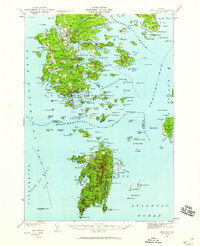
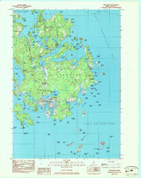 1982 Vinalhaven1983 Print · USGSVinalhaven and the surrounding islands are shown in the early 1980s, highlighting the area’s quarrying heritage and maritime culture. Researchers can trace family history at Hill Cem or locate industrial sites like Lawson Quarry Pond and the coastal Lighthouse.3 unique versions available
 - 1982 Map of Leadbetter Island, 1983 Print
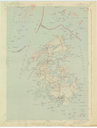
 1982 Leadbetter Island1983 Print · USGSPenobscot Bay islands like Vinalhaven and North Haven are shown in the early eighties as a dense network of granite heights and tidal channels. Researchers can locate coastal landmarks including the Lighthouse at Browns Head, the Outward Bound Sch, and the inland waters of Dyer Pond.
 - 1982 Map of North Haven East, 1983 Print
 1982 North Haven East1983 Print · USGSThe Fox Islands archipelago in the early eighties highlights a seafaring community connected by the Fox Islands Thorofare and the North Haven Ferry. Genealogists can trace family lines through the Seaview Cem or explore the landing at The Wood Landing.
 - 1983 Map of Isle Au Haut West
 1983 Isle Au Haut West1983 Print · USGSThe coastal waters of Knox County in the early 1980s reveal a landscape of secluded island life and maritime heritage. Genealogists and historians can locate family landmarks like Turners Cem or trace the coastline past the Robinson Point Lighthouse and Saddleback Ledge Lighthouse.
 - 1983 Map of North Haven West
 1983 North Haven West1983 Print · USGSMid-coast Maine’s maritime landscape is captured here in the early eighties, showing the intricate shorelines of Penobscot Bay. Genealogists and historians can trace coastal homesteads near Fuller Cem, landholdings on Seven Hundred Acre Island, and old routes like Main Road.
 - 1985 Map of Matinicus
 1985 Matinicus1985 Print · USGSThe outer islands of Knox County are captured in the mid-1980s, highlighting the isolated settlements of the Gulf of Maine. Genealogists and maritime historians can locate homes and landmarks in Matinicus and Criehaven, or trace the shores of Ragged Island and Seal Island.
Showing maps 1-25 of 77
Top cities near Vinalhaven
- Camden historical maps
- Rockport historical maps
- Deer Isle historical maps
- Owls Head historical maps
- Stonington historical maps
- Brooklin historical maps
See more
Frequently asked questions
- What are the different types of historical maps available for Vinalhaven?
- What is the oldest map of Vinalhaven?
- Where can I purchase historical maps of Vinalhaven for my home or office?
- Where can I download high-res historical maps of Vinalhaven?
- Are there historical topographic maps available for Vinalhaven?
- Is there historical aerial imagery available for Vinalhaven?
- Where are historical maps of Vinalhaven sourced from?