
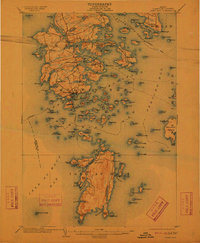
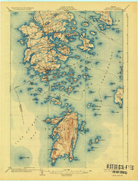
1904 Map of Deer Isle
USGS Topo · Published 1904About this map
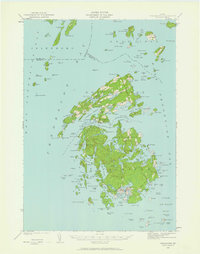
Stonington serves as the bustling maritime hub for this coastal area at the dawn of the twentieth century, anchored by its harbor and nearby Crotch I. and Sand I. within Merchant Row. The map captures a detailed geography of island life, from the scattered hamlets of Sunset, South Deer Isle, and Mountainville to the isolated community of Isle au Haut across the Isle au Haut Bay. Insight into the era's transport is found in the established Steamboat Route that navigated through Eggemoggin Reach, connecting the mainland to maritime outposts like Sunshine and Naskeag Harbor. Local navigation was further aided by landmarks such as the Deer I. Thorofare L.H.. The intricate network of coves, including Crockett Cove and Southeast Harbor, highlights the reliance on water-based travel and industry in this Maine archipelago.
Find a feature on this map
175 named features on this map. Tap any name to fly to it.
Don’t see what you’re looking for? This feature index may not catch every label — zoom into the map to look around manually.
Map Details
Editions of this 1904 Deer Isle Map
4 editions found

Other maps of this area

1902 · Castine
USGS Topo · 1:62,500

1904 · Castine
USGS Topo · 1:62,500

1904 · Mount Desert
USGS Topo · 1:62,500

1904 · Swan Island
USGS Topo · 1:62,500

1904 · Bluehill
USGS Topo · 1:62,500

1904 · Vinalhaven
USGS Topo · 1:62,500

1905 · Penobscot Bay
USGS Topo · 1:125,000
1906 · Matinicus
USGS Topo · 1:62,500
1941 · Castine
USGS Topo · 1:62,500
1941 · Vinalhaven
USGS Topo · 1:62,500