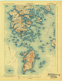
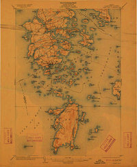
1904 Map of Deer Isle
USGS Topo · Published 1926About this map
Stonington serves as the bustling maritime hub at the southern tip of the island in this early 20th-century survey, surrounded by a complex network of coastal villages like Sunset and Mountainville. The coastal economy of Hancock County is illustrated by the established Steamboat Route winding through Merchant Row and Eggemoggin Reach, connecting the archipelago to mainland trade. The interior of the islands is dotted with freshwater bodies such as Lily Pond and Torrey Pond, while the shoreline is defined by numerous family-named coves including Greenlaw Cove and Conary Cove. To the south, the isolated elevations of Isle au Haut rise prominently, featuring landmarks like Bald Mt. and the sheltered Moore Harbor. This topographical record documents the transition of these island communities from traditional fishing and granite quarrying centers into more connected coastal settlements.
Find a feature on this map
147 named features on this map. Tap any name to fly to it.
Don’t see what you’re looking for? This feature index may not catch every label — zoom into the map to look around manually.
Map Details
Editions of this 1904 Deer Isle Map
4 editions found

Other maps of this area

1902 · Castine
USGS Topo · 1:62,500

1904 · Deer Isle
USGS Topo · 1:62,500

1904 · Castine
USGS Topo · 1:62,500

1904 · Mount Desert
USGS Topo · 1:62,500

1904 · Swan Island
USGS Topo · 1:62,500

1904 · Bluehill
USGS Topo · 1:62,500

1904 · Vinalhaven
USGS Topo · 1:62,500

1905 · Penobscot Bay
USGS Topo · 1:125,000
1906 · Matinicus
USGS Topo · 1:62,500
1941 · Castine
USGS Topo · 1:62,500