Old Maps of Bowmantown Township, Maine for Metal Detecting
Plan your next treasure hunt with 25 historic maps of Bowmantown Township. Find old homesites, ghost towns, trails, and gathering spots that may be lost to time — perfect for identifying promising metal detecting locations.
- Locate forgotten sites: Uncover places like long-lost settlements, abandoned rail lines, or gathering spots.
- Plan better hunts: Use map overlays combined with LiDAR or satellite views to narrow in on historically rich areas.
- Made for detectorists: Thousands of hobbyists use these maps to discover relics, coins, and hidden history.
Use these historic maps to boost your research and find new opportunities beneath the surface of Bowmantown Township.
Bowmantown Township, ME maps
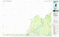
(25)- 1927 Map of Moose Bog
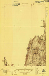 1927 Moose Bog1927 Print · USGSThe wilderness of the North Woods is charted in the late twenties along the border where Maine, New Hampshire, and Quebec meet. Researchers can trace the remote Bowman Farm and the high-elevation wetlands of Moose Bog and the Third East Branch Magalloway River.3 unique versions available
 - 1931 Map of Moose Bog
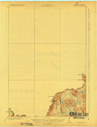 1931 Moose Bog1931 Print · USGSThe Maine and New Hampshire borderlands are captured here in the early thirties, showing a remote wilderness of high peaks and river headwaters. Genealogists and historians can trace family-named landmarks like Bowman Farm, Bowman Hill, and the secluded waters of Moose Bog.5 unique versions available
 - 1932 Map of Arnold Pond
 1932 Arnold Pond1932 Print · USGSThe Maine-Quebec borderlands come into focus in the early 1930s, showing a remote landscape of mountain ponds and international crossings. Trace the old route of State Highway No 143 past the U S Customs station near Arnold Pond and Crosby Pond.3 unique versions available
 - 1935 Map of Arnold Pond
 1935 Arnold Pond1935 Print · USGSThe international border between Maine and Quebec is captured here in the mid-1930s, showing the remote township lines and high mountain peaks. You can trace the path of Route 4 past U.S. Customs and explore the alpine waters of Arnold Pond and Big Island Pond.3 unique versions available
 - 1949 Map of Jackman
 1949 Jackman1949 Print · USGSThe Quebec and Maine borderlands are shown in great detail during the late 1940s, highlighting the industrial and natural geography of the region. Trace old rail lines like the Canadian Pacific and locate settlements from Sherbrooke to Scotstown.2 unique versions available
 - 1963 Map of Jackman
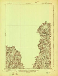
 1963 Jackman1963 Print · USGSThe international borderlands of Maine and Quebec come alive in the mid-twentieth century, showing a landscape of timber towns and rail connections. Genealogists and historians can trace the paths of the Canadian Pacific Railway through Jackman or locate families in Sherbrooke and Megantic.
 - 1966 Map of Sherbrooke
 1966 Sherbrooke1966 Print · USGSThe borderlands of Quebec and Maine come alive in the mid-1960s, documenting the industrial towns and deep woods of the Northeast. Genealogists can trace family lines through Sherbrooke and Coaticook, or locate remote logging outposts along the Moose River and Flagstaff Lake.
 - 1976 Map of Sherbrooke
 1976 Sherbrooke1976 Print · USGSThe northern Maine woods and Quebec’s Eastern Townships meet in this mid-century survey of the rugged international borderlands. Genealogists and historians can trace rail-and-river connections through Thetford Mines, follow the Dead River to Flagstaff Lake, or locate small border crossings at Stanhope and Beecher Falls.2 unique versions available
 - 1976 Map of Moose Bog, 1983 Print
 1976 Moose Bog1983 Print · USGSThe northern Maine wilderness near the Quebec border is seen here in the mid-1970s through detailed aerial orthophotography. Trace the remote waterways of the Magalloway River and identify secluded landmarks like Moose Bog and Barker Pond.
 - 1977 Map of Twin Peaks, 1983 Print
 1977 Twin Peaks1983 Print · USGSThe international borderlands of Maine and Quebec come into sharp focus in the late 1970s through this aerial orthophoto. Researchers can trace the rugged drainage of the East Branch Magalloway River and the forested slopes of Mont Gosford.
 - 1986 Map of Flagstaff Lake
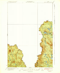
 1986 Flagstaff Lake1986 Print · USGSThe Maine North Woods and the Dead River valley are captured here in the mid-1980s, an era of established hydroelectric lakes and outdoor recreation. Genealogists and researchers can trace the vicinity of Kennebago Settlement, Langtown Mill, and the villages of Stratton and Eustis.
 - 1986 Map of Sherbrooke
 1986 Sherbrooke1986 Print · USGSThe Great North Woods of the mid-eighties appear in detail across this survey of the New Hampshire and Canadian borderlands. Researchers can trace the entire chain of the First Connecticut Lake through the fourth, alongside remote settlements like Pittsburg and Beecher Falls.2 unique versions available
 - 1989 Map of Moose Bog
 1989 Moose Bog1989 Print · USGSThe northern reaches of the Maine-Quebec border come into focus in the late 1980s, showing a landscape of high peaks and river headwaters. Trace the historic Bowman Farm (Site) or locate remote landmarks like Mount D'Urban and the Magalloway River.
 - 1990 Map of Twin Peaks
 1990 Twin Peaks1990 Print · USGSThe Maine-Quebec borderlands in the early 1990s reveal a landscape of deep timber and remote watersheds within Oxford County. Researchers can trace the rugged drainage of the Magalloway River and locate isolated features like Twin Peaks, Abbie Pond, and scattered Gravel Pits.
 - 1994 Map of Flagstaff Lake
 1994 Flagstaff Lake1994 Print · USGSThe Maine wilderness and the Quebec border come alive in this mid-nineties survey of the Dead River country. Researchers can trace the Appalachian Trail over Bigelow Mountain and locate remote sites like Kennebago Settlement.
 - 2011 Map of Moose Bog, 2011 Print
 2011 Moose Bog2011 Print · USGSCovers Bowmantown Township, including Pittsburg, Notre-Dame-des-Bois, and other nearby areas
 - 2011 Map of Twin Peaks, 2011 Print
 2011 Twin Peaks2011 Print · USGSCovers Bowmantown Township, including Saint-Augustin-de-Woburn, Notre-Dame-des-Bois, and other nearby areas
 - 2014 Map of Twin Peaks, 2014 Print
 2014 Twin Peaks2014 Print · USGSCovers Bowmantown Township, including Saint-Augustin-de-Woburn, Notre-Dame-des-Bois, and other nearby areas
 - 2014 Map of Moose Bog, 2014 Print
 2014 Moose Bog2014 Print · USGSCovers Bowmantown Township, including Pittsburg, Notre-Dame-des-Bois, and other nearby areas
 - 2018 Map of Twin Peaks, 2018 Print
 2018 Twin Peaks2018 Print · USGSCovers Bowmantown Township, including Saint-Augustin-de-Woburn, Notre-Dame-des-Bois, and other nearby areas
 - 2018 Map of Moose Bog, 2018 Print
 2018 Moose Bog2018 Print · USGSCovers Bowmantown Township, including Pittsburg, Notre-Dame-des-Bois, and other nearby areas
 - 2021 Map of Twin Peaks, 2021 Print
 2021 Twin Peaks2021 Print · USGSCovers Bowmantown Township, including Saint-Augustin-de-Woburn, Notre-Dame-des-Bois, and other nearby areas
 - 2021 Map of Moose Bog, 2021 Print
 2021 Moose Bog2021 Print · USGSCovers Bowmantown Township, including Pittsburg, Notre-Dame-des-Bois, and other nearby areas
 - 2024 Map of Twin Peaks, 2024 Print
 2024 Twin Peaks2024 Print · USGSThe international borderlands of Oxford County are captured here in the early twenty-first century, showing a landscape defined by high summits and remote headwaters. Researchers can trace the drainage of Twin Peaks into Upper Black Pond or follow the route of Deer Pond Rd near the Canadian line.
 - 2024 Map of Moose Bog, 2024 Print
 2024 Moose Bog2024 Print · USGSThe international border and the Maine-New Hampshire state line meet in this remote northern timberland during the early twenty-first century. Researchers can trace historic access routes like Magalloway Rd and map the drainages of Boundary Pond and the West Branch Magalloway River.
End of results
Showing maps 1-25 of 25
Top cities near Bowmantown Township
Frequently asked questions
- What are the different types of historical maps available for Bowmantown Township?
- What is the oldest map of Bowmantown Township?
- Where can I purchase historical maps of Bowmantown Township for my home or office?
- Where can I download high-res historical maps of Bowmantown Township?
- Are there historical topographic maps available for Bowmantown Township?
- Is there historical aerial imagery available for Bowmantown Township?
- Where are historical maps of Bowmantown Township sourced from?