Old Maps of Oxford County, Maine
Explore 512 old maps of Oxford County, spanning from 1893 to today. These high-resolution historic maps reveal how streets, neighborhoods, landmarks, and natural features evolved over time — perfect for genealogy, metal detecting, research, and local history exploration.
What you can do with these maps:
- See how Oxford County changed over time: Compare historical maps to modern-day views to trace roads, homesites, rail lines & more.
- View detailed metadata: Each map includes creators, publishers, year, scale, and archive source.
- Overlay maps with satellite & LiDAR: Visualize the past alongside modern tools to explore terrain & human change.
- Trusted historical sources: Maps sourced from the USGS, Library of Congress, and other archives.
- Access maps your way: View online, download high-res files, or order prints for personal or research use.
Start exploring old maps of Oxford County to uncover forgotten places, hidden landmarks, and the deep history beneath your feet.
Oxford County, ME maps
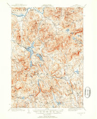
(512)- 1893 Map of Gorham
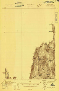
 1893 Gorham1893 Print · USGSThe northern White Mountains at the height of the 1890s show a landscape shaped by early tourism and the timber industry. Genealogists and hikers can trace historic routes like Madison Path and locate vanished landmarks such as Glen House or the rail yards at Berlin Fall.8 unique versions available
 - 1894 Map of North Conway
 1894 North Conway1894 Print · USGSThe Saco River valley and the eastern White Mountains were at a pivotal moment in the 1890s as rail travel and local industry expanded. Genealogists and hikers can trace old routes near North Conway, the granite works at Redstone, and landmarks like Cathedral Ledge.
 - 1896 Map of Norway
 1896 Norway1896 Print · USGSOxford County in the late nineteenth century was a land of timber and steam, where the Grand Trunk met busy lakeside landings. Trace old transport routes between Norway, the mills at Bolsters Mills, and the Steamer Landing on Long Lake.8 unique versions available
 - 1896 Map of Sebago
 1896 Sebago1896 Print · USGSCumberland County’s lake country thrived on a network of water and rail transport at the end of the Victorian era. Researchers can trace the Steamboat Route through Sebago Lake and locate old industrial sites like Songo Lock, Cooks Mills, and Steep Falls.8 unique versions available
 - 1896 Map of North Conway
 1896 North Conway1896 Print · USGSCarroll County and the surrounding New Hampshire-Maine borderlands are captured here during the peak of the Victorian mountain tourism and rail era. Researchers can trace the dual rail lines serving North Conway and locate long-standing settlements like Jackson, Redstone, and Lower Bartlett.9 unique versions available
 - 1896 Map of Gorham
 1896 Gorham1896 Print · USGSThe White Mountains were a bustling hub of rail activity and early tourism in the 1890s as industry met the wilderness. Genealogists and hikers can trace the original routes of the Grand Trunk Railroad, find the historic Glen House, and locate landmarks like Berlin Falls.
 - 1908 Map of Poland
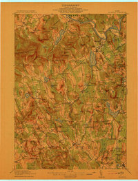
 1908 Poland1908 Print · USGSAndroscoggin County was a thriving hub of rail transport and lakeside resorts in the early nineteen-hundreds. Here you can trace the historic Grand Trunk Railway corridor through Mechanic Falls and locate the famous Poland Spring resort grounds.5 unique versions available
 - 1909 Map of Fryeburg, 1960 Print
 1909 Fryeburg1960 Print · USGSOxford County and the borderlands of Maine and New Hampshire were defined by the shifting waters of the Saco and the Kezar at the century's turn. Genealogists can trace family homesteads near the Battle Monument or locate rural schoolhouses like Foxboro School and Menotomy School.3 unique versions available
 - 1910 Map of Kezar Falls
 1910 Kezar Falls1910 Print · USGSMaine and New Hampshire borderlands are captured here at the height of the railroad era, as the Maine Central linked river towns. Genealogists can trace family footprints through sites like the Parsonsfield Seminary, Merrill Corner, and the Haley School.5 unique versions available
 - 1910 Map of Livermore, 1959 Print
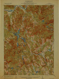
 1910 Livermore1959 Print · USGSMaine's river valleys and lake districts are captured here in the early twentieth century, showing a network of rail-reliant mill towns and rural crossroads. Genealogists can locate family landmarks like Howes Corner and Brettuns Mills, or trace local schools like Saunders School.
 - 1911 Map of Fryeburg
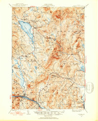
 1911 Fryeburg1911 Print · USGSOxford County at the start of the century shows a landscape of lake-fed valleys and the bustling rail corridor of the Maine Central RR. Genealogists and historians can trace old school districts like Foxboro School, local landmarks like the Battle Monument, and early settlements at Slab City and Lynchville.6 unique versions available
 - 1911 Map of Kezar Falls
 1911 Kezar Falls1911 Print · USGSThe Saco River valley at the turn of the century shows a landscape defined by riverside industry and mountain schools. Genealogists and historians can trace rail depots like Bridgton Junction and early landmarks such as Parsonsfield Seminary and Rankins Mill.5 unique versions available
 - 1911 Map of Bryant Pond, 1953 Print
 1911 Bryant Pond1953 Print · USGSOxford County at the start of the twentieth century shows a landscape of mountain ridges and valley mill towns. You can trace the rural school system and early transport lines through Bryant Pond, West Paris, and the waters of Mt Zircon Spring.3 unique versions available
 - 1911 Map of Buckfield, 1958 Print
 1911 Buckfield1958 Print · USGSOxford County at the dawn of the twentieth century was a landscape of high ridges and tight river valleys connected by new rail lines. Genealogists can locate dozens of district schoolhouses like Bonney School and rural hubs such as Buckfield and Brettuns Mills Livermore P O.
 - 1912 Map of Livermore
 1912 Livermore1912 Print · USGSMaine's lake district comes to life in this pre-war survey of the Androscoggin River valley. Genealogists and historians can trace old homesteads and landmarks like Brettuns Mills Livermore P O, Strickland Ferry, and Monmouth Academy.5 unique versions available
 - 1913 Map of Buckfield
 1913 Buckfield1913 Print · USGSOxford County towns and mountain peaks are captured here in the early twentieth century. Researchers can trace rural family roots through numerous named schoolhouses like the Meadowview Academy, Jones School, and the Bear Mountain School.5 unique versions available
 - 1914 Map of Bethel
 1914 Bethel1914 Print · USGSOxford County mountain life and river valley commerce converge in this pre-World War I survey of the Bethel region. Genealogists and historians can trace old homestead paths to the Town House, several rural schoolhouses like Dresser School, and the path of the Grand Trunk R R.5 unique versions available
 - 1914 Map of Bryant Pond
 1914 Bryant Pond1914 Print · USGSOxford County at the dawn of the Great War was a land of valley mills and mountain schools connected by the iron rail. Genealogists can trace family footprints near Paris Hill, or locate long-standing landmarks like Abbotts Mill and the Patch Mountain School.4 unique versions available
 - 1924 Map of Farmington
 1924 Farmington1924 Print · USGSFranklin County in the early 1920s is a landscape of river-powered mills and intersecting rail lines, including the Sandy River and Rangeley Lakes RR. Genealogists can locate dozens of country schools and rural settlements like Allens Mills and Knowltons Corner.6 unique versions available
 - 1926 Map of Dixfield, 1953 Print
 1926 Dixfield1953 Print · USGSWestern Maine's river valleys and highlands are captured here in the mid-twenties, showcasing the region's rail and timber economy. Genealogists can trace family schoolhouses like Maple Grove Sch or locate old mill sites such as Hildreths Mill near Lake Webb.2 unique versions available
 - 1927 Map of Moose Bog
 1927 Moose Bog1927 Print · USGSThe wilderness of the North Woods is charted in the late twenties along the border where Maine, New Hampshire, and Quebec meet. Researchers can trace the remote Bowman Farm and the high-elevation wetlands of Moose Bog and the Third East Branch Magalloway River.3 unique versions available
 - 1927 Map of Rumford
 1927 Rumford1927 Print · USGSOxford County at the end of the twenties shows a landscape of river-valley industry and upland homesteads. Genealogists can trace family school districts like Red Hill Sch and North Rumford Sch or find the Stockbridge Cem near the Garland settlement.3 unique versions available
 - 1927 Map of Second Lake, 1955 Print
 1927 Second Lake1955 Print · USGSNorthern New Hampshire's high timberlands and the Connecticut River headwaters appear in the late twenties, spanning from the Canadian border down to the academy grants. Researchers can locate remote logging outposts like Depot Camp and Camp No 32 or trace the early shorelines of Second Lake and First Connecticut Lake.6 unique versions available
 - 1929 Map of Dixfield
 1929 Dixfield1929 Print · USGSFranklin and Oxford Counties are captured here in the late twenties, showing the transition from mountain peaks to river valley commerce. Genealogists and historians can trace district schools and old farmstead locations from Weld Corner Sch. down to the Maine Central rail lines at Dixfield.5 unique versions available
 - 1930 Map of Rumford
 1930 Rumford1930 Print · USGSRumford and the Androscoggin River valley are shown here just before the Great Depression, highlighting a bustling landscape of rail and industry. Genealogists and historians can trace local families through many district schools like Woodrow Sch and landmarks like Stockbridge Cem or Rumford Falls.5 unique versions available
Showing maps 1-25 of 512
Top cities of Oxford County
- Paris historical maps
- Norway historical maps
- Rumford historical maps
- Oxford historical maps
- Fryeburg historical maps
- Mexico historical maps
See more
Frequently asked questions
- What are the different types of historical maps available for Oxford County?
- What is the oldest map of Oxford County?
- Where can I purchase historical maps of Oxford County for my home or office?
- Where can I download high-res historical maps of Oxford County?
- Are there historical topographic maps available for Oxford County?
- Is there historical aerial imagery available for Oxford County?
- Where are historical maps of Oxford County sourced from?