1980s Maps of Oxford County, Maine
Explore 35 historic maps of Oxford County from the 1980s. These maps offer a rare glimpse into what life looked like during the 1980s — showing old roads, neighborhoods, homes, and landmarks that have changed or disappeared over time.
Whether you're researching your family's past, planning a metal detecting trip, or studying how Oxford County's landscape evolved across the 1980s, these high-resolution maps are a powerful tool for exploring the history of this region.
- Focus on a specific era: All maps on this page are from the 1980s, giving you a focused view of this time period.
- See what’s changed: Compare century-old streets, trails, and buildings to today's modern landscape using overlays and satellite layers.
- Research with precision: Use these maps for genealogy, historical research, land use analysis, or educational projects.
- View, download, or print: Maps are fully viewable online in high resolution, and can be downloaded or printed for your own records.
Start exploring Oxford County's history through authentic maps from the 1980s. This is your window into the past.
Oxford County, ME maps
(35)- 1980 Map of Oxford, 1981 Print
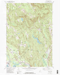 1980 Oxford1981 Print · USGSOxford and Hebron come alive in the 1970s, showcasing a landscape of upland academy life, family farms, and river industry. Genealogists and historians can trace Hebron Academy, the Canadian National rail line, and family landmarks like Sam Rowe Hill Cem.2 unique versions available
 - 1981 Map of Mechanic Falls
 1981 Mechanic Falls1981 Print · USGSAndroscoggin County comes to life in the early 1980s as a region of mills, rails, and recreational waters. Genealogists and local historians can trace the foundations of Mechanic Falls or locate the White Oak Hill Ch and Tenney Cem near the shores of Tripp Pond.
 - 1981 Map of Lake Auburn West
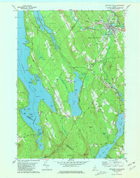
 1981 Lake Auburn West1981 Print · USGSAndroscoggin County was a landscape of small hills and lakeside settlements in the early 1980s. You can trace the path of the Old Railroad Grade or locate local burial sites such as North Auburn Cem and Brookvale Cem.2 unique versions available
 - 1983 Map of Norway
 1983 Norway1983 Print · USGSThe twin villages of Norway and South Paris are captured in the early 1980s, showcasing the area's transition from its industrial roots to a lakeside community. Researchers can trace the Canadian National rail line and locate genealogical sites like Pine Grove Cem and Otisfield Gore.
 - 1983 Map of Waterford Flat, 1984 Print
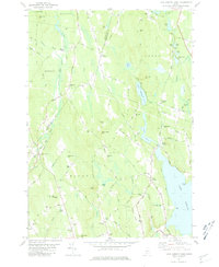
 1983 Waterford Flat1984 Print · USGSOxford County in the early eighties preserves a landscape of quiet village centers and deep-woods summer camps. Genealogists can trace family lines at Bisbee Town Cem and Pim Vale Cem, or locate historic hubs like Waterford Flat and Sodom.
 - 1983 Map of Casco, 1984 Print
 1983 Casco1984 Print · USGSCumberland County’s lakes and ridges are captured here in the early 1980s, showcasing the rural character of Otisfield and Casco. Genealogists and local historians can locate early landmarks like Bell Hill Meeting House, Scribners Mill, and the Otisfield Central School.
 - 1983 Map of North Sebago, 1984 Print
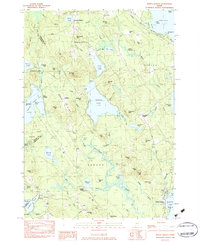 1983 North Sebago1984 Print · USGSThe Sebago and Bridgton area in the early eighties shows a rural landscape of inland lakes and high ridges before modern expansion. Researchers can find dozens of family burial sites like Haley Cem and trace old routes through Sebago Center and Convene.3 unique versions available
 - 1983 Map of Bridgton, 1984 Print
 1983 Bridgton1984 Print · USGSThe Maine lakes region in the early eighties is captured here, centered on the village of Bridgton between Long Lake and Highland Lake. Genealogists can trace family lines through several burial grounds like Ridge Cem and Trafton Cem or locate the old Maple Ridge Sch.
 - 1984 Map of Metallak Mtn, 1985 Print
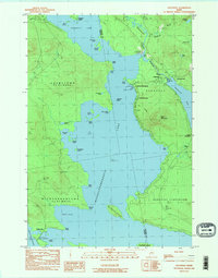
 1984 Metallak Mtn1985 Print · USGSOxford County's high wilderness is captured here in the mid-1980s, showcasing the intersection of timber lands and glacial lakes. Hikers and historians can trace the Appalachian Trail across Elephant Mountain or locate the shoreline settlements of South Arm and Mosquito.2 unique versions available
 - 1984 Map of Puzzle Mountain, 1985 Print
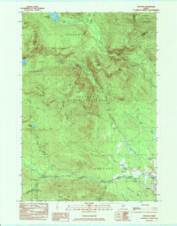
 1984 Puzzle Mountain1985 Print · USGSNorth Newry and the surrounding Oxford County peaks were mapped in the mid-1980s when the region remained a wilderness of high ridgelines and valley streams. Genealogists and hikers can trace the Powers Cem near the Bear River or locate remote landmarks like Lightning Ledge and Jims Pond.
 - 1984 Map of Houghton, 1985 Print
 1984 Houghton1985 Print · USGSThe high peaks and timberlands of Franklin and Oxford counties are captured here in the early eighties. Genealogists and hikers can trace the Old Railroad Grade through the mountains, locate the remote Bemis settlement, or find Angel Falls.
 - 1984 Map of Middle Dam, 1985 Print
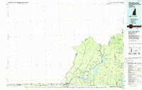
 1984 Middle Dam1985 Print · USGSThe Maine North Woods in the mid-eighties remained a landscape of timber tracts and interconnected waterways. Researchers can trace the drainage from Upper Lake Richardson through The Narrows to the remote settlement at Middle Dam.
 - 1984 Map of Jackson Mountain, 1985 Print
 1984 Jackson Mountain1985 Print · USGSFranklin County's high country is captured here in the mid-1980s, where the Appalachian Trail traverses a landscape of remote peaks and ponds. Trace the local topography from Smalls Falls to the high waters of Jackson Pond and Tumbledown Pond.
 - 1984 Map of Richardson Pond, 1985 Print
 1984 Richardson Pond1985 Print · USGSOxford County’s rugged timberlands and interior lakes are shown in detail during the early eighties. Researchers can trace the shoreline of Aziscohos Lake from Aziscohos Dam to the islands of Upper Richardson Lake.
 - 1984 Map of Old Speck Mountain, 1985 Print
 1984 Old Speck Mountain1985 Print · USGSOxford County’s high peaks and remote notches are captured in the mid-eighties just as the recreational landscape was maturing. Hikers and historians can trace the Appalachian Trail over Old Speck Mtn or find the settlement of Ketchum along the Sunday River.
 - 1984 Map of B Pond, 1985 Print
 1984 B Pond1985 Print · USGSOxford County was a landscape of timber townships and high ridgelines in the mid-eighties. Hikers and historians can trace the Appalachian National Scenic Trail past Dunn Notch or locate the remote Cem near the Ellis River.
 - 1984 Map of Oquossoc, 1985 Print
 1984 Oquossoc1985 Print · USGSMaine's western lakes region comes into focus during the mid-1980s, centered on the historic sporting and rail hub of Oquossoc. Genealogists and local historians can trace the shorelines of Cupsuptic Lake to find named camps and landmarks like Upper Dam and Pleasant Island.2 unique versions available
 - 1984 Map of Andover, 1985 Print
 1984 Andover1985 Print · USGSOxford County mountain terrain and the upper reaches of the Ellis River are documented here in the early 1980s. Hikers and local historians can trace the Appalachian Trail past The Cataracts or locate remote landmarks like C Pond and the Hall Mtn Lean-to.2 unique versions available
 - 1985 Map of Portland, 1986 Print
 1985 Portland1986 Print · USGSThe Maine coast and Sebago Lake region are captured in the mid-1980s, showcasing the transition from traditional maritime centers to a modern transportation hub. Genealogists and historians can trace rail lines like the Grand Trunk RR and find local landmarks such as the U.S. Marine Hospital or Old Orchard Beach.2 unique versions available
 - 1986 Map of Flagstaff Lake
 1986 Flagstaff Lake1986 Print · USGSThe Maine North Woods and the Dead River valley are captured here in the mid-1980s, an era of established hydroelectric lakes and outdoor recreation. Genealogists and researchers can trace the vicinity of Kennebago Settlement, Langtown Mill, and the villages of Stratton and Eustis.
 - 1986 Map of Lewiston
 1986 Lewiston1986 Print · USGSMaine’s industrial river valleys and western mountain foothills are captured here in the mid-eighties as rail and road networks tied the region together. Genealogists and historians can trace the development of mill towns and lakefront settlements from Lisbon to Bethel, following the Androscoggin River and the path of the Maine Central Railroad.2 unique versions available
 - 1986 Map of Rumford
 1986 Rumford1986 Print · USGSWestern Maine in the mid-eighties shows a rugged landscape of industrial river towns and high-country timber plantations. Trace the rail-and-river economy through Rumford, Dixfield, and the Maine Central RR or locate the historic campus of Farmington State College.
 - 1986 Map of Mount Washington
 1986 Mount Washington1986 Print · USGSThe northern New England highlands are shown here in the mid-eighties, centered on the high peaks and river valleys of the New Hampshire borderlands. Researchers can trace historic transportation lines like the Mount Washington Cog Railway and the Maine Central Railroad near Gorham and Lancaster.
 - 1986 Map of Groveton
 1986 Groveton1986 Print · USGSThe North Country's rugged borderlands come into focus in the mid-1980s, tracing the river-and-rail corridors of the Connecticut River valley. Genealogists and historians can locate family landmarks in North Stratford, Groveton, and Guildhall or trace the Canadian National RR.2 unique versions available
 - 1986 Map of Sherbrooke
 1986 Sherbrooke1986 Print · USGSThe Great North Woods of the mid-eighties appear in detail across this survey of the New Hampshire and Canadian borderlands. Researchers can trace the entire chain of the First Connecticut Lake through the fourth, alongside remote settlements like Pittsburg and Beecher Falls.2 unique versions available
Showing maps 1-25 of 35
Top cities of Oxford County
- Paris historical maps
- Norway historical maps
- Rumford historical maps
- Oxford historical maps
- Fryeburg historical maps
- Mexico historical maps
See more
Frequently asked questions
- What are the different types of historical maps available for Oxford County?
- What is the oldest map of Oxford County?
- Where can I purchase historical maps of Oxford County for my home or office?
- Where can I download high-res historical maps of Oxford County?
- Are there historical topographic maps available for Oxford County?
- Is there historical aerial imagery available for Oxford County?
- Where are historical maps of Oxford County sourced from?