1990s Maps of Oxford County, Maine
Explore 27 historic maps of Oxford County from the 1990s. These maps offer a rare glimpse into what life looked like during the 1990s — showing old roads, neighborhoods, homes, and landmarks that have changed or disappeared over time.
Whether you're researching your family's past, planning a metal detecting trip, or studying how Oxford County's landscape evolved across the 1990s, these high-resolution maps are a powerful tool for exploring the history of this region.
- Focus on a specific era: All maps on this page are from the 1990s, giving you a focused view of this time period.
- See what’s changed: Compare century-old streets, trails, and buildings to today's modern landscape using overlays and satellite layers.
- Research with precision: Use these maps for genealogy, historical research, land use analysis, or educational projects.
- View, download, or print: Maps are fully viewable online in high resolution, and can be downloaded or printed for your own records.
Start exploring Oxford County's history through authentic maps from the 1990s. This is your window into the past.
Oxford County, ME maps
(27)- 1990 Map of Lincoln Pond
 1990 Lincoln Pond1990 Print · USGSThe North Woods of Oxford County are captured here in the late twentieth century, showing the wild river systems and timber lands before modern shifts. Researchers can trace remote sites like Bosebuck Camp, the falls at Big Falls, and the shoreline of Aziscohos Lake.2 unique versions available
 - 1990 Map of Little Kennebago Lake
 1990 Little Kennebago Lake1990 Print · USGSThe Maine-Quebec borderlands are captured here in the late twentieth century, showing the remote township system and high-country divides. Trace the rugged terrain of the White Cap Divide and search for landmarks like Little Kennebago Lake and Snow Mountain.2 unique versions available
 - 1990 Map of Northwest Pond
 1990 Northwest Pond1990 Print · USGSThe Maine-Quebec borderlands appear in high detail during the 1990s, revealing a landscape of high summits and remote glacial basins. Researchers can trace the international boundary line past Mont Gosford and locate historical landmarks like Massachusetts Bog and Seven Ponds.
 - 1990 Map of Kennebago
 1990 Kennebago1990 Print · USGSNorthwestern Maine's timberlands and remote waters are captured here in the 1990s as they transitioned into the modern era. You can trace the rugged network of logging roads and fly-fishing waters near Grants Camps, Kennebago Lake, and the former Moochers Home (Site).
 - 1990 Map of Twin Peaks
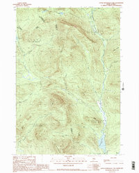
 1990 Twin Peaks1990 Print · USGSThe Maine-Quebec borderlands in the early 1990s reveal a landscape of deep timber and remote watersheds within Oxford County. Researchers can trace the rugged drainage of the Magalloway River and locate isolated features like Twin Peaks, Abbie Pond, and scattered Gravel Pits.
 - 1990 Map of Parmachenee Lake
 1990 Parmachenee Lake1990 Print · USGSNear the Canadian border in the 1990s, this Maine backcountry remains a landscape of unorganized townships and high peaks. Genealogists and local historians can trace the drainages of the Magalloway River and locate remote landmarks like Little Boy Falls, Indian Cove, and Cupsuptic Mountain.2 unique versions available
 - 1994 Map of Rumford
 1994 Rumford1994 Print · USGSWestern Maine's mountains and glacial lakes are shown here in the mid-1990s, from the peaks of the Mahoosuc Range to the banks of the Androscoggin River. Trace the Maine Central RR through Dixfield or locate lakeside settlements like Oquossoc.
 - 1994 Map of Flagstaff Lake
 1994 Flagstaff Lake1994 Print · USGSThe Maine wilderness and the Quebec border come alive in this mid-nineties survey of the Dead River country. Researchers can trace the Appalachian Trail over Bigelow Mountain and locate remote sites like Kennebago Settlement.
 - 1995 Map of Mechanic Falls, 1999 Print
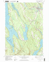 1995 Mechanic Falls1999 Print · USGSSouthern Maine in the mid-nineties shows a landscape of river-driven industry and growing lakefront communities at the meeting of three counties. Researchers can locate family sites near West Poland, trace the Grand Trunk RR, or find Highland Cem and Elm Street Sch.
 - 1995 Map of Umbagog Lake South, 1999 Print
 1995 Umbagog Lake South1999 Print · USGSThe rugged New Hampshire-Maine borderlands are captured here in the mid-1990s as a haven for forestry and conservation. You can trace the wilderness roads through Upton and locate remote landmarks like Metallak Island or the Cem near the Maine state line.
 - 1995 Map of Speckled Mountain, 2000 Print
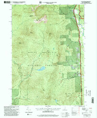
 1995 Speckled Mountain2000 Print · USGSOxford County, Maine, is shown in the mid-1990s as a landscape of protected wilderness and mountain trails within the White Mountain National Forest. Researchers can trace the settlement at Hastings, locate a local Cemetery, and follow the Highwater Trail past Kees Falls.
 - 1995 Map of North Conway East, 2000 Print
 1995 North Conway East2000 Print · USGSThe eastern White Mountains meet the Maine border in the 1990s, centering on the outdoor-recreation hub of North Conway. Local historians can trace the Conway Scenic Railway, explore the footpaths of the Weeks Brook Trail, or locate landmarks like Redstone Ledge and Mineral Spring.
 - 1995 Map of Center Lovell, 2000 Print
 1995 Center Lovell2000 Print · USGSThe Kezar Lake region of Oxford County appears in detail during the mid-nineties, showing the balance between the White Mountain wilderness and lakeside village life. Researchers can locate family landmarks like Smith Cem, Lord Cem, and the old Bemis Cem - Bradley Church.
 - 1995 Map of Wild River, 2000 Print
 1995 Wild River2000 Print · USGSThe White Mountains come alive in the 1990s as this map traces the intricate trail networks and wilderness reaches across the New Hampshire and Maine state line. Researchers can locate remote landmarks like the Brickett Place or trace the Appalachian Trail as it passes Middle Moriah Mountain.
 - 1995 Map of Umbagog Lake North, 2000 Print
 1995 Umbagog Lake North2000 Print · USGSThe northern reaches of the New Hampshire and Maine border are preserved here in the mid-nineties, showing a landscape defined by timber grants and vast water networks. Researchers can trace the early footprints of Wentworth Location and Errol or locate family-named features like Sturtevant Mountain and Mt Dustan.
 - 1995 Map of Gilead, 2000 Print
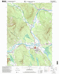
 1995 Gilead2000 Print · USGSOxford County in the mid-nineties shows the town of Gilead nestled along the Androscoggin River as it winds through mountain gaps. Genealogists and hikers can trace family names at Chapman Cemetery, locate the old Gaging Station, and scout the steep slopes of Tumbledown Dick Mountain.
 - 1995 Map of Bethel, 2000 Print
 1995 Bethel2000 Print · USGSThe Oxford Hills come into focus in the mid-nineties as the Androscoggin River valley balances its agricultural roots with a growing recreation economy. Genealogists and local historians can trace family sites at Sunday River Cemetery or locate landmarks like Gould Academy and the historic Covered Bridge.
 - 1995 Map of North Waterford, 2000 Print
 1995 North Waterford2000 Print · USGSOxford County in the late twentieth century remains a landscape of high ridges and glacial ponds, where timber and local industry shaped the rural layout. Genealogists can locate several family burial sites like Webber Cemetery and Haskell Cemetery or trace the early paths through Slab City and Lynchville.
 - 1995 Map of East Stoneham, 2000 Print
 1995 East Stoneham2000 Print · USGSThe foothills of the Oxford County mountains come alive in the mid-nineties, showing a landscape defined by timber, tourism, and deep-rooted settlements. Trace the local geography from East Stoneham north through White Mountain National Forest to find Flat Cemetery, Songo Pond, and Town House.
 - 1995 Map of Chatham, 2000 Print
 1995 Chatham2000 Print · USGSChatham and the White Mountain high country are captured here in the mid-1990s as a haven for hikers and remote settlers. Researchers can trace the trails and summits of Sable Mountain or locate the Cold River AMC Camp and local cemeteries.
 - 1995 Map of Shelburne, 2001 Print
 1995 Shelburne2001 Print · USGSThe northern New Hampshire border and the Wild River territory come alive in the mid-1990s as the Androscoggin River valley meets the high peaks. Hikers and historians can trace the Appalachian Scenic Trail past Gentian Pond and locate the historic Hazelton Cem near Shelburne.
 - 1997 Map of Richardson Pond, 1999 Print
 1997 Richardson Pond1999 Print · USGSOxford County's wilderness is captured here in the late nineties as a landscape of vast lakes and timber plantations. Researchers can trace the shoreline of Aziscohos Lake, find the Aziscohos Dam, and locate remote islands like Big Beaver Island.
 - 1997 Map of Oquossoc, 1999 Print
 1997 Oquossoc1999 Print · USGSThe Rangeley Lakes region is captured here in the late twentieth century, showing the intricate shorelines and sporting camps of the Maine woods. Trace the historic Rangeley Grade or locate remote waterfront sites like Pleasant Island, Upper Dam, and the Oquossoc Angling Assn.
 - 1997 Map of Houghton, 1999 Print
 1997 Houghton1999 Print · USGSThe Maine backcountry near Byron and Rangeley Plantation is captured here in the late twentieth century, showing a landscape shaped by water and timber. Researchers can trace the Old Railroad Grade past Angel Falls or follow the Appalachian National Scenic Trail over Bemis Mtn.
 - 1997 Map of Middle Dam, 1999 Print
 1997 Middle Dam1999 Print · USGSThe North Woods of Oxford County in the late nineties remain a landscape of vast water and mountain ridges. Trace the shoreline of Lower Richardson Lake and find remote landmarks like Middle Dam, Hardscrabble Island, and the Rapid River.
Showing maps 1-25 of 27
Top cities of Oxford County
- Paris historical maps
- Norway historical maps
- Rumford historical maps
- Oxford historical maps
- Fryeburg historical maps
- Mexico historical maps
See more
Frequently asked questions
- What are the different types of historical maps available for Oxford County?
- What is the oldest map of Oxford County?
- Where can I purchase historical maps of Oxford County for my home or office?
- Where can I download high-res historical maps of Oxford County?
- Are there historical topographic maps available for Oxford County?
- Is there historical aerial imagery available for Oxford County?
- Where are historical maps of Oxford County sourced from?