1930s Maps of Oxford County, Maine
Explore 16 historic maps of Oxford County from the 1930s. These maps offer a rare glimpse into what life looked like during the 1930s — showing old roads, neighborhoods, homes, and landmarks that have changed or disappeared over time.
Whether you're researching your family's past, planning a metal detecting trip, or studying how Oxford County's landscape evolved across the 1930s, these high-resolution maps are a powerful tool for exploring the history of this region.
- Focus on a specific era: All maps on this page are from the 1930s, giving you a focused view of this time period.
- See what’s changed: Compare century-old streets, trails, and buildings to today's modern landscape using overlays and satellite layers.
- Research with precision: Use these maps for genealogy, historical research, land use analysis, or educational projects.
- View, download, or print: Maps are fully viewable online in high resolution, and can be downloaded or printed for your own records.
Start exploring Oxford County's history through authentic maps from the 1930s. This is your window into the past.
Oxford County, ME maps
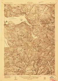
(16)- 1930 Map of Rumford
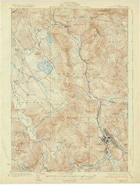 1930 Rumford1930 Print · USGSRumford and the Androscoggin River valley are shown here just before the Great Depression, highlighting a bustling landscape of rail and industry. Genealogists and historians can trace local families through many district schools like Woodrow Sch and landmarks like Stockbridge Cem or Rumford Falls.5 unique versions available
 - 1930 Map of Milan, 1952 Print
 1930 Milan1952 Print · USGSThe upper Androscoggin River valley is captured here in the early thirties, showing a rugged landscape of timber ridges and river-fed settlements. Genealogists can locate several local schools such as Jewett Sch and the rail-side village of Milan.3 unique versions available
 - 1930 Map of Errol, 1955 Print
 1930 Errol1955 Print · USGSThe timberlands along the New Hampshire and Maine border come alive in the 1930s, centered on the river networks that fueled the region. Genealogists and historians can trace remote outposts like Wilsons Mills, the Magalloway Sch, and industrial markers like Errol Dam.5 unique versions available
 - 1931 Map of Cupsuptic
 1931 Cupsuptic1931 Print · USGSOxford County's rugged northern interior comes to life in this early 1930s survey of the Maine woods. Trace the network of remote outposts and waterways that defined the region, from the Parmachenee Club and Riverside Camp to the waters of Cupsuptic Lake.5 unique versions available
 - 1931 Map of Moose Bog
 1931 Moose Bog1931 Print · USGSThe Maine and New Hampshire borderlands are captured here in the early thirties, showing a remote wilderness of high peaks and river headwaters. Genealogists and historians can trace family-named landmarks like Bowman Farm, Bowman Hill, and the secluded waters of Moose Bog.5 unique versions available
 - 1932 Map of Second Lake
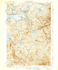
 1932 Second Lake1932 Print · USGSThe northern New Hampshire wilderness and Maine borderlands are captured here in the early 1930s, showing a landscape of logging camps and high peaks. Genealogists and historians can trace old sites like Idlewild, the Deer Mtn Fire Tower, and remote outposts such as Camp No 36.4 unique versions available
 - 1932 Map of Arnold Pond
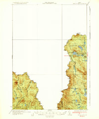
 1932 Arnold Pond1932 Print · USGSThe Maine-Quebec borderlands come into focus in the early 1930s, showing a remote landscape of mountain ponds and international crossings. Trace the old route of State Highway No 143 past the U S Customs station near Arnold Pond and Crosby Pond.3 unique versions available
 - 1933 Map of Rangeley
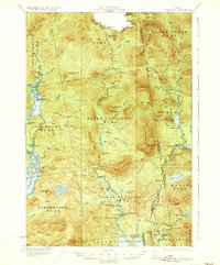
 1933 Rangeley1933 Print · USGSThe Rangeley Lakes region is shown here in the early 1930s, capturing a landscape of timber townships and mountain peaks. Genealogists and historians can locate rural schoolhouses like the Lakeside School, the Dallas station railroad stop, and the abandoned Flagg Dam.2 unique versions available
 - 1933 Map of Milan, 1940 Print
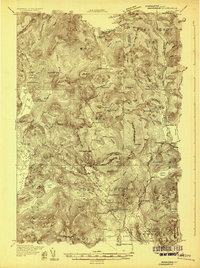
 1933 Milan1940 Print · USGSCoos County at the start of the 1930s shows a landscape of timbered peaks and river-valley settlements connected by the Grand Trunk. Genealogists can locate several rural schools like Jewett Sch and Milan Hill Sch alongside the Berlin Landing Field.
 - 1934 Map of Cupsuptic
 1934 Cupsuptic1934 Print · USGSThe Maine wilderness at the edge of the Canadian border was a landscape of remote camps and river systems in the early thirties. Trace the locations of early outposts like Cupsuptic Sporting Camp, the Game Wardens Camp, and the high-elevation Fire Tower on West Kennebago Mtn.
 - 1934 Map of Errol
 1934 Errol1934 Print · USGSThe Maine-New Hampshire borderlands in the 1930s reveal a landscape of vast timber grants and river-driven settlements. Genealogists and historians can trace the remote Wentworths Location and find landmarks like the Magalloway Sch and College Farm.5 unique versions available
 - 1934 Map of Milan
 1934 Milan1934 Print · USGSThe northern New Hampshire timberlands near Milan and the Maine border are seen here in the mid-1930s. Genealogists and hikers can trace the original Mahoosuc Trail or locate vanished rural schoolhouses like Hamlin Sch and Pontook Sch.2 unique versions available
 - 1935 Map of Cupsuptic
 1935 Cupsuptic1935 Print · USGSNorthwestern Maine's remote forests are documented in the 1930s, showing a landscape defined by hunting camps and logging rivers. Researchers can locate vanished outposts like Moochers Home, Parmachenee Club, and Cupsuptic Sporting Camp along the river networks.3 unique versions available
 - 1935 Map of Arnold Pond
 1935 Arnold Pond1935 Print · USGSThe international border between Maine and Quebec is captured here in the mid-1930s, showing the remote township lines and high mountain peaks. You can trace the path of Route 4 past U.S. Customs and explore the alpine waters of Arnold Pond and Big Island Pond.3 unique versions available
 - 1937 Map of Gorham
 1937 Gorham1937 Print · USGSNew Hampshire's high peaks and river valleys are shown in detail during the late 1930s as the regional economy balanced rail industry with forest conservation. Genealogists and hikers can trace the Appalachian Trail, locate Civilian Conservation Corps sites like CCC Camp Gorham, and study the industrial corridors of the Grand Trunk Railway.6 unique versions available
 - 1939 Map of Rangeley
 1939 Rangeley1939 Print · USGSRangeley and the surrounding Maine high country are shown here in the years before the Second World War. Researchers can trace the original path of the Appalachian Trail past Saddleback Mtn and locate old rural landmarks like Lakeside Sch.5 unique versions available
End of results
Showing maps 1-16 of 16
Top cities of Oxford County
- Paris historical maps
- Norway historical maps
- Rumford historical maps
- Oxford historical maps
- Fryeburg historical maps
- Mexico historical maps
See more
Frequently asked questions
- What are the different types of historical maps available for Oxford County?
- What is the oldest map of Oxford County?
- Where can I purchase historical maps of Oxford County for my home or office?
- Where can I download high-res historical maps of Oxford County?
- Are there historical topographic maps available for Oxford County?
- Is there historical aerial imagery available for Oxford County?
- Where are historical maps of Oxford County sourced from?