1950s Maps of Oxford County, Maine
Explore 9 historic maps of Oxford County from the 1950s. These maps offer a rare glimpse into what life looked like during the 1950s — showing old roads, neighborhoods, homes, and landmarks that have changed or disappeared over time.
Whether you're researching your family's past, planning a metal detecting trip, or studying how Oxford County's landscape evolved across the 1950s, these high-resolution maps are a powerful tool for exploring the history of this region.
- Focus on a specific era: All maps on this page are from the 1950s, giving you a focused view of this time period.
- See what’s changed: Compare century-old streets, trails, and buildings to today's modern landscape using overlays and satellite layers.
- Research with precision: Use these maps for genealogy, historical research, land use analysis, or educational projects.
- View, download, or print: Maps are fully viewable online in high resolution, and can be downloaded or printed for your own records.
Start exploring Oxford County's history through authentic maps from the 1950s. This is your window into the past.
Oxford County, ME maps
(9)- 1950 Map of Cupsuptic
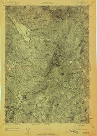
 1950 Cupsuptic1950 Print · USGSThe northern Maine woods come alive in this mid-century survey of the remote townships near the Canadian border. Researchers can trace the heritage of historic logging and sporting sites like the Parmachenee Club, Moochers Home, and Riverside Camp.
 - 1950 Map of Lewiston
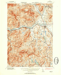
 1950 Lewiston1950 Print · USGSThe Maine and New Hampshire borderlands come alive in this post-war survey of the White Mountains and Androscoggin valley. Genealogists and historians can trace rail lines like the Maine Central Railroad and find high-altitude landmarks from Mount Washington to Bretton Woods.2 unique versions available
 - 1953 Map of Bethel
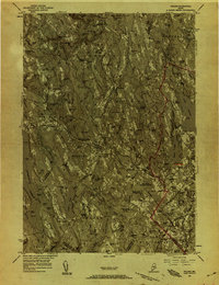
 1953 Bethel1953 Print · USGSThe Androscoggin River valley is captured here in the early 1950s, showing the agricultural and mountain landscape of Oxford County. Local historians can trace old community hubs like Bethel, Gilead, and Hanover, along with numerous rural schoolhouses such as Chapman Sch and Peabody Sch.2 unique versions available
 - 1956 Map of Dixfield, 1958 Print
 1956 Dixfield1958 Print · USGSIn the mid-1950s, the western Maine landscape centered on the bustling river town of Dixfield and the expanses of Mt Blue State Park. Genealogists and historians can trace family cemeteries like Birchland Cem and old industrial sites like Hildreths Mill.5 unique versions available
 - 1956 Map of Poland, 1958 Print
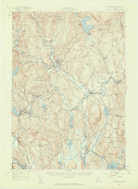
 1956 Poland1958 Print · USGSMid-Maine's river valleys and hillsides are documented here during the mid-fifties, featuring a landscape of paper mills, sanatoriums, and rural hamlets. Researchers can trace the busy rail junctions at Danville Jct or locate the historic resort grounds at Poland Spring.4 unique versions available
 - 1956 Map of Farmington, 1959 Print
 1956 Farmington1959 Print · USGSMid-century Franklin County, Maine, reveals a landscape of river-driven industry and upland farming. Researchers can trace the rail connections through Wilton Station or locate family roots near Knowltons Corner, Intervale School, and Savage Cemetery.3 unique versions available
 - 1956 Map of Portland, 1963 Print
 1956 Portland1963 Print · USGSSouthern Maine and eastern New Hampshire are captured here in the mid-fifties, during a time of major highway expansion and military growth. You can trace the path of the Maine Turnpike and locate landmarks like the Portsmouth Naval Shipyard and Sebago Lake.4 unique versions available
 - 1956 Map of Lewiston, 1975 Print
 1956 Lewiston1975 Print · USGSThe Northern New England interior is documented here in the mid-fifties, from the industrial Androscoggin River to the high peaks of the White Mountains. Trace the Grand Trunk Railway through mountain passes or locate family landmarks near Sabbathday Lake and Bretton Woods.
 - 1959 Map of Portland
 1959 Portland1959 Print · USGSThe Maine and New Hampshire coastlines meet in this mid-century portrait of maritime commerce and inland rail networks. Researchers can trace the legacy of coastal defense at Fort Williams and follow the historic path of the Maine Central RR through the White Mountain National Forest.2 unique versions available
End of results
Showing maps 1-9 of 9
Top cities of Oxford County
- Paris historical maps
- Norway historical maps
- Rumford historical maps
- Oxford historical maps
- Fryeburg historical maps
- Mexico historical maps
See more
Frequently asked questions
- What are the different types of historical maps available for Oxford County?
- What is the oldest map of Oxford County?
- Where can I purchase historical maps of Oxford County for my home or office?
- Where can I download high-res historical maps of Oxford County?
- Are there historical topographic maps available for Oxford County?
- Is there historical aerial imagery available for Oxford County?
- Where are historical maps of Oxford County sourced from?