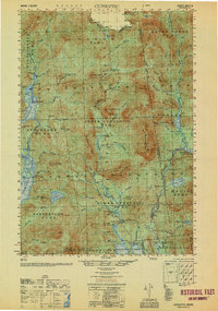
1950 Map of Cupsuptic
USGS Topo · Published 1950About this map
Kennebago Lake and the surrounding wilderness of northern Maine define this 1950 edition, which documents a landscape shaped by the logging industry and sporting traditions. The map reveals a network of remote outposts and seasonal habitations, such as the Parmachenee Club on the shores of Aziscohos Lake and the Cupsuptic Sporting Camp near the Kennebago River. These locations, along with humorously named spots like Moochers Home, highlight the area's history as a destination for outdoor recreation and timber management. The terrain is divided into numbered townships like Upper Cupsuptic, where the absence of major towns is compensated by numerous work camps, including Snow Mountain No 4 Camp and Moose Brook Camp. Large water bodies like Little Kennebago Lake and the winding Cupsuptic River provide the primary geographic framework for this isolated territory.
Find a feature on this map
112 named features on this map. Tap any name to fly to it.
Don’t see what you’re looking for? This feature index may not catch every label — zoom into the map to look around manually.
Map Details
Editions of this 1950 Cupsuptic Map
This is the sole edition of this map. No revisions or reprints were ever made.
Other maps of this area

1927 · Moose Bog
USGS Topo · 1:48,000

1927 · Second Lake
USGS Topo · 1:62,500

1928 · Chain Lakes
USGS Topo · 1:48,000

1930 · Errol
USGS Topo · 1:62,500

1931 · Cupsuptic
USGS Topo · 1:48,000

1931 · Moose Bog
USGS Topo · 1:62,500

1932 · Kennebago Lake
USGS Topo · 1:48,000

1932 · Second Lake
USGS Topo · 1:62,500

1932 · Arnold Pond
USGS Topo · 1:48,000

1932 · Chain Lakes
USGS Topo · 1:62,500