
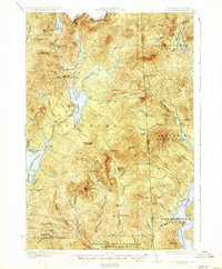
1932 Map of Second Lake
USGS Topo · Published 1932About this map
Second Lake and the upper reaches of the Connecticut Lake system anchor this 1927 survey of the northernmost New Hampshire wilderness. The landscape is defined by its industrial timber heritage, evidenced by a network of numbered logging camps such as Camp No 34 and Camp No 8, alongside landmarks like Schoppe Dam on Third Lake. This era shows a primitive infrastructure where the River Road and a few scattered settlements like Idlewild and Camp Otter provided the only human outposts amidst the peaks of Salmon Mtn and Magalloway Mtn. The map documents the intricate drainage basins of the Dead Diamond River and Little Magalloway River along the Maine-New Hampshire and Canada-United States borders, capturing a moment when the high country was primarily the domain of loggers and early sporting camps.
Find a feature on this map
81 named features on this map. Tap any name to fly to it.
Don’t see what you’re looking for? This feature index may not catch every label — zoom into the map to look around manually.
Map Details
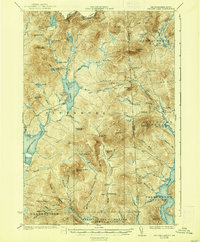
Editions of this 1932 Second Lake Map
4 editions found
Historical Maps of Pittsburg Through Time
260 maps found

1893 Gorham
Coos County, NH

1893 Mt. Washington
Coos County, NH

1896 Gorham
Coos County, NH

1896 Mt. Washington
Coos County, NH

1900 Whitefield
Coos County, NH

1925 Indian Stream
Coos County, NH

1926 Indian Stream
Coos County, NH

1927 Indian Stream
Coos County, NH

1927 Second Connecticut Lake
Coos County, NH

1930 Dixville
Coos County, NH

1930 Milan
Coos County, NH

1930 Percy
Coos County, NH

1932 Second Lake
Coos County, NH

1933 Dixville
Coos County, NH

1933 Milan
Coos County, NH

1934 Dixville
Coos County, NH

1934 Errol
Coos County, NH

1934 Milan
Coos County, NH

1934 Percy
Coos County, NH

1935 Mt. Washington
Coos County, NH

1935 Whitefield
Coos County, NH

1937 Gorham
Coos County, NH

1938 Mt. Washington
Coos County, NH

1938 Whitefield
Coos County, NH

1942 Gorham
Coos County, NH

1970 Carter Dome
Coos County, NH

1970 Shelburne
Coos County, NH

1970 Wild River
Coos County, NH

1976 Success Pond
Coos County, NH

1976 Umbagog Lake North
Coos County, NH

1976 Umbagog Lake South
Coos County, NH

1982 Bethlehem
Coos County, NH

1982 Lancaster
Coos County, NH

1982 Mt. Washington
Coos County, NH

1982 Pliny Range
Coos County, NH

1986 Sherbrooke
Coos County, NH

1987 Stairs Mountain
Coos County, NH

1988 Blue Mountain
Coos County, NH

1988 Dixville Notch
Coos County, NH

1988 Dummer Ponds
Coos County, NH

1988 Errol
Coos County, NH

1988 Milan
Coos County, NH

1988 Percy Peaks
Coos County, NH

1988 Stark
Coos County, NH

1988 Stratford
Coos County, NH

1988 Success Pond
Coos County, NH

1988 Teakettle Ridge
Coos County, NH

1988 Tinkerville
Coos County, NH

1988 Umbagog Lake North
Coos County, NH

1988 Umbagog Lake South
Coos County, NH

1988 West Milan
Coos County, NH

1989 Cowen Hill
Coos County, NH

1989 Diamond Pond
Coos County, NH

1989 Greeley Brook
Coos County, NH

1989 Lake Francis
Coos County, NH

1989 Lovering Mountain
Coos County, NH

1989 Magalloway Mtn
Coos County, NH

1989 Metallak Mountain
Coos County, NH

1989 Mount Pisgah
Coos County, NH

1989 Pittsburg
Coos County, NH

1989 Prospect Hill
Coos County, NH

1989 Second Connecticut Lake
Coos County, NH

1995 Carter Dome
Coos County, NH

1995 Errol
Coos County, NH

1995 Jefferson
Coos County, NH

1995 Mount Crescent
Coos County, NH

1995 Mount Dartmouth
Coos County, NH

1995 Mount Washington
Coos County, NH

1995 Shelburne
Coos County, NH

1995 Stairs Mountain
Coos County, NH

1995 Stark
Coos County, NH

1995 Twin Mountain
Coos County, NH

1995 Umbagog Lake North
Coos County, NH

1995 Umbagog Lake South
Coos County, NH

1995 West Milan
Coos County, NH

1995 Wild River
Coos County, NH

1996 Blue Mountain
Coos County, NH

1996 Diamond Pond
Coos County, NH

1996 Dixville Notch
Coos County, NH

1996 Dummer Ponds
Coos County, NH

1996 Lovering Mountain
Coos County, NH

1996 Percy Peaks
Coos County, NH

1997 Magalloway Mtn
Coos County, NH

1997 Second Connecticut Lake
Coos County, NH

2000 Teakettle Ridge
Coos County, NH

2012 Bunnell Mountain
Coos County, NH

2012 Carter Dome
Coos County, NH

2012 Cowen Hill
Coos County, NH

2012 Diamond Pond
Coos County, NH

2012 Dixville Notch
Coos County, NH

2012 Dummer Ponds
Coos County, NH

2012 Errol
Coos County, NH

2012 Greeley Brook
Coos County, NH

2012 Jefferson
Coos County, NH

2012 Lake Francis
Coos County, NH

2012 Lancaster
Coos County, NH

2012 Lovering Mountain
Coos County, NH

2012 Magalloway Mountain
Coos County, NH

2012 Metallak Mountain
Coos County, NH

2012 Milan
Coos County, NH

2012 Mount Crescent
Coos County, NH

2012 Mount Dartmouth
Coos County, NH

2012 Mount Pisgah
Coos County, NH

2012 Mount Washington
Coos County, NH

2012 Percy Peaks
Coos County, NH

2012 Pittsburg
Coos County, NH

2012 Prospect Hill
Coos County, NH

2012 Second Connecticut Lake
Coos County, NH

2012 Shelburne
Coos County, NH

2012 Stairs Mountain
Coos County, NH

2012 Stark
Coos County, NH

2012 Stratford
Coos County, NH

2012 Success Pond
Coos County, NH

2012 Teakettle Ridge
Coos County, NH

2012 Tinkerville
Coos County, NH

2012 Twin Mountain
Coos County, NH

2012 Umbagog Lake North
Coos County, NH

2012 Umbagog Lake South
Coos County, NH

2012 West Milan
Coos County, NH

2012 Wild River
Coos County, NH

2015 Bunnell Mountain
Coos County, NH

2015 Carter Dome
Coos County, NH

2015 Cowen Hill
Coos County, NH

2015 Diamond Pond
Coos County, NH

2015 Dixville Notch
Coos County, NH

2015 Dummer Ponds
Coos County, NH

2015 Errol
Coos County, NH

2015 Greeley Brook
Coos County, NH

2015 Jefferson
Coos County, NH

2015 Lake Francis
Coos County, NH

2015 Lancaster
Coos County, NH

2015 Lovering Mountain
Coos County, NH

2015 Magalloway Mountain
Coos County, NH

2015 Metallak Mountain
Coos County, NH

2015 Milan
Coos County, NH

2015 Mount Crescent
Coos County, NH

2015 Mount Dartmouth
Coos County, NH

2015 Mount Pisgah
Coos County, NH

2015 Mount Washington
Coos County, NH

2015 Percy Peaks
Coos County, NH

2015 Pittsburg
Coos County, NH

2015 Prospect Hill
Coos County, NH

2015 Second Connecticut Lake
Coos County, NH

2015 Shelburne
Coos County, NH

2015 Stairs Mountain
Coos County, NH

2015 Stark
Coos County, NH

2015 Stratford
Coos County, NH

2015 Success Pond
Coos County, NH

2015 Teakettle Ridge
Coos County, NH

2015 Tinkerville
Coos County, NH

2015 Twin Mountain
Coos County, NH

2015 Umbagog Lake North
Coos County, NH

2015 Umbagog Lake South
Coos County, NH

2015 West Milan
Coos County, NH

2015 Wild River
Coos County, NH

2018 Bunnell Mountain
Coos County, NH

2018 Carter Dome
Coos County, NH

2018 Cowen Hill
Coos County, NH

2018 Diamond Pond
Coos County, NH

2018 Dixville Notch
Coos County, NH

2018 Dummer Ponds
Coos County, NH

2018 Errol
Coos County, NH

2018 Greeley Brook
Coos County, NH

2018 Jefferson
Coos County, NH

2018 Lake Francis
Coos County, NH

2018 Lancaster
Coos County, NH

2018 Lovering Mountain
Coos County, NH

2018 Magalloway Mountain
Coos County, NH

2018 Metallak Mountain
Coos County, NH

2018 Milan
Coos County, NH

2018 Mount Crescent
Coos County, NH

2018 Mount Dartmouth
Coos County, NH

2018 Mount Pisgah
Coos County, NH

2018 Mount Washington
Coos County, NH

2018 Percy Peaks
Coos County, NH

2018 Pittsburg
Coos County, NH

2018 Prospect Hill
Coos County, NH

2018 Second Connecticut Lake
Coos County, NH

2018 Shelburne
Coos County, NH

2018 Stairs Mountain
Coos County, NH

2018 Stark
Coos County, NH

2018 Stratford
Coos County, NH

2018 Success Pond
Coos County, NH

2018 Teakettle Ridge
Coos County, NH

2018 Tinkerville
Coos County, NH

2018 Twin Mountain
Coos County, NH

2018 Umbagog Lake North
Coos County, NH

2018 Umbagog Lake South
Coos County, NH

2018 West Milan
Coos County, NH

2018 Wild River
Coos County, NH

2021 Bunnell Mountain
Coos County, NH

2021 Carter Dome
Coos County, NH

2021 Cowen Hill
Coos County, NH

2021 Diamond Pond
Coos County, NH

2021 Dixville Notch
Coos County, NH

2021 Dummer Ponds
Coos County, NH

2021 Errol
Coos County, NH

2021 Greeley Brook
Coos County, NH

2021 Jefferson
Coos County, NH

2021 Lake Francis
Coos County, NH

2021 Lancaster
Coos County, NH

2021 Lovering Mountain
Coos County, NH

2021 Magalloway Mountain
Coos County, NH

2021 Metallak Mountain
Coos County, NH

2021 Milan
Coos County, NH

2021 Mount Crescent
Coos County, NH

2021 Mount Dartmouth
Coos County, NH

2021 Mount Pisgah
Coos County, NH

2021 Mount Washington
Coos County, NH

2021 Percy Peaks
Coos County, NH

2021 Pittsburg
Coos County, NH

2021 Prospect Hill
Coos County, NH

2021 Second Connecticut Lake
Coos County, NH

2021 Shelburne
Coos County, NH

2021 Stairs Mountain
Coos County, NH

2021 Stark
Coos County, NH

2021 Stratford
Coos County, NH

2021 Success Pond
Coos County, NH

2021 Teakettle Ridge
Coos County, NH

2021 Tinkerville
Coos County, NH

2021 Twin Mountain
Coos County, NH

2021 Umbagog Lake North
Coos County, NH

2021 Umbagog Lake South
Coos County, NH

2021 West Milan
Coos County, NH

2021 Wild River
Coos County, NH

2024 Bunnell Mountain
Coos County, NH

2024 Carter Dome
Coos County, NH

2024 Cowen Hill
Coos County, NH

2024 Diamond Pond
Coos County, NH

2024 Dixville Notch
Coos County, NH

2024 Dummer Ponds
Coos County, NH

2024 Errol
Coos County, NH

2024 Greeley Brook
Coos County, NH

2024 Jefferson
Coos County, NH

2024 Lake Francis
Coos County, NH

2024 Lancaster
Coos County, NH

2024 Lovering Mountain
Coos County, NH

2024 Magalloway Mountain
Coos County, NH

2024 Metallak Mountain
Coos County, NH

2024 Milan
Coos County, NH

2024 Mount Crescent
Coos County, NH

2024 Mount Dartmouth
Coos County, NH

2024 Mount Pisgah
Coos County, NH

2024 Mount Washington
Coos County, NH

2024 Percy Peaks
Coos County, NH

2024 Pittsburg
Coos County, NH

2024 Prospect Hill
Coos County, NH

2024 Second Connecticut Lake
Coos County, NH

2024 Shelburne
Coos County, NH

2024 Stairs Mountain
Coos County, NH

2024 Stark
Coos County, NH

2024 Stratford
Coos County, NH

2024 Success Pond
Coos County, NH

2024 Teakettle Ridge
Coos County, NH

2024 Tinkerville
Coos County, NH

2024 Twin Mountain
Coos County, NH

2024 Umbagog Lake North
Coos County, NH

2024 Umbagog Lake South
Coos County, NH

2024 West Milan
Coos County, NH

2024 Wild River
Coos County, NH
Featured Locations
- Pittsburg, NH
- Atkinson and Gilmanton Academy Grant, NH
- Clarksville, NH
- Parmachenee Township, ME
- Lynchtown Township, ME