1940s Maps of C Surplus, Maine
Explore 4 historic maps of C Surplus from the 1940s. These maps offer a rare glimpse into what life looked like during the 1940s — showing old roads, neighborhoods, homes, and landmarks that have changed or disappeared over time.
Whether you're researching your family's past, planning a metal detecting trip, or studying how C Surplus's landscape evolved across the 1940s, these high-resolution maps are a powerful tool for exploring the history of this region.
- Focus on a specific era: All maps on this page are from the 1940s, giving you a focused view of this time period.
- See what’s changed: Compare century-old streets, trails, and buildings to today's modern landscape using overlays and satellite layers.
- Research with precision: Use these maps for genealogy, historical research, land use analysis, or educational projects.
- View, download, or print: Maps are fully viewable online in high resolution, and can be downloaded or printed for your own records.
Start exploring C Surplus's history through authentic maps from the 1940s. This is your window into the past.
C Surplus, ME maps
(4)- 1940 Map of Oquossoc, 1955 Print
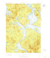 1940 Oquossoc1955 Print · USGSOxford County at the dawn of the 1940s remained a landscape of timber and water, centered on the historic settlements of the Rangeley Lakes. Genealogists and researchers can trace early lakefront communities and the vital water-control sites at Upper Dam, Aziscohos Dam, and Oquossoc.4 unique versions available
 - 1942 Map of Oquossoc
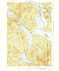 1942 Oquossoc1942 Print · USGSMaine's western lakes and timberlands are captured here in the early 1940s, showing a landscape defined by water and woods. You can trace the Appalachian Trail through the high country or locate remote sporting sites like the Oquossoc Angling Assn and Middle Dam.3 unique versions available
 - 1943 Map of Old Speck Mtn, 1959 Print
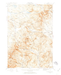 1943 Old Speck Mtn1959 Print · USGSOxford County was a high-elevation wilderness in the 1940s, defined by the Mahoosuc peaks and the early path of the Appalachian Trail. Trace remote outposts like Ketchum and North Newry PO or landmarks like the Old Speck Mtn Fire Tower.4 unique versions available
 - 1945 Map of Old Speck Mtn
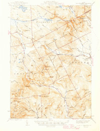 1945 Old Speck Mtn1945 Print · USGSThe Oxford County backcountry in the mid-1940s shows a landscape of timber surpluses and mountain trails. You can trace the Appalachian Trail across Old Speck Mtn or find local heritage sites like the Powers Cem and Ketchum.4 unique versions available
End of results
Showing maps 1-4 of 4
Top cities near C Surplus
- Rumford historical maps
- Bethel historical maps
- Milan historical maps
- Rangeley historical maps
- Andover historical maps
- Newry historical maps
See more
Frequently asked questions
- What are the different types of historical maps available for C Surplus?
- What is the oldest map of C Surplus?
- Where can I purchase historical maps of C Surplus for my home or office?
- Where can I download high-res historical maps of C Surplus?
- Are there historical topographic maps available for C Surplus?
- Is there historical aerial imagery available for C Surplus?
- Where are historical maps of C Surplus sourced from?