Old Maps of Brickett Place, Stow for Genealogy
Trace your family roots with 14 historic maps of Brickett Place. These high-res maps reveal old neighborhoods, homesites, landmarks, and streets — helping you uncover where your ancestors lived and how the area evolved over time.
- Explore historic neighborhoods: Identify where your relatives may have lived in the 1800s or 1900s.
- Compare maps over time: Trace the changes in streets, buildings, and landmarks for multi-generational research.
- Perfect for genealogy & ancestry research: Used by family historians and researchers to map out lineage and migration.
These maps are an incredible resource for exploring your personal connection to Brickett Place's past.
Brickett Place, Stow maps
(14)- 1893 Map of Gorham
 1893 Gorham1893 Print · USGSCovers Brickett Place, including Berlin, Gorham, and other nearby areas8 unique versions available
 - 1896 Map of Gorham
 1896 Gorham1896 Print · USGSCovers Brickett Place, including Berlin, Gorham, and other nearby areas
 - 1937 Map of Gorham
 1937 Gorham1937 Print · USGSCovers Brickett Place, including Berlin, Gorham, and other nearby areas6 unique versions available
 - 1942 Map of Gorham
 1942 Gorham1942 Print · USGSCovers Brickett Place, including Berlin, Gorham, and other nearby areas3 unique versions available
 - 1950 Map of Lewiston
 1950 Lewiston1950 Print · USGSCovers Brickett Place, including Lewiston, Auburn, and other nearby areas2 unique versions available
 - 1956 Map of Lewiston, 1975 Print
 1956 Lewiston1975 Print · USGSCovers Brickett Place, including Lewiston, Auburn, and other nearby areas
 - 1961 Map of Lewiston
 1961 Lewiston1961 Print · USGSCovers Brickett Place, including Lewiston, Auburn, and other nearby areas
 - 1962 Map of Lewiston
 1962 Lewiston1962 Print · USGSCovers Brickett Place, including Lewiston, Auburn, and other nearby areas
 - 1969 Map of Lewiston
 1969 Lewiston1969 Print · USGSCovers Brickett Place, including Lewiston, Auburn, and other nearby areas
 - 1970 Map of Wild River, 1972 Print
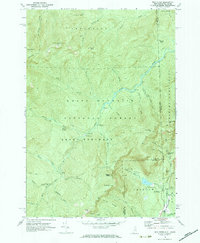 1970 Wild River1972 Print · USGSCovers Brickett Place, including Stow, Shelburne, and other nearby areas3 unique versions available
 - 1986 Map of Mount Washington
 1986 Mount Washington1986 Print · USGSCovers Brickett Place, including Berlin, Saint Johnsbury, and other nearby areas
 - 1988 Map of Mount Washington, 1989 Print
 1988 Mount Washington1989 Print · USGSCovers Brickett Place, including Berlin, Saint Johnsbury, and other nearby areas
 - 1995 Map of Wild River, 2000 Print
 1995 Wild River2000 Print · USGSCovers Brickett Place, including Stow, Shelburne, and other nearby areas
 - 2024 Map of Wild River, 2024 Print
 2024 Wild River2024 Print · USGSCovers Brickett Place, including Stow, Shelburne, and other nearby areas
End of results
Showing maps 1-14 of 14
Frequently asked questions
- What are the different types of historical maps available for Brickett Place?
- What is the oldest map of Brickett Place?
- Where can I purchase historical maps of Brickett Place for my home or office?
- Where can I download high-res historical maps of Brickett Place?
- Are there historical topographic maps available for Brickett Place?
- Is there historical aerial imagery available for Brickett Place?
- Where are historical maps of Brickett Place sourced from?