1930s Maps of East Lowell, Lowell
Explore 2 historic maps of East Lowell from the 1930s. These maps offer a rare glimpse into what life looked like during the 1930s — showing old roads, neighborhoods, homes, and landmarks that have changed or disappeared over time.
Whether you're researching your family's past, planning a metal detecting trip, or studying how East Lowell's landscape evolved across the 1930s, these high-resolution maps are a powerful tool for exploring the history of this region.
- Focus on a specific era: All maps on this page are from the 1930s, giving you a focused view of this time period.
- See what’s changed: Compare century-old streets, trails, and buildings to today's modern landscape using overlays and satellite layers.
- Research with precision: Use these maps for genealogy, historical research, land use analysis, or educational projects.
- View, download, or print: Maps are fully viewable online in high resolution, and can be downloaded or printed for your own records.
Start exploring East Lowell's history through authentic maps from the 1930s. This is your window into the past.
East Lowell, Lowell maps
(2)- 1931 Map of Saponac
 1931 Saponac1931 Print · USGSThe Maine wilderness of the early thirties is captured here before modern development, spanning the border of Penobscot and Hancock counties. Researchers can trace rural life through the locations of the Greenfield Cemetery, the Morrison Mill, and several district schools like School No 1.
 - 1934 Map of Saponac
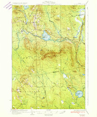 1934 Saponac1934 Print · USGSPenobscot County was a landscape of small mill towns and mountain ridges in the 1930s. Researchers can locate early district schools like Longfellow Sch, industrial sites such as Morrison Mill, and family landmarks including Crocker Turn.3 unique versions available
End of results
Showing maps 1-2 of 2
Frequently asked questions
- What are the different types of historical maps available for East Lowell?
- What is the oldest map of East Lowell?
- Where can I purchase historical maps of East Lowell for my home or office?
- Where can I download high-res historical maps of East Lowell?
- Are there historical topographic maps available for East Lowell?
- Is there historical aerial imagery available for East Lowell?
- Where are historical maps of East Lowell sourced from?