Old Maps of North Newburgh, Newburgh for Academic Research
Study the evolution of North Newburgh with 16 high-resolution historic maps. Whether you're teaching, researching, or modeling changes in land use, these maps provide essential visual documentation of urban, environmental, and geographic change.
- Analyze long-term change: Track patterns in development, transportation, and natural features.
- Ideal for environmental or urban studies: Support academic projects with primary historical map data.
- Use in the classroom or lab: Educators and researchers rely on these maps to bring historical context to life.
These maps are a powerful tool for teaching, research, and visualizing how North Newburgh has changed over the decades.
North Newburgh, Newburgh maps
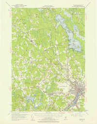
(16)- 1902 Map of Bangor
 1902 Bangor1902 Print · USGSThe Penobscot River valley at the turn of the century shows a bustling hub of rail and river commerce connecting Bangor and Brewer. Genealogists and historians can trace old homesteads and transit routes through Kenduskeag, Leather Corner, and along the Maine Central R. R.6 unique versions available
 - 1942 Map of Bangor
 1942 Bangor1942 Print · USGSThe Penobscot River valley thrives in this early-forties survey of the region's industrial and rural heart. Trace the historic street plans of Bangor and Brewer or locate family homesteads near Leather Corner and Snow Corner.
 - 1946 Map of Bangor
 1946 Bangor1946 Print · USGSBangor and the Penobscot River are captured here in the mid-1940s, showing a critical hub of rail transport and military aviation. Local historians can trace the development of Dow Field, find local schools like Tennyson Sch, or locate family plots in Lakeview Cem.3 unique versions available
 - 1948 Map of Bangor
 1948 Bangor1948 Print · USGSThe Maine coast and its industrial river valleys are captured here shortly after the war, showing the vital shipping and rail hubs of the late 1940s. Genealogists and historians can trace the tracks of the Maine Central RR connecting Bangor, Augusta, and Old Town.
 - 1955 Map of Bangor, 1957 Print
 1955 Bangor1957 Print · USGSBangor and the surrounding Penobscot Valley are captured here in the mid-fifties, showing a landscape defined by riverside industry and lakefront life. Researchers can trace historic rail connections at Northern Maine Junction and locate family landmarks like Lakeside Ldg or Evergreen Cem.3 unique versions available
 - 1956 Map of Bangor, 1966 Print
 1956 Bangor1966 Print · USGSMid-century Maine comes alive in this survey of the rugged coast and river valleys during the 1950s. Genealogists and historians can trace the vital rail corridors of the Maine Central RR connecting timber towns like Old Town to the coast at Bar Harbor.3 unique versions available
 - 1960 Map of Bangor
 1960 Bangor1960 Print · USGSCentral Maine in the sixties reveals a landscape of river-powered industry and sprawling coastal island chains. Researchers can trace the rail corridors of the Maine Central or locate mid-century aviation landmarks like Dow Air Force Base.
 - 1961 Map of Bangor
 1961 Bangor1961 Print · USGSMid-century Maine comes alive through its busy river ports and rocky archipelagoes during a period of steady maritime and rail commerce. Researchers can trace the path of the Maine Central railroad and locate coastal landmarks from Acadia National Park to Vinalhaven Island.
 - 1978 Map of Hermon
 1978 Hermon1978 Print · USGSPenobscot County is captured here in the late seventies, showing a landscape of railroad crossings, small corners, and marshlands. Researchers can trace family history through local burial sites like Lakeview Cem or locate the old Slate Quarry and the Maine Central rail line.
 - 1985 Map of Bangor
 1985 Bangor1985 Print · USGSMid-Maine during the mid-eighties centers on the industrial pulse of the Penobscot River and its critical rail connections. Genealogists and historians can trace the development of river towns from Old Town to Ellsworth and locate regional landmarks like Fort Knox State Park.
 - 1994 Map of Bangor
 1994 Bangor1994 Print · USGSThe Penobscot River valley and the coastal highlands of eastern Maine are captured here in the mid-1990s. Researchers can trace the industrial rail corridors of the Maine Central Railroad or explore the landscape around Old Town, Bucksport, and Graham Lake.
 - 2011 Map of Hermon, 2011 Print
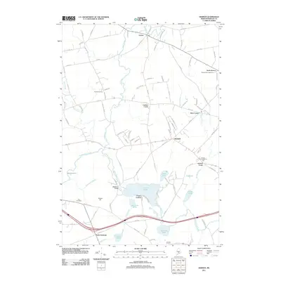 2011 Hermon2011 Print · USGSCovers North Newburgh, including Hampden, Hermon, and other nearby areas
 - 2014 Map of Hermon, 2014 Print
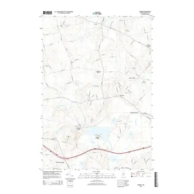 2014 Hermon2014 Print · USGSCovers North Newburgh, including Hampden, Hermon, and other nearby areas
 - 2018 Map of Hermon, 2018 Print
 2018 Hermon2018 Print · USGSCovers North Newburgh, including Hampden, Hermon, and other nearby areas
 - 2021 Map of Hermon, 2021 Print
 2021 Hermon2021 Print · USGSCovers North Newburgh, including Hampden, Hermon, and other nearby areas
 - 2024 Map of Hermon, 2024 Print
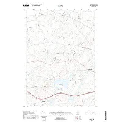
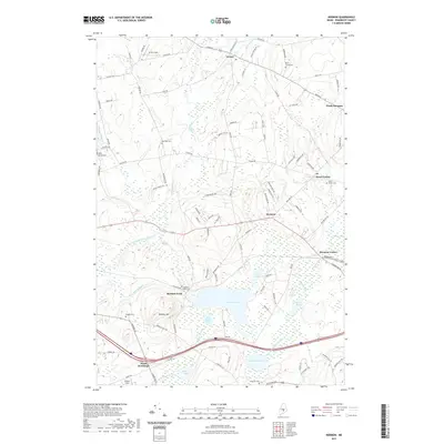
 2024 Hermon2024 Print · USGSPenobscot County in the early twenty-first century maintains a landscape of interconnected hamlets and glacial water bodies. Researchers can locate family roots at Snows Corner Cem or Lakeview Cem and trace the paths of Souadabscook Stream and Patten Stream.
End of results
Showing maps 1-16 of 16
Frequently asked questions
- What are the different types of historical maps available for North Newburgh?
- What is the oldest map of North Newburgh?
- Where can I purchase historical maps of North Newburgh for my home or office?
- Where can I download high-res historical maps of North Newburgh?
- Are there historical topographic maps available for North Newburgh?
- Is there historical aerial imagery available for North Newburgh?
- Where are historical maps of North Newburgh sourced from?