Old Maps of Seboeis Plantation, Maine for Hiking & Exploration
Hike through history with 21 historic maps of Seboeis Plantation. Explore old trails, ghost towns, and forgotten backroads — perfect for outdoor adventurers and local explorers.
- Rediscover forgotten places: Map out old mining camps, roads, and footpaths that no longer exist on modern maps.
- Layer with modern tools: Combine with LiDAR or satellite views to plan hikes through historical terrain.
- Made for exploration: Popular among hikers, overlanders, and local history lovers.
Use these maps to find adventure and explore the hidden past of Seboeis Plantation.
Seboeis Plantation, ME maps
(21)- 1942 Map of Lincoln
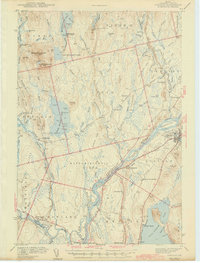 1942 Lincoln1942 Print · USGSPenobscot River life and the timber-driven rail economy are captured here during the early years of the war. Genealogists and historians can locate old landmarks like Merrifield Sch, the Ridge Cem, and the river island communities of the Penobscot Indian Reservation.3 unique versions available
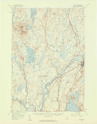
 - 1947 Map of Schoodic, 1956 Print
 1947 Schoodic1956 Print · USGSPiscataquis County in the late 1940s is shown here as a landscape of timber, rail, and isolated lake settlements. Genealogists and historians can trace old homesteads and landmarks like Evergreen Cem, the Maxfield Sch, and the rail stops at Packards or Lake View.3 unique versions available
 - 1949 Map of Schoodic
 1949 Schoodic1949 Print · USGSThe rail-and-river network of central Maine is captured here just after the war, showing the junction of two major rail lines. Genealogists and historians can trace old community sites like Lake View, Knights Landing, and the Maxfield Sch.2 unique versions available
 - 1954 Map of Millinocket, 1968 Print
 1954 Millinocket1968 Print · USGSMaine's North Woods and the Penobscot Valley are captured here during the mid-century era of logging and rail dominance. You can trace the path of the Bangor and Aroostook Railroad through timber towns like Millinocket, Mattawamkeag, and Silver Ridge.3 unique versions available
 - 1957 Map of Lincoln, 1959 Print
 1957 Lincoln1959 Print · USGSPenobscot River towns and the Maine woods are captured here in the late fifties, showing the vital rail-and-river corridor. Genealogists and historians can trace rail lines like the Maine Central, locate the Fairfield Sch, and find the remote Mattamiscontis Club Camp.3 unique versions available
 - 1958 Map of Millinocket
 1958 Millinocket1958 Print · USGSMaine's North Woods and the Penobscot river valley are captured here in the mid-1950s, showing a landscape of timber, rail, and wild waters. Researchers can trace the legacy of the Canadian Pacific railroad and find historic settlements like Millinocket, Sherman Station, and Mattawamkeag.
 - 1960 Map of Millinocket
 1960 Millinocket1960 Print · USGSThe Maine North Woods and Penobscot River valley are captured at mid-century during the height of the paper milling era. Researchers can trace the Appalachian Trail near Mount Katardin or locate family roots in towns like Dover-Foxcroft and Milo.3 unique versions available
 - 1975 Map of Lincoln NW, 1980 Print
 1975 Lincoln NW1980 Print · USGSPenobscot County’s deep woods and glacial lakes are captured in this mid-seventies aerial survey of the Maine wilderness. Researchers can trace the timber-hauling networks around Mattamiscontis Mountain or study the shorelines of Mattamiscontis Lake and South Branch Lake.
 - 1975 Map of Lincoln SW, 1980 Print
 1975 Lincoln SW1980 Print · USGSThe river-driven landscape of central Maine is captured in the mid-seventies, showing the intersection of heavy timberland and critical water routes. Researchers can trace the winding course of the Piscataquis River as it joins the Penobscot River near the edge of Cold Stream Lake.
 - 1978 Map of Endless Lake, 1981 Print
 1978 Endless Lake1981 Print · USGSThe Maine woods and interior waterways are captured in detail during the late seventies, showing the area's undisturbed landscape. Researchers can trace the irregular shorelines of Endless Lake and Seboeis Lake or follow the course of Roaring Brook.
 - 1978 Map of Hardy Pond, 1981 Print
 1978 Hardy Pond1981 Print · USGSMaine's forested interior along the Piscataquis River is captured here in the late seventies. Researchers can trace the layout of Medford and Medford Center or follow the waters of Hardy Pond and Schoodic Stream.
 - 1985 Map of Lincoln, 1994 Print
 1985 Lincoln1994 Print · USGSPenobscot County in the mid-eighties remains a landscape of river-based commerce and sprawling timberlands connected by rail. You can trace the historic paths of the Maine Central RR and Canadian Pacific RR or locate rural sites like Enfield Station and the Winn Cem.
 - 1986 Map of Lincoln
 1986 Lincoln1986 Print · USGSMid-century Maine settlement and industry converge along the Penobscot and Piscataquis rivers during the 1980s. Researchers can trace the rail networks of the Maine Central and Bangor and Aroostook through towns like Howland and Milo.
 - 1988 Map of Mattamiscontis Mtn
 1988 Mattamiscontis Mtn1988 Print · USGSPenobscot County's interior woods and waters are captured here in the late eighties, documenting the wilderness character of the Seboeis Plt region. Trace family-named landmarks like Johnny Ayers Brook or the site of the Mattamiscontis Club Camp.
 - 1988 Map of Endless Lake
 1988 Endless Lake1988 Print · USGSThe Maine backcountry near the Penobscot and Piscataquis county line is captured here in the late eighties, showing a landscape defined by water and timber. Researchers can locate specific landmarks like Dudley Rips, the expanse of One Thousand Acre Bog, and Deadman Cove on the shores of Endless Lake.
 - 1988 Map of Hardy Pond
 1988 Hardy Pond1988 Print · USGSThe Piscataquis River valley in the late 1980s reveals a landscape defined by expansive wetlands and quiet riverfront settlements. Genealogists and local historians can trace the foundations of Medford, Medford Center, and the remote village of Hardy along Hardy Pond.
 - 1988 Map of Seboeis
 1988 Seboeis1988 Print · USGSThe confluence of the Penobscot and Piscataquis rivers serves as the focal point for this late-century survey of central Maine. Researchers can trace the landscape from Howland north through Seboeis Stream and find sites like the Cem and Whitney Ridge.
 - 2024 Map of Hardy Pond, 2024 Print
 2024 Hardy Pond2024 Print · USGSMedford and the Piscataquis River valley are shown here in the 2020s, highlighting a landscape defined by expansive bogs and old transport corridors. Researchers can trace the Abandoned Railroad Grade, locate the Schoodic Cem, and explore the terrain around Hardy Pond.
 - 2024 Map of Endless Lake, 2024 Print
 2024 Endless Lake2024 Print · USGSThe wilderness borderlands of Penobscot and Piscataquis counties are captured here in the early twenty-first century. Outdoorsmen and researchers can trace the shorelines of Endless Lake, navigate the remote reaches of Deadman Cove, or locate the sprawling One Thousand Acre Bog.
 - 2024 Map of Mattamiscontis Mountain, 2024 Print
 2024 Mattamiscontis Mountain2024 Print · USGSPenobscot County in the early 2020s remains a landscape of high ridges and deep woods. You can trace the shorelines of Mattamiscontis Lake and South Branch Lake, locate the remote Seboeis Cem, and follow the timber tracks around Mattamiscontis Mountain.
 - 2024 Map of Seboeis, 2024 Print
 2024 Seboeis2024 Print · USGSPenobscot County is captured in this modern survey where the Piscataquis River meets the Penobscot River at Howland. Researchers can trace old family footprints at Edgcomb Cem or locate seasonal sites around South Branch Lake and Seboeis.
End of results
Showing maps 1-21 of 21
Top cities near Seboeis Plantation
- Lincoln historical maps
- Milo historical maps
- Enfield historical maps
- Medway historical maps
- Brownville historical maps
- Howland historical maps
See more
Frequently asked questions
- What are the different types of historical maps available for Seboeis Plantation?
- What is the oldest map of Seboeis Plantation?
- Where can I purchase historical maps of Seboeis Plantation for my home or office?
- Where can I download high-res historical maps of Seboeis Plantation?
- Are there historical topographic maps available for Seboeis Plantation?
- Is there historical aerial imagery available for Seboeis Plantation?
- Where are historical maps of Seboeis Plantation sourced from?