1950s Maps of T1 R8 WELS, Maine
Explore 5 historic maps of T1 R8 WELS from the 1950s. These maps offer a rare glimpse into what life looked like during the 1950s — showing old roads, neighborhoods, homes, and landmarks that have changed or disappeared over time.
Whether you're researching your family's past, planning a metal detecting trip, or studying how T1 R8 WELS's landscape evolved across the 1950s, these high-resolution maps are a powerful tool for exploring the history of this region.
- Focus on a specific era: All maps on this page are from the 1950s, giving you a focused view of this time period.
- See what’s changed: Compare century-old streets, trails, and buildings to today's modern landscape using overlays and satellite layers.
- Research with precision: Use these maps for genealogy, historical research, land use analysis, or educational projects.
- View, download, or print: Maps are fully viewable online in high resolution, and can be downloaded or printed for your own records.
Start exploring T1 R8 WELS's history through authentic maps from the 1950s. This is your window into the past.
T1 R8 WELS, ME maps
(5)- 1951 Map of Norcross, 1953 Print
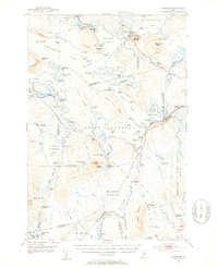 1951 Norcross1953 Print · USGSThe Maine North Woods at mid-century reveal a complex logging and sporting landscape centered on the village of Norcross. Researchers can trace the legacy of the timber trade and wilderness camps at the Boom House, Ambajejus Camps, and Stephensons Landing.5 unique versions available
 - 1951 Map of Millinocket, 1953 Print
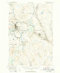 1951 Millinocket1953 Print · USGSThe river-driven industrial landscape of northern Maine comes into focus in the early fifties, where the Penobscot forks meet at Medway. Genealogists and historians can trace the Bangor and Aroostook rail line and locate Bethel Ch or the Lynch Cem.4 unique versions available
 - 1953 Map of Stacyville, 1956 Print
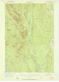 1953 Stacyville1956 Print · USGSThe North Woods of Penobscot County come into focus during the early 1950s, showing a landscape of logging camps and mountain lookouts. Researchers can locate remote sites like Hunt Farm, the Fire Tower on Deasey Mtn, and the old Deasey Dam along the riverbanks.4 unique versions available
 - 1954 Map of Millinocket, 1968 Print
 1954 Millinocket1968 Print · USGSMaine's North Woods and the Penobscot Valley are captured here during the mid-century era of logging and rail dominance. You can trace the path of the Bangor and Aroostook Railroad through timber towns like Millinocket, Mattawamkeag, and Silver Ridge.3 unique versions available
 - 1958 Map of Millinocket
 1958 Millinocket1958 Print · USGSMaine's North Woods and the Penobscot river valley are captured here in the mid-1950s, showing a landscape of timber, rail, and wild waters. Researchers can trace the legacy of the Canadian Pacific railroad and find historic settlements like Millinocket, Sherman Station, and Mattawamkeag.
End of results
Showing maps 1-5 of 5
Top cities near T1 R8 WELS
- Millinocket historical maps
- East Millinocket historical maps
- Medway historical maps
- Patten historical maps
- Stacyville historical maps
Frequently asked questions
- What are the different types of historical maps available for T1 R8 WELS?
- What is the oldest map of T1 R8 WELS?
- Where can I purchase historical maps of T1 R8 WELS for my home or office?
- Where can I download high-res historical maps of T1 R8 WELS?
- Are there historical topographic maps available for T1 R8 WELS?
- Is there historical aerial imagery available for T1 R8 WELS?
- Where are historical maps of T1 R8 WELS sourced from?