1950s Maps of T7 R8 WELS, Maine
Explore 6 historic maps of T7 R8 WELS from the 1950s. These maps offer a rare glimpse into what life looked like during the 1950s — showing old roads, neighborhoods, homes, and landmarks that have changed or disappeared over time.
Whether you're researching your family's past, planning a metal detecting trip, or studying how T7 R8 WELS's landscape evolved across the 1950s, these high-resolution maps are a powerful tool for exploring the history of this region.
- Focus on a specific era: All maps on this page are from the 1950s, giving you a focused view of this time period.
- See what’s changed: Compare century-old streets, trails, and buildings to today's modern landscape using overlays and satellite layers.
- Research with precision: Use these maps for genealogy, historical research, land use analysis, or educational projects.
- View, download, or print: Maps are fully viewable online in high resolution, and can be downloaded or printed for your own records.
Start exploring T7 R8 WELS's history through authentic maps from the 1950s. This is your window into the past.
T7 R8 WELS, ME maps
(6)- 1954 Map of Shin Pond, 1956 Print
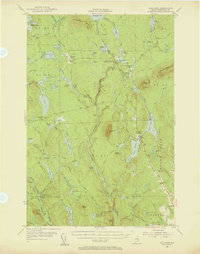 1954 Shin Pond1956 Print · USGSThe Maine North Woods in the 1950s remained a landscape of isolated timber farms and sporting camps. Researchers can trace the early logging infrastructure and river camps at Seboeis Farm, Bowlin Camps, and the settlement at Allsbury.4 unique versions available
 - 1954 Map of Millinocket Lake, 1958 Print
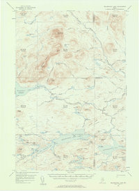 1954 Millinocket Lake1958 Print · USGSThe Maine north woods are documented here during the mid-fifties, showing a landscape of unorganized townships and timberlands. Researchers can trace historic logging routes along the Tote Road and locate remote outposts like Libby Camp and the Forest Service Camp.3 unique versions available
 - 1954 Map of Grand Lake Seboeis, 1958 Print
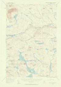 1954 Grand Lake Seboeis1958 Print · USGSThe North Maine Woods in the mid-fifties reveal a rugged landscape of sporting camps and timber townships along the Aroostook River. Genealogists and historians can trace the locations of isolated outposts like Junkins Camp, the Forest Service Camp, and the distant Cunningham Mine.3 unique versions available
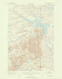
 - 1954 Map of Presque Isle, 1968 Print
 1954 Presque Isle1968 Print · USGSNorth Woods logging and rail history come alive in this mid-century survey of the Maine-Quebec borderlands. Genealogists and historians can trace the Bangor and Aroostook railroad through timber hubs like Ashland, Smyrna Mills, and Presque Isle.2 unique versions available
 - 1955 Map of Traveler Mountain, 1956 Print
 1955 Traveler Mountain1956 Print · USGSNorthern Maine's timberlands and early park boundaries are detailed here in the mid-fifties. Researchers can locate remote logging outposts like Trout Brook Farm, early dams at Norway Dam, and the historic Indian Carry near Grand Pitch.4 unique versions available
 - 1958 Map of Presque Isle
 1958 Presque Isle1958 Print · USGSThe Aroostook timber and potato country is captured here during the late fifties, showing the vital rail-to-river network of Northern Maine. Genealogists and historians can trace the Bangor & Aroostook RR through Mapleton and Ashland, or locate remote sites like Chamberlain Farm and Seven Islands.
End of results
Showing maps 1-6 of 6
Top cities near T7 R8 WELS
Frequently asked questions
- What are the different types of historical maps available for T7 R8 WELS?
- What is the oldest map of T7 R8 WELS?
- Where can I purchase historical maps of T7 R8 WELS for my home or office?
- Where can I download high-res historical maps of T7 R8 WELS?
- Are there historical topographic maps available for T7 R8 WELS?
- Is there historical aerial imagery available for T7 R8 WELS?
- Where are historical maps of T7 R8 WELS sourced from?