Old Maps of Kokadjo, Frenchtown Township for Academic Research
Study the evolution of Kokadjo with 13 high-resolution historic maps. Whether you're teaching, researching, or modeling changes in land use, these maps provide essential visual documentation of urban, environmental, and geographic change.
- Analyze long-term change: Track patterns in development, transportation, and natural features.
- Ideal for environmental or urban studies: Support academic projects with primary historical map data.
- Use in the classroom or lab: Educators and researchers rely on these maps to bring historical context to life.
These maps are a powerful tool for teaching, research, and visualizing how Kokadjo has changed over the decades.
Kokadjo, Frenchtown Township maps
(13)- 1952 Map of First Roach Pond, 1954 Print
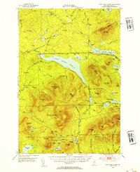 1952 First Roach Pond1954 Print · USGSThe Maine wilderness near Kokadjo is captured here in the early fifties, showing a landscape of timber grants and remote ponds. Researchers can trace the original path of the Appalachian Trail and locate local landmarks like the State Fish Hatchery and VABM Lookout Tower.6 unique versions available
 - 1954 Map of Millinocket, 1968 Print
 1954 Millinocket1968 Print · USGSMaine's North Woods and the Penobscot Valley are captured here during the mid-century era of logging and rail dominance. You can trace the path of the Bangor and Aroostook Railroad through timber towns like Millinocket, Mattawamkeag, and Silver Ridge.3 unique versions available
 - 1958 Map of Millinocket
 1958 Millinocket1958 Print · USGSMaine's North Woods and the Penobscot river valley are captured here in the mid-1950s, showing a landscape of timber, rail, and wild waters. Researchers can trace the legacy of the Canadian Pacific railroad and find historic settlements like Millinocket, Sherman Station, and Mattawamkeag.
 - 1960 Map of Millinocket
 1960 Millinocket1960 Print · USGSThe Maine North Woods and Penobscot River valley are captured at mid-century during the height of the paper milling era. Researchers can trace the Appalachian Trail near Mount Katardin or locate family roots in towns like Dover-Foxcroft and Milo.3 unique versions available
 - 1977 Map of Kokadjo, 1981 Print
 1977 Kokadjo1981 Print · USGSThe Maine North Woods around Kokadjo are shown in clear aerial detail during the late seventies, documenting the timber-and-water landscape. Researchers can trace the network of old woods roads and watercourses like the Roach River and Siras Hill.
 - 1985 Map of Moosehead Lake, 1986 Print
 1985 Moosehead Lake1986 Print · USGSThe Maine North Woods in the 1980s remain a landscape of vast timberlands, railroads, and the sprawling waters of the state's largest lake. Researchers can trace the Canadian Pacific line through Rockwood or locate historical townships from Seboomook to Kokadjo.
 - 1988 Map of Kokadjo
 1988 Kokadjo1988 Print · USGSThe settlement of Kokadjo is captured in the late eighties at its historic position between First Roach Pond and the Roach River. Local historians can trace the Dam and several Sand and Gravel Pits amid the townships of Frenchtown and Spencer Bay.
 - 1994 Map of Moosehead Lake
 1994 Moosehead Lake1994 Print · USGSThe Maine North Woods at the end of the twentieth century remains a landscape of vast timberlands and remote outposts. Researchers can trace the Appalachian National Scenic Trail and locate historic water controls like Chesuncook Dam and Ripogenus Dam.
 - 2011 Map of Kokadjo, 2011 Print
 2011 Kokadjo2011 Print · USGSCovers Kokadjo, including East Middlesex Canal Grant Township, Frenchtown Township, and other nearby areas
 - 2014 Map of Kokadjo, 2014 Print
 2014 Kokadjo2014 Print · USGSCovers Kokadjo, including East Middlesex Canal Grant Township, Frenchtown Township, and other nearby areas
 - 2018 Map of Kokadjo, 2018 Print
 2018 Kokadjo2018 Print · USGSCovers Kokadjo, including East Middlesex Canal Grant Township, Frenchtown Township, and other nearby areas
 - 2021 Map of Kokadjo, 2021 Print
 2021 Kokadjo2021 Print · USGSCovers Kokadjo, including East Middlesex Canal Grant Township, Frenchtown Township, and other nearby areas
 - 2024 Map of Kokadjo, 2024 Print
 2024 Kokadjo2024 Print · USGSThe North Woods settlement of Kokadjo remains a vital gateway for Maine timber and recreation at the edge of the wilderness. Researchers can trace the water systems of First Roach Pond and the Roach River, alongside local landmarks like Sirds Hill.
End of results
Showing maps 1-13 of 13
Top cities near Kokadjo
Frequently asked questions
- What are the different types of historical maps available for Kokadjo?
- What is the oldest map of Kokadjo?
- Where can I purchase historical maps of Kokadjo for my home or office?
- Where can I download high-res historical maps of Kokadjo?
- Are there historical topographic maps available for Kokadjo?
- Is there historical aerial imagery available for Kokadjo?
- Where are historical maps of Kokadjo sourced from?