Old Maps of Nesourdnahunk Township, Maine for Hiking & Exploration
Hike through history with 36 historic maps of Nesourdnahunk Township. Explore old trails, ghost towns, and forgotten backroads — perfect for outdoor adventurers and local explorers.
- Rediscover forgotten places: Map out old mining camps, roads, and footpaths that no longer exist on modern maps.
- Layer with modern tools: Combine with LiDAR or satellite views to plan hikes through historical terrain.
- Made for exploration: Popular among hikers, overlanders, and local history lovers.
Use these maps to find adventure and explore the hidden past of Nesourdnahunk Township.
Nesourdnahunk Township, ME maps
(36)- 1953 Map of Telos Lake, 1955 Print
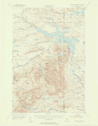
 1953 Telos Lake1955 Print · USGSThe Maine North Woods in the early fifties reveal a remote wilderness of interconnected waterways and logging history. Genealogists and historians can trace the primitive Tote Road and locate early sporting sites like Camp Phoenix or the Telos Dam.
 - 1954 Map of Presque Isle, 1968 Print
 1954 Presque Isle1968 Print · USGSNorth Woods logging and rail history come alive in this mid-century survey of the Maine-Quebec borderlands. Genealogists and historians can trace the Bangor and Aroostook railroad through timber hubs like Ashland, Smyrna Mills, and Presque Isle.2 unique versions available
 - 1955 Map of Traveler Mountain, 1956 Print
 1955 Traveler Mountain1956 Print · USGSNorthern Maine's timberlands and early park boundaries are detailed here in the mid-fifties. Researchers can locate remote logging outposts like Trout Brook Farm, early dams at Norway Dam, and the historic Indian Carry near Grand Pitch.4 unique versions available
 - 1957 Map of Telos Lake, 1960 Print
 1957 Telos Lake1960 Print · USGSPiscataquis County's North Woods are mapped here in the late fifties, showing the logging infrastructure and wilderness boundaries of the era. Trace the path of the Eagle Lake Tote Road or locate remote sites like Camp Phoenix and Telos Dam.4 unique versions available
 - 1958 Map of Presque Isle
 1958 Presque Isle1958 Print · USGSThe Aroostook timber and potato country is captured here during the late fifties, showing the vital rail-to-river network of Northern Maine. Genealogists and historians can trace the Bangor & Aroostook RR through Mapleton and Ashland, or locate remote sites like Chamberlain Farm and Seven Islands.
 - 1960 Map of Presque Isle
 1960 Presque Isle1960 Print · USGSNorthern Maine during the mid-century was a land of timber, rails, and strategic airfields. Genealogists and historians can trace the growth of Presque Isle and Ashland or explore the remote northern reaches of Baxter State Park and Presque Isle AFB.3 unique versions available
 - 1975 Map of Traveler Mountain NW, 1981 Print
 1975 Traveler Mountain NW1981 Print · USGSMaine's northern timberlands are captured in high-detail aerial photography during the mid-seventies. Researchers can trace the wild shoreline of Grand Lake Matagamon and the winding paths of Webster Brook and Trout Brook.
 - 1975 Map of Traveler Mountain SW, 1981 Print
 1975 Traveler Mountain SW1981 Print · USGSThe Maine North Woods are revealed in this mid-seventies aerial survey of the Piscataquis County wilderness. Researchers can study the untouched timberlands and natural drainage surrounding Wassataquoik Lake and North Pogy Mountain.
 - 1985 Map of Oakfield
 1985 Oakfield1985 Print · USGSAroostook County in the 1980s displays a balance between the timber-and-rail industry and the protected wilderness of the North Woods. Genealogists and local historians can trace family-named hubs like Smyrna Mills, Island Falls, and Knowles Corner along the Bangor and Aroostook railroad line.
 - 1986 Map of Chamberlain Lake
 1986 Chamberlain Lake1986 Print · USGSThe Maine North Woods in the mid-eighties appear here as a land of protected wilderness and logging heritage, centered on the Allagash Wilderness Waterway. Researchers can trace the historic Tramway at Chamberlain Lake and locate old outposts like Churchill Depot.
 - 1988 Map of Frost Pond
 1988 Frost Pond1988 Print · USGSBaxter State Park and the northern Maine wilderness are documented here in the late eighties, showing the region's complex lake systems and river portages. Trace the historic Indian Carry along Webster Brook or locate sites like Trout Brook Crossing.
 - 1988 Map of Nesowadnehunk Lake
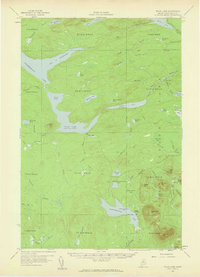
 1988 Nesowadnehunk Lake1988 Print · USGSThe Piscataquis County wilderness is captured in the late eighties as it transitions between managed timberlands and the protected lands of Baxter State Park. Researchers can locate remote backcountry landmarks like Camp Phoenix, Thissell Pond, and the elevations of Strickland Mountain.
 - 1988 Map of Webster Lake
 1988 Webster Lake1988 Print · USGSBaxter State Park and the Maine North Woods are shown here in the late eighties, documenting a landscape of remote township tracts and glacial waters. Researchers can trace historic backcountry sites like Ice Wagon Campsite and the wetlands of Wadleigh Bog or Webster Lake.
 - 1988 Map of Wassataquoik Lake
 1988 Wassataquoik Lake1988 Print · USGSBaxter State Park in the late eighties presents a wilderness of glacial lakes and mountain ridges preserved in its primitive state. Outdoor historians can trace the paths between POGY NOTCH and Six Ponds, or locate landmarks like Black Brook Farm and Inscription Rock.
 - 1994 Map of Chamberlain Lake
 1994 Chamberlain Lake1994 Print · USGSThe North Maine Woods in the early nineties remained a network of logging outposts and protected waterways. You can trace the historic logging infrastructure at Churchill Depot, the portage at Tramway, and remote landings such as Telos Landing.
 - 1994 Map of Oakfield
 1994 Oakfield1994 Print · USGSAroostook County's North Woods and rural settlements are shown here in the mid-1990s, capturing the region's transition from forest to farmland. Trace the path of the Bangor and Aroostook RR through Smyrna Mills or locate landings on Millinocket Lake.
 - 2011 Map of Webster Lake, 2011 Print
 2011 Webster Lake2011 Print · USGSCovers Nesourdnahunk Township, including T5 R11 WELS, T7 R10 WELS, and other nearby areas
 - 2011 Map of Frost Pond, 2011 Print
 2011 Frost Pond2011 Print · USGSCovers Nesourdnahunk Township, including T7 R9 WELS, T5 R9 WELS, and other nearby areas
 - 2011 Map of Wassataquoik Lake, 2011 Print
 2011 Wassataquoik Lake2011 Print · USGSCovers Nesourdnahunk Township, including T4 R9 WELS, T5 R9 WELS, and other nearby areas
 - 2011 Map of Nesowadnehunk Lake, 2011 Print
 2011 Nesowadnehunk Lake2011 Print · USGSCovers Nesourdnahunk Township, including T5 R11 WELS, T4 R11 WELS, and other nearby areas
 - 2014 Map of Webster Lake, 2014 Print
 2014 Webster Lake2014 Print · USGSCovers Nesourdnahunk Township, including T5 R11 WELS, T7 R10 WELS, and other nearby areas
 - 2014 Map of Frost Pond, 2014 Print
 2014 Frost Pond2014 Print · USGSCovers Nesourdnahunk Township, including T7 R9 WELS, T5 R9 WELS, and other nearby areas
 - 2014 Map of Nesowadnehunk Lake, 2014 Print
 2014 Nesowadnehunk Lake2014 Print · USGSCovers Nesourdnahunk Township, including T5 R11 WELS, T4 R11 WELS, and other nearby areas
 - 2014 Map of Wassataquoik Lake, 2014 Print
 2014 Wassataquoik Lake2014 Print · USGSCovers Nesourdnahunk Township, including T4 R9 WELS, T5 R9 WELS, and other nearby areas
 - 2018 Map of Frost Pond, 2018 Print
 2018 Frost Pond2018 Print · USGSCovers Nesourdnahunk Township, including T7 R9 WELS, T5 R9 WELS, and other nearby areas
Showing maps 1-25 of 36
Frequently asked questions
- What are the different types of historical maps available for Nesourdnahunk Township?
- What is the oldest map of Nesourdnahunk Township?
- Where can I purchase historical maps of Nesourdnahunk Township for my home or office?
- Where can I download high-res historical maps of Nesourdnahunk Township?
- Are there historical topographic maps available for Nesourdnahunk Township?
- Is there historical aerial imagery available for Nesourdnahunk Township?
- Where are historical maps of Nesourdnahunk Township sourced from?