1950s Maps of T1 R12 WELS, Maine
Explore 6 historic maps of T1 R12 WELS from the 1950s. These maps offer a rare glimpse into what life looked like during the 1950s — showing old roads, neighborhoods, homes, and landmarks that have changed or disappeared over time.
Whether you're researching your family's past, planning a metal detecting trip, or studying how T1 R12 WELS's landscape evolved across the 1950s, these high-resolution maps are a powerful tool for exploring the history of this region.
- Focus on a specific era: All maps on this page are from the 1950s, giving you a focused view of this time period.
- See what’s changed: Compare century-old streets, trails, and buildings to today's modern landscape using overlays and satellite layers.
- Research with precision: Use these maps for genealogy, historical research, land use analysis, or educational projects.
- View, download, or print: Maps are fully viewable online in high resolution, and can be downloaded or printed for your own records.
Start exploring T1 R12 WELS's history through authentic maps from the 1950s. This is your window into the past.
T1 R12 WELS, ME maps
(6)- 1952 Map of Jo-Mary Mountain, 1953 Print
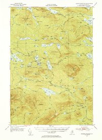 1952 Jo-Mary Mountain1953 Print · USGSCentral Maine's wilderness is captured here in the early fifties, showing the legendary Appalachian Trail as it crosses a landscape of high peaks and isolated ponds. Hikers and researchers can trace the old routes to the Wadleigh Lookout Tower or locate remote camps near Nahamakanta Lake and Jo-Mary Mtn.5 unique versions available
 - 1952 Map of First Roach Pond, 1954 Print
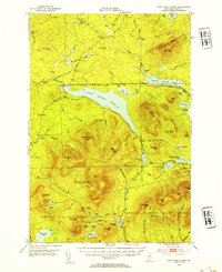 1952 First Roach Pond1954 Print · USGSThe Maine wilderness near Kokadjo is captured here in the early fifties, showing a landscape of timber grants and remote ponds. Researchers can trace the original path of the Appalachian Trail and locate local landmarks like the State Fish Hatchery and VABM Lookout Tower.6 unique versions available
 - 1954 Map of Grant Farm, 1955 Print
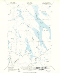 1954 Grant Farm1955 Print · USGSNorthern Maine's timberlands and lake systems are captured here in the mid-1950s before significant modern development. Researchers can trace historic township boundaries and remote outposts like Grant Farm or locate the Lookout Tower on Big Spencer Mtn.6 unique versions available
 - 1954 Map of Harrington Lake, 1956 Print
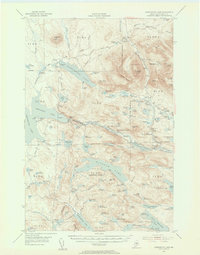 1954 Harrington Lake1956 Print · USGSThe North Woods of the 1950s come alive in this survey of the Penobscot river system and its rugged interior peaks. Trace the early path of the Appalachian Trail past Rainbow Lake or locate the infrastructure at Ripogenus Dam and the Forest Service Camp.5 unique versions available
 - 1954 Map of Millinocket, 1968 Print
 1954 Millinocket1968 Print · USGSMaine's North Woods and the Penobscot Valley are captured here during the mid-century era of logging and rail dominance. You can trace the path of the Bangor and Aroostook Railroad through timber towns like Millinocket, Mattawamkeag, and Silver Ridge.3 unique versions available
 - 1958 Map of Millinocket
 1958 Millinocket1958 Print · USGSMaine's North Woods and the Penobscot river valley are captured here in the mid-1950s, showing a landscape of timber, rail, and wild waters. Researchers can trace the legacy of the Canadian Pacific railroad and find historic settlements like Millinocket, Sherman Station, and Mattawamkeag.
End of results
Showing maps 1-6 of 6
Top cities near T1 R12 WELS
Frequently asked questions
- What are the different types of historical maps available for T1 R12 WELS?
- What is the oldest map of T1 R12 WELS?
- Where can I purchase historical maps of T1 R12 WELS for my home or office?
- Where can I download high-res historical maps of T1 R12 WELS?
- Are there historical topographic maps available for T1 R12 WELS?
- Is there historical aerial imagery available for T1 R12 WELS?
- Where are historical maps of T1 R12 WELS sourced from?