1950s Maps of Perry Cove, West Bath
Explore 6 historic maps of Perry Cove from the 1950s. These maps offer a rare glimpse into what life looked like during the 1950s — showing old roads, neighborhoods, homes, and landmarks that have changed or disappeared over time.
Whether you're researching your family's past, planning a metal detecting trip, or studying how Perry Cove's landscape evolved across the 1950s, these high-resolution maps are a powerful tool for exploring the history of this region.
- Focus on a specific era: All maps on this page are from the 1950s, giving you a focused view of this time period.
- See what’s changed: Compare century-old streets, trails, and buildings to today's modern landscape using overlays and satellite layers.
- Research with precision: Use these maps for genealogy, historical research, land use analysis, or educational projects.
- View, download, or print: Maps are fully viewable online in high resolution, and can be downloaded or printed for your own records.
Start exploring Perry Cove's history through authentic maps from the 1950s. This is your window into the past.
Perry Cove, West Bath maps
(6)- 1950 Map of Phippsburg
 1950 Phippsburg1950 Print · USGSCoastal Sagadahoc County during the mid-twentieth century reveals a landscape of maritime defense and granite-hewn industry. Genealogists and researchers can locate family-named plots like Harris Cem, historic landmarks such as Fort Popham, and industrial sites including the Old Mica Mine.
 - 1956 Map of Bath, 1974 Print
 1956 Bath1974 Print · USGSCoastal Maine in the mid-fifties reveals a landscape of deep-water harbors and island outposts as the region transitioned from industrial roots to a summer destination. Genealogists can trace maritime families in Boothbay Harbor, Tenants Harbor, and on remote Monhegan Island.
 - 1957 Map of Bath
 1957 Bath1957 Print · USGSThe Maine coast in the mid-fifties is captured here, from the shipbuilding hubs of Bath and Brunswick to the granite reaches of Rockland. Researchers can trace the Maine Central RR line and remote island outposts like Monhegan Island and Matinicus Isle.
 - 1957 Map of Phippsburg, 1959 Print
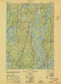
 1957 Phippsburg1959 Print · USGSCoastal Sagadahoc County is shown in detail during the mid-fifties, from the Kennebec mouth to the granite ridges of Phippsburg. Researchers can trace historical defenses at Fort Popham, locate the Old Mica Mine, and find local landmarks like the Sebasco School and West Point Church.2 unique versions available
 - 1957 Map of Bath, 1960 Print
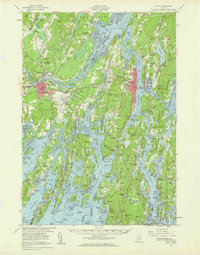 1957 Bath1960 Print · USGSThe mid-coast of Maine is captured here during a period of military and industrial growth along the Kennebec River. Genealogists and historians can trace the foundations of Bath and Brunswick, identifying family plots like Maple Grove Cem and the historic Bowdoin College campus.4 unique versions available
 - 1958 Map of Bath
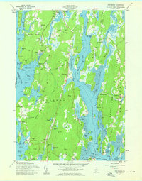
 1958 Bath1958 Print · USGSCoastal Maine in the late fifties reveals a landscape of industrial river towns and remote island outposts. Genealogists and historians can trace the Maine Central RR through Bath, explore the islands of Muscongus Bay, or locate seafaring families at Pemaquid Point.
End of results
Showing maps 1-6 of 6
Frequently asked questions
- What are the different types of historical maps available for Perry Cove?
- What is the oldest map of Perry Cove?
- Where can I purchase historical maps of Perry Cove for my home or office?
- Where can I download high-res historical maps of Perry Cove?
- Are there historical topographic maps available for Perry Cove?
- Is there historical aerial imagery available for Perry Cove?
- Where are historical maps of Perry Cove sourced from?