1950s Maps of Bowtown Township, Maine
Explore 7 historic maps of Bowtown Township from the 1950s. These maps offer a rare glimpse into what life looked like during the 1950s — showing old roads, neighborhoods, homes, and landmarks that have changed or disappeared over time.
Whether you're researching your family's past, planning a metal detecting trip, or studying how Bowtown Township's landscape evolved across the 1950s, these high-resolution maps are a powerful tool for exploring the history of this region.
- Focus on a specific era: All maps on this page are from the 1950s, giving you a focused view of this time period.
- See what’s changed: Compare century-old streets, trails, and buildings to today's modern landscape using overlays and satellite layers.
- Research with precision: Use these maps for genealogy, historical research, land use analysis, or educational projects.
- View, download, or print: Maps are fully viewable online in high resolution, and can be downloaded or printed for your own records.
Start exploring Bowtown Township's history through authentic maps from the 1950s. This is your window into the past.
Bowtown Township, ME maps
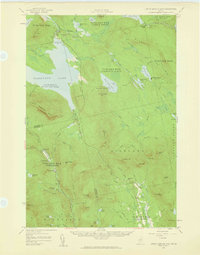
(7)- 1950 Map of Dead River
 1950 Dead River1950 Print · USGSSomerset and Franklin Counties are shown during a time of isolated farms and remote plantations in the mid-twentieth century. Researchers can locate early schoolhouses like Dead River Sch and trace the old postal route at Carry Pond PO.
 - 1954 Map of Millinocket, 1968 Print
 1954 Millinocket1968 Print · USGSMaine's North Woods and the Penobscot Valley are captured here during the mid-century era of logging and rail dominance. You can trace the path of the Bangor and Aroostook Railroad through timber towns like Millinocket, Mattawamkeag, and Silver Ridge.3 unique versions available
 - 1956 Map of Little Bigelow Mtn, 1959 Print
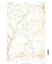
 1956 Little Bigelow Mtn1959 Print · USGSSomerset and Franklin counties are shown here in the mid-fifties, just after the waters of the Dead River were impounded. Researchers can locate remote seasonal outposts like West Carry Camps, the Highland Sch, and the winding path of the Appalachian Trail.4 unique versions available
 - 1956 Map of The Forks, 1961 Print
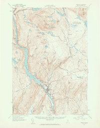
 1956 The Forks1961 Print · USGSSomerset County’s river-driven landscape is captured here in the mid-fifties, centered on the vital junction of the Kennebec River. Genealogists and historians can locate the Franklin Sch, trace the old route of Shirley Road, and find the lakeside settlement of Troutdale.5 unique versions available
 - 1956 Map of Bingham, 1962 Print
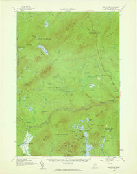
 1956 Bingham1962 Print · USGSThe Kennebec River valley in the mid-1950s shows a landscape of hydropower and high-elevation ponds before significant modern development. Genealogists and historians can trace the footprint of Bingham and Moscow, locate the Longfellow Sch, and follow the Appalachian Trail past Pleasant Ridge.2 unique versions available
 - 1958 Map of Millinocket
 1958 Millinocket1958 Print · USGSMaine's North Woods and the Penobscot river valley are captured here in the mid-1950s, showing a landscape of timber, rail, and wild waters. Researchers can trace the legacy of the Canadian Pacific railroad and find historic settlements like Millinocket, Sherman Station, and Mattawamkeag.
 - 1958 Map of Pierce Pond, 1960 Print
 1958 Pierce Pond1960 Print · USGSSomerset County's remote townships and river corridors are meticulously charted during the mid-century peak of the Maine sporting camp tradition. Researchers can locate established backcountry sites like Grace Pond Camp, the fields of Salmon Stream Farm, and the waters of Enchanted Pond.3 unique versions available
End of results
Showing maps 1-7 of 7
Top cities near Bowtown Township
- Bingham historical maps
- Carrabassett Valley historical maps
- Moscow historical maps
- Pleasant Ridge Plantation historical maps
- Caratunk historical maps
- Highland Plantation historical maps
See more
Frequently asked questions
- What are the different types of historical maps available for Bowtown Township?
- What is the oldest map of Bowtown Township?
- Where can I purchase historical maps of Bowtown Township for my home or office?
- Where can I download high-res historical maps of Bowtown Township?
- Are there historical topographic maps available for Bowtown Township?
- Is there historical aerial imagery available for Bowtown Township?
- Where are historical maps of Bowtown Township sourced from?